
- Where
- Miri Division, Sarawak
northern Borneo, Malaysia - Coordinates
- 4.0400° N
114.8200° E - Biome
- Lowland and montane rainforest,
limestone karst, moss forest - The park
- 52,864 ha; no road access
four show caves open to visitors - Caves
- At least 295 km explored
- Status
- UNESCO World Heritage, 2000
- Best visited
- Year-round; it rains
in every month
Walked a long way on a raised wooden path through dripping forest, hornbills going over like someone beating a carpet, to a hole in a pale cliff so big the forest went in with me. Inside, the dark smelled very strongly of something I will not describe, and the roof was full of small noises. At dusk we sat below it and the mountain began to pour: a black ribbon twisting out of the rock and away over the trees, on and on, longer than I could keep counting.
The short answer
Gunung Mulu National Park lies in the north-east of Sarawak, the Malaysian state on Borneo, close to the border with Brunei. It covers 52,864 hectares of rainforest around three mountains: Gunung Mulu itself, a sandstone peak of about 2,376 metres, and the limestone massifs of Gunung Api and Gunung Benarat. UNESCO calls it the most studied tropical karst area in the world. Beneath it lie at least 295 kilometres of explored cave, among them the Sarawak Chamber, Deer Cave and the Clearwater system. The park was gazetted in 1974, opened to the public in 1985 (1984 in some accounts) and inscribed as a World Heritage Site in 2000. No road has ever been built to it, by policy: visitors arrive by air, or by a long river journey, and around ninety per cent of the park and ninety-five per cent of its caves are closed to visitors except for research.
Why it's worth knowing
Mulu is a place of records, and the records are the least reliable thing about it.
UNESCO’s statement of the park’s value, written for the inscription, says that Deer Cave is the largest cave passage in the world known at the present time. It was, when that was written. In 2009 a British-Vietnamese expedition surveyed Hang Sơn Đoòng in central Vietnam and found a larger one — the library’s own entry on Son Doong covers it.
The same statement gives the Clearwater Cave system 110 kilometres of mapped passage. Expeditions kept connecting it to its neighbours: 102 km by 1991, 129 km by 2005, around 226 km by 2017, and 265.9 km by a count of November 2025, which puts it seventh on published lists of the world’s longest caves. The number in the official record is less than half the cave that is there.
And the Sarawak Chamber, which UNESCO describes at 600 by 415 by 80 metres and 12 million cubic metres, was laser-scanned in 2011 and came out at about 9.6 million cubic metres — while a chamber in China, the Miao Room, has since been reported to be larger by volume. The Sarawak Chamber is still described as the largest known cave chamber by floor area.
None of this makes Mulu less extraordinary. It makes it a place still being measured, by expeditions that have been coming back since 1977, in a park deliberately kept hard to reach. The superlatives are the part that dates. The caves, the forest and the bats at dusk are the part that does not.
The field notes
Deer Cave, and the exodus
Deer Cave — Gua Rusa, named by the Penan and Berawan for the deer that came to lick the salty rock — is reached by a three-kilometre plank walk through the forest from park headquarters. The 1978 Royal Geographical Society expedition measured a section 174 metres wide and 122 metres high. A 2009 survey by the Hoffman Institute at Western Kentucky University extended the known system to 4.1 km and recorded a cross-section of 169 by 125 metres in the southern passage and a ceiling of 148 metres in the northern one. The main entrance is 146 metres high.
At its far end the cave opens into the Garden of Eden, a round valley of rainforest about a kilometre across, walled by limestone cliffs on three sides.
The cave holds at least twelve species of bat, and its population of wrinkle-lipped free-tailed bats is estimated at around three million; other published figures give about two. Almost every evening, weather permitting, they leave the cave in a stream that twists over the forest for many minutes — a ribbon, a coil, a smoke — to feed on insects. A viewing area below the entrance exists for exactly this, and the swiftlets make the opposite journey at the same hour.
The chamber that frightened its discoverers
In January 1981, during the Mulu ’80 expedition, three British cavers — Andy Eavis, Dave Checkley and Tony White — followed a river passage into a cave now called Gua Nasib Bagus, Good Luck Cave, and came out onto a boulder floor in a space their lamps could not reach across. One of them later described the experience as agoraphobia, underground.
Early measurements gave it as 600 metres long, 415 or 435 metres wide and 80 to 115 metres high, depending on the survey. The 2011 laser scan gave 9,579,205 cubic metres and 164,459 square metres of floor. It was estimated at the time as three times the size of the Big Room at Carlsbad Caverns, then thought the largest underground chamber known.
It is not a show cave. Getting there means following an underground river upstream, with swimming and a ledge traverse. The park arranges accompanied visits for experienced and properly equipped people, and they are the most demanding thing Mulu offers.
The Pinnacles
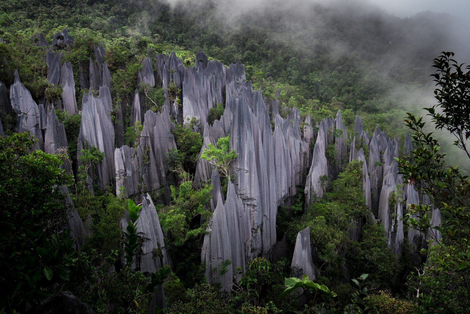
High on the flank of Gunung Api, rain has dissolved the limestone into a forest of grey blades, some of which the park describes as up to fifty metres tall. It is one of the most photographed landscapes in Borneo and it is earned.
The trip is three days. A longboat on the Melinau river, a walk of about nine kilometres to Camp 5, a basic forest shelter with no doors or windows that holds 38 people a night; then, before dawn, a trail the park describes as 2.4 kilometres long and rising 1,200 metres, the last part near vertical on ropes and bolted ladders. The park calls it an extreme climb, not a trek, requires a licensed guide, and does not take anyone sixteen or younger. The descent, it warns, is often harder than the way up.
The road that was never built
When the park was gazetted in 1974, the Sarawak government chose not to build a road to it, and has kept to that. It is the single decision that most shapes the place.
The great 1977–78 Royal Geographical Society expedition — more than a hundred scientists in the field over fifteen months, and the start of the Mulu Caves Project that continues today — worked from a base camp three days upriver from Miri. There was no airport then. There is now, but the forest is still bounded by rivers rather than tarmac, and the old route out on foot, the Headhunters’ Trail, follows a Kayan path to the Limbang side.
The land around the park is lived in and contested. The Penan, once nomadic, are now semi-settled near its south-western edge; the Berawan keep hunting rights in the area. In 2019 Penan and Berawan communities blockaded a logging company working near the park and lodged a complaint with UNESCO. The Sarawak government said the logging would not affect the park. The complaint is on the record either way.
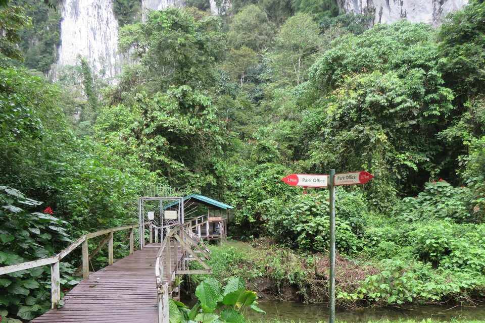
The boardwalk to Deer Cave. There is no road; you walk.
Photograph: Calistemon · CC BY-SA 4.0 · cropped
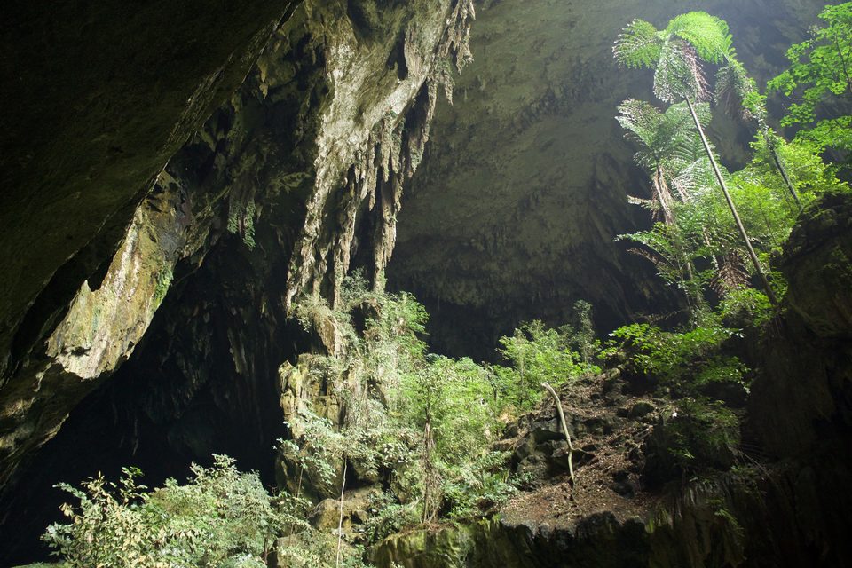
Looking out of Deer Cave towards the forest.
Photograph: John Mason from Edinburgh, UK · Deer Cave (20758751793) · CC BY 2.0 · cropped
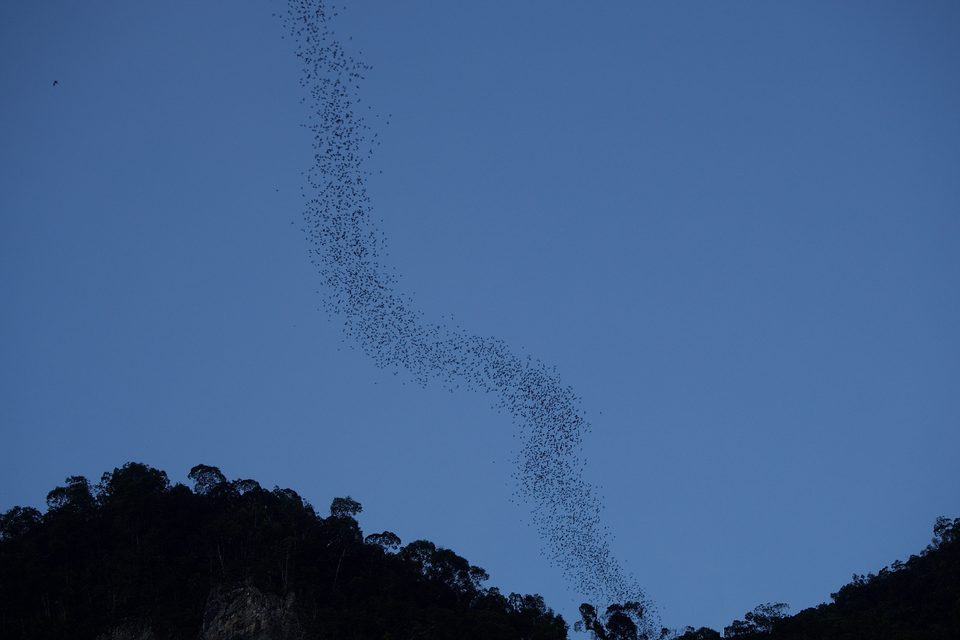
The evening exodus from Deer Cave.
Photograph: John Mason from Edinburgh, UK · Bat exodus (21293935396) · CC BY 2.0 · cropped
- Book the climb to the stone blades before you book the flight. The camp fills.
- Give the bats two evenings. They do not perform on request.
- Walk the boardwalk slowly and look at the small things on it.
- Stand in the cave mouth and let your eyes catch up.
- Try to count the ribbon. Give up. (Item retained.)
A ribbon over the forest. In the late afternoon, below the entrance to Deer Cave, a dark thread appears against the sky, thickens, and begins to twist — millions of wrinkle-lipped bats leaving the mountain to feed, in a stream that coils and loops over the canopy for many minutes. It happens almost every evening, weather permitting, and not on command. Rain can cancel it, which is why a sensible plan allows two evenings.
Tally, in the marginMillions of small animals leaving home at the same hour, in a line, without anyone in charge. I stood there with my mouth open and something flew very close to it.
Getting there
How to get there. Fly. MASwings, part of the Malaysia Airlines group, flies into Mulu’s small airport, most usefully from Miri on the Sarawak coast, about thirty minutes away; other Sarawak and Sabah connections run on some schedules. The alternative is river travel from Marudi up the Baram and Tutoh, which is slow, needs arranging in advance, and has no regular service.
Permits and guides. Every visitor needs a park permit, and the show caves — Deer, Lang’s, Clearwater and Wind — are visited with a park guide in small groups at set times. Adventure caving, the Pinnacles and the Headhunters’ Trail are booked through the park or licensed operators, and Camp 5 has limited beds: book the Pinnacles well ahead.
Timing a visit. Two or three nights is the minimum to see the show caves and the bat exodus without rushing; add three for the Pinnacles. The exodus happens in the late afternoon or early evening and depends on the weather, so plan more than one evening for it.
When to go. Mulu receives four to five metres of rain a year, under the north-east monsoon from about December to March and the south-west from about May to October, and it rains in every month. There is no dry season to wait for; the caves themselves are indifferent to the weather.
Staying. Accommodation is at park headquarters, in homestays in the villages nearby, and at a large resort by the park entrance. Bring a headlamp, insect repellent, clothes that can stay wet, and shoes with grip for the boardwalks.
Mark this place
Common questions
Is Deer Cave the largest cave passage in the world?
Not any longer. Deer Cave in Gunung Mulu National Park was long regarded as the largest cave passage known, and UNESCO’s statement for the park still describes it that way. In 2009 a British-Vietnamese expedition surveyed Hang Sơn Đoòng in Vietnam and found larger passages. Deer Cave’s main entrance is 146 metres high and its passages reach 169 metres wide.
How big is the Sarawak Chamber?
A 2011 laser scan measured the Sarawak Chamber, in Gunung Mulu National Park, at 9,579,205 cubic metres and 164,459 square metres of floor. UNESCO’s statement gives older figures of 600 by 415 by 80 metres and 12 million cubic metres. It is described as the largest known cave chamber by area; the Miao Room in China has been reported as larger by volume.
Who discovered the Sarawak Chamber?
Three British cavers, Andy Eavis, Dave Checkley and Tony White, in January 1981, during the Mulu ’80 expedition. They reached it by following a river passage into Gua Nasib Bagus, Good Luck Cave, in Gunung Mulu National Park, Sarawak. It was estimated at the time as three times the size of the Big Room at Carlsbad Caverns.
How long is the Clearwater Cave system?
The Clearwater Cave system in Gunung Mulu National Park measured 265.9 kilometres in a count of November 2025, placing it seventh on published lists of the world’s longest caves. Its length has grown as expeditions connected it to neighbouring caves: UNESCO’s statement for the park gives 110 km, and published figures pass through 129 km in 2005 and about 226 km in 2017.
How many bats live in Deer Cave?
Deer Cave in Gunung Mulu National Park holds at least twelve bat species, and its wrinkle-lipped free-tailed bat colony is estimated at around three million, with some accounts giving about two million. The bats leave the cave in a long twisting stream almost every evening, weather permitting, and a viewing area below the entrance is provided for watching it.
Can you drive to Mulu National Park?
No. The Sarawak government has kept Gunung Mulu National Park free of road access since it was gazetted in 1974. Visitors fly to Mulu’s airport, most often from Miri, a flight of about thirty minutes, or travel by river from Marudi, which has no regular service and must be arranged in advance.
How hard is the Mulu Pinnacles climb?
The park describes it as an extreme climb rather than a trek. The trip takes three days: a boat ride and a walk of about nine kilometres to Camp 5, then a trail of 2.4 kilometres rising 1,200 metres, the final section on ropes and bolted ladders. A licensed guide is compulsory, the park does not accept anyone aged sixteen or under, and it warns that the descent can take five hours or more.
How much of Mulu National Park can visitors see?
A small fraction by design. About ninety per cent of Gunung Mulu National Park and ninety-five per cent of its caves are closed to visitors except for research. Four show caves — Deer, Lang’s, Clearwater and Wind — are open with park guides, along with a canopy skywalk, forest trails, the Pinnacles climb and a number of adventure caves for equipped groups.