
- Where
- Carmen, Batuan and Sagbayan
central Bohol, Philippines - Coordinates
- 9.9167° N
124.1667° E - How many
- At least 1,260 (Tourism) · 1,268 (Geopark)
about 1,776 (2006 bid) - What they are
- Cone karst
uplifted, weathered marine limestone - Status
- National Geological Monument, 1988
UNESCO Global Geopark, 2023 - Brown season
- Late January to May
per the Department of Tourism - Main viewpoint
- Chocolate Hills Complex, Carmen
over 200 steps
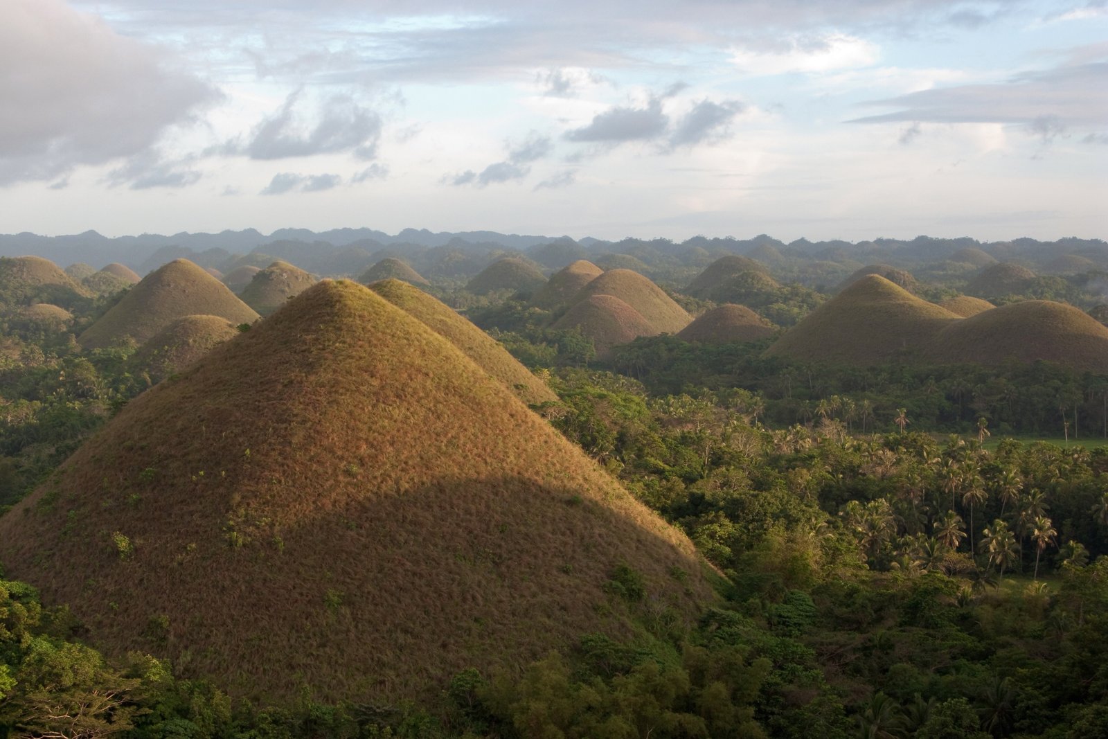
Rode out past the rice fields on the back of a motorbike, and then the land began to bubble: round grassy humps, all about the same size, rising one after another out of the paddies as far as I could see. Climbed a great many steps to look at them properly. They looked like something set out in rows to cool. Nobody could tell me how many there were.
The short answer
The Chocolate Hills are a cone-karst landscape in the interior of Bohol, an island province in the Central Visayas of the Philippines: rounded, near-symmetrical mounds of marine limestone covered in grass, scattered across the municipalities of Carmen, Batuan and Sagbayan and, by Wikipedia’s figure, over more than 50 square kilometres. Rice and other crops are grown on the flat land between them. The grass turns brown in the dry season, which gave them their name. The National Committee on Geological Sciences declared them a National Geological Monument on 18 June 1988; the Philippines submitted them to UNESCO’s World Heritage tentative list on 16 May 2006; and in May 2023 UNESCO designated Bohol Island the country’s first UNESCO Global Geopark, with the hills at its centre.
Why it's worth knowing
For something so famous, the number is strangely loose. The Philippine Department of Tourism describes at least 1,260 hills. The Bohol Island UNESCO Global Geopark, in its UNESCO listing, counts 1,268 conical hills. The Philippines’ own submission to UNESCO’s tentative list in 2006 describes about 1,776 mounds. Wikipedia reconciles them as “a minimum of 1,260 hills, and possibly over 1,776”.
None of these sources explains its method, and the gap is not a scandal so much as a question of definition: where a mound ends and its neighbour begins, how small a rise still counts, and whether two cones joined at the base are one hill or two. A landscape of rounded shapes resists a census.
What is agreed is what they are made of. Wikipedia’s geological account describes Late Pliocene to Early Pleistocene marine limestone, full of the fossils of shallow-water foraminifera, coral, molluscs and algae, lifted above the sea, fractured, and then dissolved by rain and groundwater and cut by streams into cones. The Geopark’s description traces the limestone to coral reefs of the Pliocene, some 2 to 5 million years ago. A bronze plaque at the viewing deck in Carmen, as Wikipedia reports it, says much the same: eroded marine limestone resting on hardened clay. Popular stories of giants, mud fights and a grieving giant’s tears are told on Bohol too, and are told as stories.
The field notes
Protected, and privately owned
The hills are protected several times over: the geological monument of 1988; a presidential proclamation of 1 July 1997, which Wikipedia records as declaring them a natural monument across six municipalities; and the Expanded National Integrated Protected Areas System Act of 2018. But some of the land was titled to private owners before any of that, and Wikipedia records that private ownership is still recognised, with its use restricted and regulated. Wikipedia’s account also describes quarrying as a continuing pressure.
The tension came to a head in March 2024. A video of a resort, Captain’s Peak Garden and Resort, built among the hills in Sagbayan, spread on social media. The Department of Environment and Natural Resources said, as the Philippine News Agency reported, that the resort had never been issued an Environmental Compliance Certificate, yet had obtained building and operating permits from the municipality. The resort stopped operating on 14 March 2024. In May 2024 the Office of the Ombudsman placed the governor of Bohol and 68 other officials on six-month preventive suspension while it investigated; a preventive suspension is not a finding of guilt.
The colour, and the season
The cover is mostly grasses, which Wikipedia names as cogon (Imperata cylindrica) and wild sugarcane (Saccharum spontaneum). In the wet season they are green, and the hills look like a green egg-box; the Department of Tourism puts the brown season at late January to May. Two hills in Carmen were burned in a grass fire on 30 April 2024, in heat Wikipedia gives as a heat index of 41°C.
The earthquake that struck Bohol on the morning of 15 October 2013 was centred near Sagbayan. Part of one hill gave way, and the viewing deck at Carmen was destroyed; it has since been rebuilt.
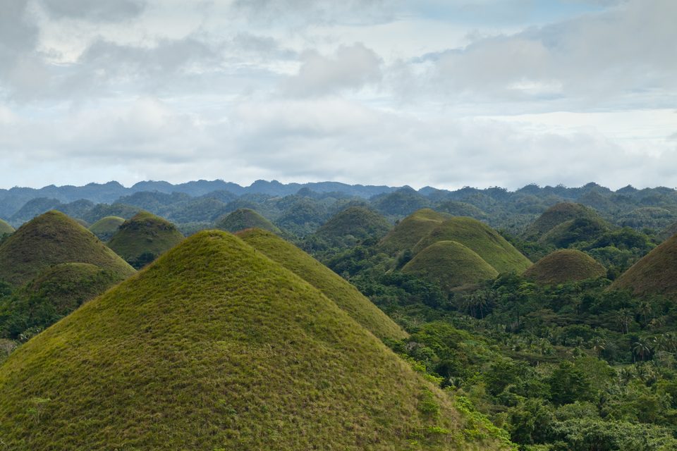
The hills green in early January 2013, before the dry season turns them brown.
Photograph: Sergey Norin · Batuan, Central Visayas (8360778990) · CC BY 2.0
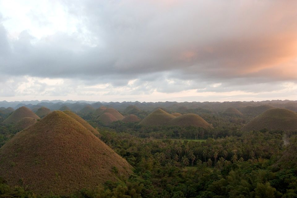
Evening light and cloud over the hills, February 2009.
Photograph: Vyacheslav Argenberg · CC BY 4.0
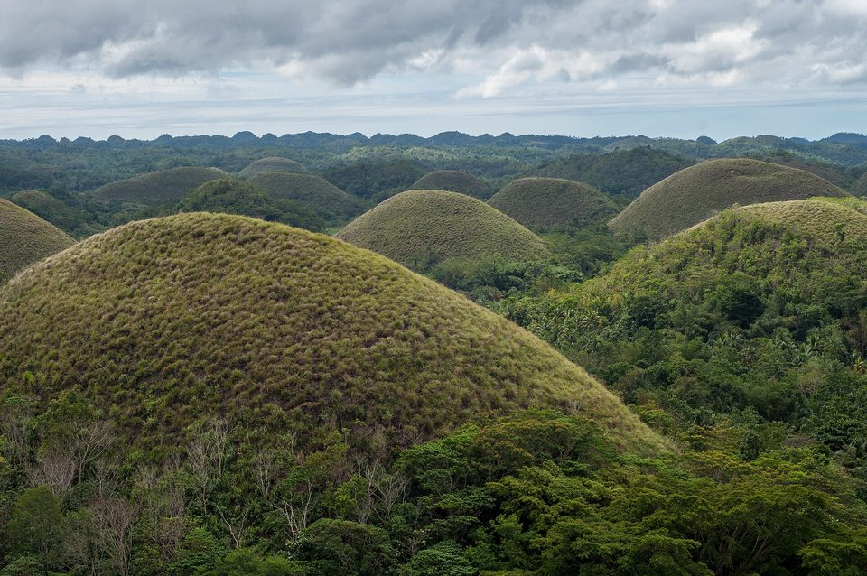
Tufted grass on the flank of one hill, February 2014.
Photograph: Andrewhaimerl · CC BY-SA 4.0
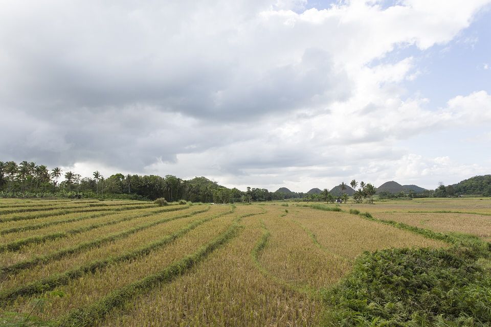
Harvested rice fields with the first hills beyond, April 2019.
Photograph: Leopoldo de Castro · 2019 abr bohol-42 (46800115965) · CC BY 2.0
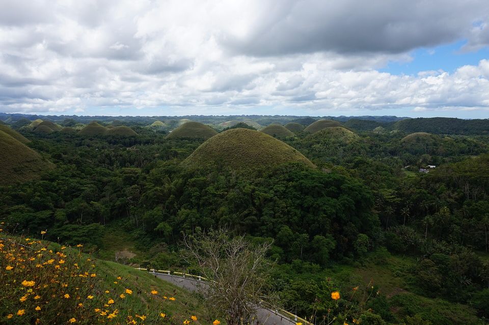
A road winding below a viewpoint among green hills, March 2017.
Photograph: Harry Fozzard · DSC00375 (33614698746) · CC BY 2.0
- Come in the dry months if you want them brown. Come in the wet ones if you want to be told they are usually brown.
- Climb to the viewpoint early, before the heat and the buses.
- Remember that the fields between them are somebody's farm, and keep to the edges and the paths.
- Ride out on the back of a motorbike at least once, and hold on properly.
- Choose a favourite. (Chose one, turned round, and found it had been replaced by dozens exactly like it. Wrote ‘that one’ and drew an arrow.)
A blade of dry-season grass. For part of the year the grass on every mound, mostly cogon and wild sugarcane, dries and turns brown, and the hills become the colour of their name. The brown season runs from late January to May. Outside it the hills are green, which is lovely and is not what anybody came for. You cannot book the colour; you can only choose the month.
Tally, in the marginA blade of grass the colour of the name. Every blade I saw was green, which makes me either a season early or most of one late, and I have decided to come back in the brown and find out which.
Getting there
How to get there. Fly into Bohol–Panglao International Airport on Panglao Island, or take a fast ferry from Cebu to Tagbilaran, the provincial capital; the Department of Tourism gives the ferry as about two hours and advises booking at least a day ahead at weekends and holidays. The two main viewpoints, the government-run Chocolate Hills Complex in Carmen and Sagbayan Peak, are each about an hour by road from Tagbilaran, by the Department’s estimate; buses towards Carmen stop at the junction below the complex.
When to go. Late January to May for the brown, by the Department of Tourism’s reckoning; the rest of the year they are green. The same source suggests avoiding Holy Week and the Christmas and New Year holidays, when the viewing deck becomes crowded.
At the viewpoint. The deck at the Chocolate Hills Complex is reached by over 200 steps, per the Department of Tourism. Stay on the paths and steps. The hills are a protected area, and the fields between them are farms.
What to book ahead. The ferry from Cebu, if you are coming that way, and a driver or a tour if you want to see both viewpoints in a day.
Safety. The United States has the Philippines at Level 2, exercise increased caution, in an advisory reissued on 8 May 2025. It says do not travel to the Sulu Archipelago and Marawi City, and reconsider travel to most of Mindanao; Bohol, in the Visayas, is not named. The nearest land in the Mindanao region, the island of Camiguin, lies roughly 90 km south of the hills across the Bohol Sea, and the Mindanao mainland about 125 km (this entry’s measurements).
Mark this place
Common questions
How many Chocolate Hills are there?
Official counts of the Chocolate Hills in Bohol, Philippines, disagree. The Philippine Department of Tourism describes at least 1,260 hills; the Bohol Island UNESCO Global Geopark counts 1,268; and the Philippines’ 2006 submission to UNESCO’s World Heritage tentative list describes about 1,776 mounds. The differences come down to what counts as a separate hill.
Why are they called the Chocolate Hills?
The Chocolate Hills of Bohol are named for their colour in the dry season, when the grass that covers them, mostly cogon and wild sugarcane, dries out and turns brown. In the wet season they are green. The Philippine Department of Tourism puts the brown season at late January to May.
How were the Chocolate Hills formed?
The Chocolate Hills are cone karst. They are marine limestone of Late Pliocene to Early Pleistocene age, rich in fossils of shallow-water organisms, which was uplifted above the sea, fractured, and then dissolved by rain and groundwater and eroded by streams into rounded cones. The Bohol Island UNESCO Global Geopark traces the limestone to Pliocene coral reefs.
Where are the Chocolate Hills?
The Chocolate Hills are in the interior of Bohol, an island province in the Central Visayas of the Philippines, mainly in the municipalities of Carmen, Batuan and Sagbayan. The main viewpoint, the Chocolate Hills Complex in Carmen, is about an hour by road from Tagbilaran, the provincial capital, according to the Department of Tourism.
Are the Chocolate Hills a UNESCO World Heritage Site?
No. The Philippines submitted the Chocolate Hills to UNESCO’s World Heritage tentative list on 16 May 2006, and they have not been inscribed. They are, however, the centrepiece of the Bohol Island UNESCO Global Geopark, designated by UNESCO in May 2023 as the Philippines’ first global geopark, and a National Geological Monument since 1988.
What was the Chocolate Hills resort controversy?
In March 2024 a video of Captain’s Peak Garden and Resort, built among the Chocolate Hills in Sagbayan, Bohol, spread online. The Department of Environment and Natural Resources said it had never been issued an Environmental Compliance Certificate. It closed on 14 March 2024, and in May 2024 the Ombudsman placed Bohol’s governor and 68 other officials on preventive suspension pending investigation.
Can you climb the Chocolate Hills?
The usual way to see the Chocolate Hills is from a viewpoint. At the Chocolate Hills Complex in Carmen, a viewing deck is reached by over 200 steps, according to the Philippine Department of Tourism; Sagbayan Peak is the other main viewpoint. The hills are a protected natural monument, and some of the land around them is private farmland.
When is the best time to see the Chocolate Hills?
The Philippine Department of Tourism says the Chocolate Hills of Bohol are brown between late January and May, and green for the rest of the year. It suggests avoiding Holy Week and the Christmas and New Year holidays, when the viewing deck at the Chocolate Hills Complex in Carmen is at its most crowded.