
- Where
- North coast of County Antrim,
Northern Ireland, UK - Coordinates
- 55.2408° N
6.5117° W - Rock
- Basalt lava, Paleocene,
about 50–60 million years old - Columns
- About 40,000, mostly six-sided;
the tallest about 12 m - Status
- UNESCO World Heritage, 1986;
National Nature Reserve, 1987 - Access
- The stones are free;
the visitor centre charges - Best visited
- Early morning or evening,
any season
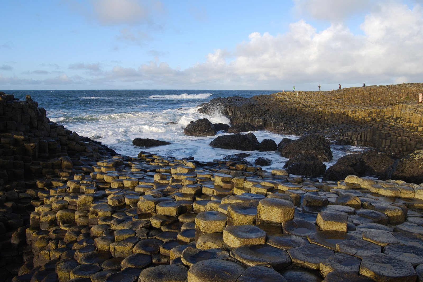
Came down from fields as green as paint, stone walls and sheep to the cliff edge, to a cold grey sea, and found the shore paved. Stepping stones with their corners cut, fitted together like honeycomb and running out under the waves, wet and dark as slate. I went from one to the next looking for a matching pair, and never found one, and did not mind.
The short answer
The Giant’s Causeway is an area of about 40,000 interlocking basalt columns on the north coast of County Antrim, Northern Ireland, about five kilometres north-east of Bushmills. Most of the columns are hexagonal, though some have four, five, seven or eight sides; the tallest stand about twelve metres high, and their tops form a pavement of stepping stones that runs from the foot of the cliffs into the sea. They are the product of a fissure eruption some 50 to 60 million years ago, when this corner of Ireland lay within a great volcanic province. UNESCO inscribed the Giant’s Causeway and Causeway Coast as a World Heritage Site in 1986, and most of it is owned and managed by the National Trust. Walking onto the stones costs nothing; the visitor centre is optional and charges a fee.
Why it's worth knowing
A shore made of regular stone columns asks for an explanation, and it has had three.
The first is the giant. In the best-known telling, the Irish hero Fionn mac Cumhaill built a causeway across the sea to fight the Scottish giant Benandonner, and it was broken up behind a retreating giant. There are matching columns across the water on the Scottish island of Staffa, part of the same ancient lava, and the story may owe something to them.
The second explanation was fought over. From the late eighteenth century, the International Union of Geological Sciences records, the Causeway was at the centre of a fierce dispute about the origin of basalt. The Neptunists, led by Abraham Werner and, locally, by the Reverend William Richardson, held that basalt had precipitated out of seawater. The Vulcanists, among them the Reverend William Hamilton and John Playfair, held that it was volcanic, an idea first proposed by the French geologist Nicolas Desmarest. The Causeway’s columns became evidence for the volcanic side.
Much of that argument was conducted at a distance, through pictures. In 1739 the Dublin artist Susanna Drury painted two views of the Causeway, careful enough to show how the columns were jointed, and by 1745 François Vivares had engraved them in London. Desmarest compared the prismatic basalts of the Auvergne with the Causeway’s columns, and according to Martyn Anglesea and John Preston’s study of Drury, as Wikipedia reports it, an unattributed plate of her East Prospect appeared in a volume of plates for the French Encyclopédie over a caption by Desmarest proposing a volcanic origin. A good deal of the reasoning about this shore was done by people looking at a copy of a picture of it. In 2022 the IUGS listed the Causeway among its first hundred geological heritage sites.
The third explanation fits in a kitchen. As a thick layer of lava cools, it contracts and cracks, and the cracks work downward as a front, organising themselves into a network of roughly equal polygons as they go. A thick layer of cornflour and water does the same thing as it dries. In 2009 Lucas Goehring, L. Mahadevan and Stephen Morris showed in the Proceedings of the National Academy of Sciences that crack spacing from drying-starch experiments and from columnar basalt in the field, including Staffa, collapses onto a single scaling curve. The physics that sets the width of a column in a lava flow sets the width of a column in a baking dish.
The field notes
How lava makes a column
The basalt here arrived as a very fluid lava that broke through the older chalk and built a broad volcanic plateau. As it cooled it shrank, and shrinking rock breaks. The first cracks at the surface meet in the T-junctions of a dried mud puddle; as the cracking front moves down into the flow, the pattern settles into a lower-energy arrangement of roughly equal hexagons.
Horizontal fractures cut the columns into stacked “biscuits”. Many of those joints are curved, one face convex and the one below it concave, which gives the ball-and-socket effect visible where a column has broken. The width of a column is set mainly by how fast the flow cooled: slower cooling, wider columns. Across the wider world, columns of this kind range from a few centimetres to about three metres across.
The painting, the plate and the caption
The Causeway reached the learned world before it reached many learned visitors. William King, Bishop of Derry, went to see it in 1692, and in 1693 Sir Richard Bulkeley, a fellow of Trinity College Dublin, presented a paper on it to the Royal Society in London.
Susanna Drury, of whose life little is known, spent several months in Ulster painting it. In 1740 the Dublin Society awarded her a premium of £25 for the two views, which the Dictionary of Irish Biography records as the first premium for landscape painting in Ireland, and she was the first woman artist in Ireland to receive such recognition. By 1745 François Vivares had engraved them in London, and prints circulated among naturalists.
Wikipedia, citing Anglesea and Preston’s 1980 study in Art History, adds that volume 12 of the Encyclopédie, in 1765, carried an entry on the Causeway that depended on the engravings, and that a later volume of plates reproduced the East Prospect beside two plates of similar basalt in France, over Desmarest’s caption. This entry has not been able to consult the plate or the study directly.
Desmarest had been studying the Auvergne since 1763, and in 1774 he published an essay on its volcanic rocks with a geological map. The originals of Drury’s paintings are in the Ulster Museum in Belfast.
Starch in a dish
The kitchen version of the Causeway was developed as a laboratory tool. Cornflour mixed with water and left to dry in a thick layer forms cracks at the surface that propagate downward as the drying front advances, leaving a block of miniature columns. The PNAS paper describes the connection with a single number, a Péclet number, which ties how fast the cracking front advances to how widely the cracks are spaced. Samples of columns grown in drying starch are held in the University of Toronto’s Scientific Instruments Collection.
What the 2009 paper added was a reason the two patterns look alike: the equations for cracking caused by drying and by cooling have the same form, and one dynamical rule selects the column size in both. That lets measurements of columns from the kitchen and from the field be plotted as one family. The explanation replaces nothing in the legend, which was never about physics, and it replaces nothing in Desmarest; it tells you why his lava and your cornflour agree.
The shapes with names
Millions of years of weathering have made parts of the Causeway resemble things, and the resemblances have names: the Organ, a run of tall columns in the cliff; the Giant’s Boot, a boulder on the shore; the Giant’s Eyes, reddish weathered hollows; the Shepherd’s Steps, the Honeycomb, the Giant’s Harp, the Chimney Stacks, the Giant’s Gate and the Camel’s Hump.
The site became popular with tourists in the nineteenth century, especially after the Giant’s Causeway Tramway opened, and some of the commercial clutter that came with them was removed only after the National Trust took the site into its care in the 1960s. Nearly one million people visited in 2019.
The visitor centre and its exhibits
The present visitor centre opened in 2012, after the site had gone twelve years without one: the 1986 building burned down in 2000. It was funded by the National Trust, the Northern Ireland Tourist Board, the Heritage Lottery Fund and public donations.
It opened with exhibits that mentioned the Young Earth creationist view of the Causeway’s age, and after a campaign and a review the National Trust amended them so that the scientific account, which dates the rock to about 60 million years ago, is the primary explanation; the creationist view is now presented as the belief of some religious communities. The Trust’s own position, as it stated at the time, is that it fully supports the scientific explanation.
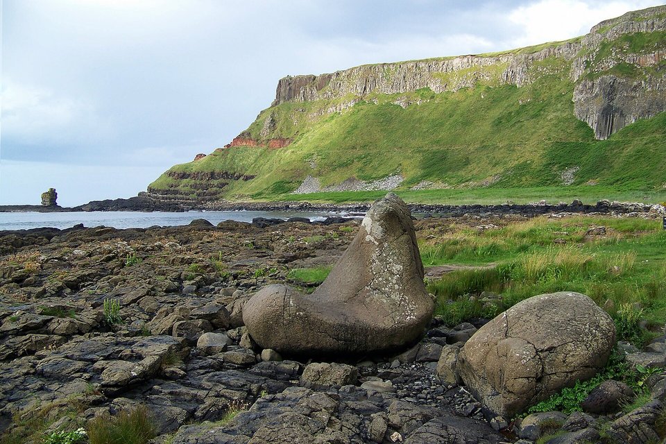
The Giant’s Boot, a boulder on the shore below the cliffs.
Photograph: Einaz80 · CC BY-SA 4.0 · cropped
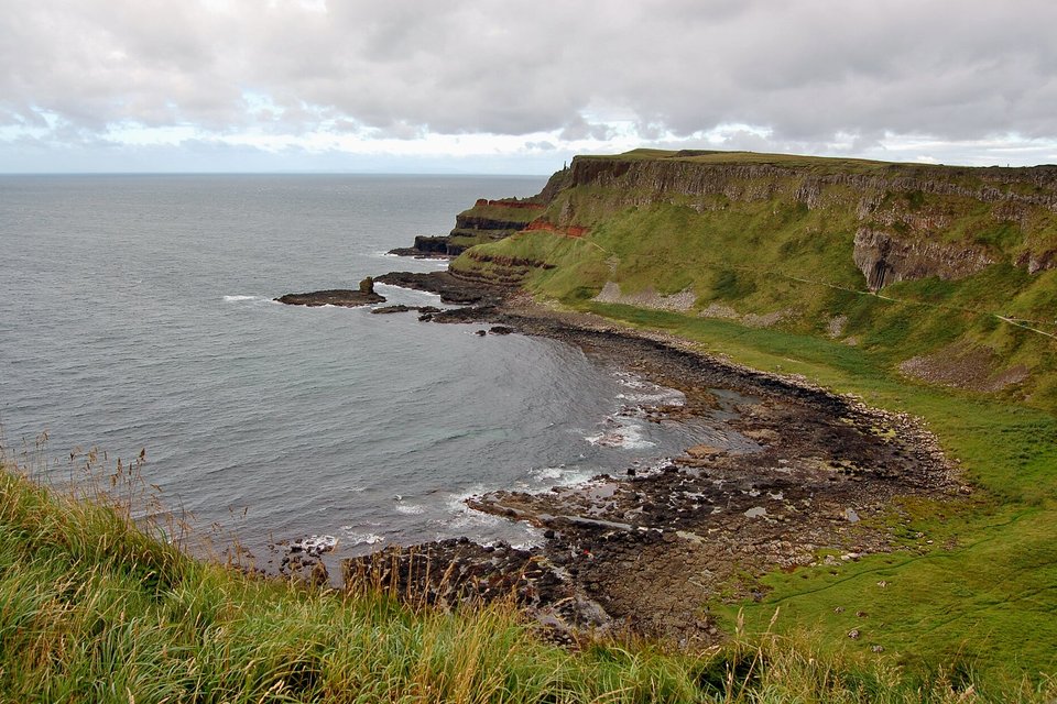
Port Noffer, the bay east of the Causeway, with the Organ Pipes set into the headland at right.
Photograph: Bahnfrend · CC BY-SA 4.0 · cropped
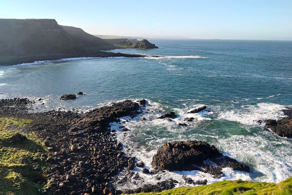
The coast from above the Organ Pipes, surf breaking on the dark rocks below.
Photograph: Barrowbob · CC BY-SA 4.0 · cropped
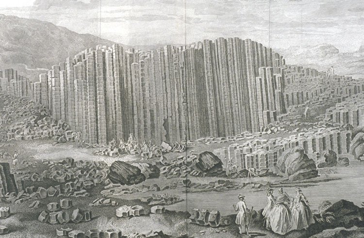
Drury’s “East Prospect” as copied, unattributed, into the Encyclopédie’s plates of 1768 (Linda Hall Library copy).
Engraving: after Susanna Drury, Encyclopédie plates, 1768 · Public domain
- Come early or late, when the stones are nearly empty and the sea is doing the talking.
- Wear shoes that grip. The tops are wet.
- Find the boot, and decide whose it is.
- Let someone from here tell you the giant story, and do not correct them. It is theirs.
- Dry some cornflour in a dish when you get home, and watch what it does. (Added on the way back. The list is longer than when I arrived.)
The Giant’s Boot. Down on the shore below the columns lies a boulder of the same basalt, weathered by millions of years of sea and rain into the shape of an enormous boot. It is one of the named formations of the Causeway, with the Organ and the Chimney Stacks, and the legend supplies an owner: a giant in a hurry. It is easy to walk straight past, which most people do, looking the other way at the columns.
Tally, in the marginA stone boot, lying on the shore as though somebody left in a hurry. I had walked straight past it before it was pointed out, and now I cannot stop wondering where the other one went.
Getting there
How to get there. The Causeway is on the north Antrim coast about five kilometres north-east of Bushmills. Belfast and City of Derry are the nearest airports. By rail, the Belfast–Derry line runs to Coleraine, with a branch to Portrush, and Ulsterbus services connect the stations to the Causeway. On foot, a coastal walk of about eleven kilometres from Portrush passes Dunluce Castle. Many visitors drive.
What costs money and what does not. Access to the stones is free. You do not have to go through the visitor centre, which charges a fee. Check the National Trust’s current prices and opening hours before you go rather than relying on a travel article.
When to go. Any season. The coast is at its emptiest early in the morning and in the evening, which is also when the light is lowest across the columns. Summer brings the most visitors; winter brings the biggest seas.
On the stones. The column tops are uneven and often wet, and the seaward edge takes waves. Wear shoes that grip, keep back from the water in a swell, and follow any closures the National Trust posts. Do not take pieces of rock away.
Nearby. The Causeway Coast runs on either side, with Dunluce Castle to the west and the rope bridge at Carrick-a-Rede to the east.
Mark this place
Common questions
What is the Giant’s Causeway?
The Giant’s Causeway is an area of about 40,000 interlocking basalt columns on the north coast of County Antrim, Northern Ireland, formed when thick lava from a fissure eruption cooled and cracked about 50 to 60 million years ago. Most columns are hexagonal and the tallest are about 12 metres high. UNESCO listed the Giant’s Causeway and Causeway Coast as a World Heritage Site in 1986.
Why are the Giant’s Causeway columns hexagonal?
Because cooling lava shrinks and cracks. At the Giant’s Causeway the cracks began at the surface of thick basalt flows and grew downward as a front, rearranging into a network of roughly equal polygons, most often six-sided, as they went. Some columns have four, five, seven or eight sides. The speed of cooling set the width of the columns.
Can you make a Giant’s Causeway with cornflour?
Yes. A thick layer of cornflour and water cracks into miniature columns as it dries, geometrically like the basalt of the Giant’s Causeway. In 2009 Goehring, Mahadevan and Morris showed in the Proceedings of the National Academy of Sciences that crack spacing from drying starch and from columnar basalt in the field, including Staffa, collapses onto one scaling curve.
What is the legend of the Giant’s Causeway?
In the best-known version, the Irish hero Fionn mac Cumhaill built the Giant’s Causeway across the sea to fight the Scottish giant Benandonner. In one telling Fionn wins; in another his wife Sadhbh disguises him as a baby, Benandonner flees, and the causeway is broken behind him. Matching basalt columns on the Scottish island of Staffa belong to the same ancient lava.
What part did the Giant’s Causeway play in geology?
From the late eighteenth century the Giant’s Causeway was at the centre of the dispute over the origin of basalt, according to the International Union of Geological Sciences. Neptunists such as Abraham Werner held that basalt precipitated from seawater; Vulcanists followed Nicolas Desmarest in holding it volcanic, and the Causeway’s columns became evidence for them. Susanna Drury’s 1739 paintings, engraved by 1745, carried its image to naturalists.
Is the Giant’s Causeway free to visit?
Yes. Access to the stones of the Giant’s Causeway is free, and visitors do not have to go through the National Trust visitor centre, which charges a fee. The Causeway is about five kilometres north-east of Bushmills in County Antrim, and can also be reached on foot along an eleven-kilometre coastal path from Portrush.
How old is the Giant’s Causeway?
The basalt of the Giant’s Causeway formed during the Paleocene, about 50 to 60 million years ago, when intense volcanic activity in County Antrim spread fluid lava over the older chalk. The National Trust, which manages most of the site, supports this scientific dating as the primary explanation in its visitor centre, which opened in 2012.
Who owns the Giant’s Causeway?
Most of the Giant’s Causeway and Causeway Coast World Heritage Site is owned and managed by the National Trust, which took over the Causeway’s care in the 1960s. The rest belongs to the Crown Estate and several private landowners. The Department of the Environment for Northern Ireland declared it a national nature reserve in 1987.