
- Where
- Fatick Region, western Senegal
where the Saloum meets the Atlantic - Coordinates
- 13.8353° N
16.4986° W - Biome
- Mangrove, brackish channels,
mudflat and dry forest - Shell mounds
- 218 recorded, grouped in 96 sites
28 carrying burial tumuli - Oldest dated
- About 400 BC, by radiocarbon
- Status
- UNESCO World Heritage, 2011
- Best visited
- November–May, the dry season
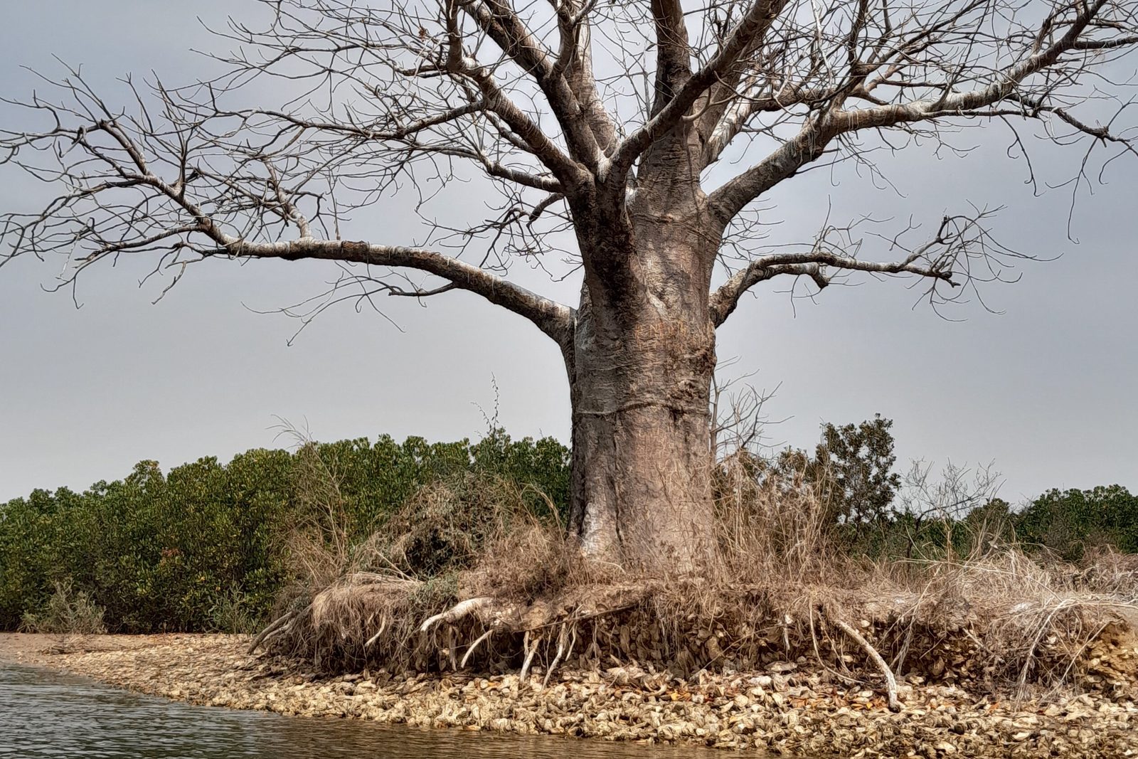
Went out in a long painted boat through flat brown channels between mangroves, birds lifting off ahead of us, and landed on a low island that crunched. The whole ground was broken shell, pale as bone, with one vast bare-limbed tree standing on top as if it had been planted to mark the spot, which in a way it had. Further along, women were bent over the mud with baskets, working, and did not look up.
The short answer
The Saloum Delta is the mangrove delta where the Saloum, Diombos and Bandiala rivers reach the Atlantic in western Senegal, about a hundred kilometres south of Dakar and just north of the Gambian border. Its brackish channels, called bolons, thread between more than two hundred islands and islets. UNESCO inscribed 145,811 hectares of it in 2011 — not for the mangroves, although they are part of it, but as a cultural landscape. Across the property, archaeologists have recorded 218 mounds made of discarded shellfish shells, the largest several hundred metres long, and 28 of them carry burial tumuli. The oldest mounds have been dated by radiocarbon to around 400 BC. Part of the delta has been a national park since 1976, and the women of its villages still gather cockles and mangrove oysters by hand every dry season.
Why it's worth knowing
A mangrove delta seen from a boat is one of the most convincing pictures of untouched nature there is. Water, roots, birds, and low islands under a very big sky.
Some of those islands are not natural. They are middens — heaps of cockle and oyster shells thrown down by the people who ate what was inside, for century after century, until the heap was big enough to stand on, then to live on, then to grow trees. ICOMOS, in its evaluation for UNESCO, describes the process as deliberate: the shells were piled so as not to block the delta’s channels and to raise dry points in ground that floods. The mounds are, in its phrase, man-made structural points within the delta’s shifting territory.
You can find them from space. Baobabs grow on the mounds, where the ground is raised and limy, and do not grow in the mangrove around them, so a baobab standing in a delta is very often a signpost to a shell mound. ICOMOS notes that they are clearly identifiable on satellite images.
And a mound built from meals became, on 28 of them, a burial ground. From the eighth century AD onwards, and through to the sixteenth, people buried their dead in tumuli — shell cairns — raised on top of the older heaps. Over nine hundred tumuli have been identified. Some of these places still carry rites and prohibitions for the people who live beside them.
So the delta that looks like the least human landscape in West Africa is, in part, one of the longest continuous records of human appetite on the coast — and the process that made it is still going on, in the baskets of the women who harvest the mudflats every dry season.
The field notes
Two hundred and eighteen heaps
The standard inventory, the Thilmans inventory of 1997, records 218 shell mounds within the property, grouped into 96 mapped sites. Most sit in the seaward part of the Saloum islands and throughout the Betenti islands in the south, in clusters of up to fifteen.
Around twenty of them are more than a hundred metres long. The largest are measured in hundreds: Dioron Boumak runs to around 400 to 500 metres, and Ndiamon-Badat to about 800. Most stand a few metres high; the most imposing reach eight to twelve.
Shellfish gathering on this coast is far older than the Saloum mounds. ICOMOS traces it through Neolithic sites in Western Sahara and Mauritania dated to 4000–4700 BC and down the coast to the mouth of the Senegal River before it reached the Saloum, where the oldest mounds so far dated go back to about 400 BC. UNESCO’s own statement describes the whole accumulation as a cultural process two thousand years long.
The mounds with graves on them
Twenty-eight of the mounds carry tumuli: low shell cairns over the remains of one person or several. Most of those mounds have a few tens of them. Three have more than a hundred — Dioron Boumak with 125, Ndiamon-Badat with 149, and Tioupane, near Falia, with 222 — and those have an undulating, rolling surface that is visible from the water.
Excavations, the first of them at Dioron Boumak and Dioron Boundaw in 1939, have recovered pottery and funerary objects now held mainly in institutions in Dakar. On Dioron Boumak a ring of baobabs forms the tomb of a Wolof griot, Bak Kawl.
ICOMOS records that rites and prohibitions attached to these burial grounds are occasionally still observed by the people who live in the delta. That is the practical point for a visitor: the most famous mounds are cemeteries, and whether and where to walk on one is a question for the boatman, not for the map.
Dug out for concrete
The mounds had one more use, and it nearly finished some of them.
From the late nineteenth century through the twentieth, the region needed building material — lime for kilns, aggregate for concrete, fill for roads — and a heap of ancient shell sitting beside a navigable channel is a quarry you can load straight into a canoe. ICOMOS records that at least twenty mounds were intensively exploited and that one, Baboura, has disappeared entirely.
Extraction fell off after conservation measures in the 1970s and 1980s and is now banned. In its 2011 evaluation ICOMOS still reported that illegal extraction seemed to continue. A two-thousand-year-old monument made of discarded shells turns out to have exactly the weakness you would expect: it is very easy to take away.
Who gathers now
The harvest that built the mounds has not stopped. Today the gathering and processing of shellfish is done by women, and fishing by men; ICOMOS notes that when this division of labour began cannot be known.
The women work the mudflats and the edges of the mangrove in the dry season, from December to June, with dugout canoes, plant-fibre baskets and knives — now with gloves, rubber boots and plastic buckets as well. Gathering zones and seasons are respected so that the beds recover. Mangrove oysters are also grown on stakes.
The processing is old enough to have its own archaeology. Shellfish and fish were dried or smoked for keeping and trade, and a local pottery, now called Dioron-Boumak ware, was used to store them. In the early sixteenth century the Portuguese writer Valentim Fernandes described people here processing molluscs and selling them in locally made earthenware pots.
The property is not empty country. ICOMOS gave its population as about 55,000 in a 2009 projection, living mainly in villages such as Bassoul, Dionewar, Djirnda and Toubacouta. Most of the delta’s people are Serer, whose ancestors, according to the same evaluation, arrived from the north in the eleventh century.
How big it is depends on who is measuring
This is a small matter, and it is a useful one, because four respectable figures for the size of the same place disagree.
The inscribed World Heritage property is 145,811 hectares, with a buffer zone of 78,842. UNESCO’s own short description of it, on the same page, calls it a 5,000 square kilometre property — more than three times as large. Senegal’s Saloum Delta National Park, established in 1976, covers about 76,000 hectares, and the delta as a whole is given as around 180,000.
None of these is wrong about what it measures. They are measuring different things under one name, and this entry uses the figure attached to the thing it is describing.
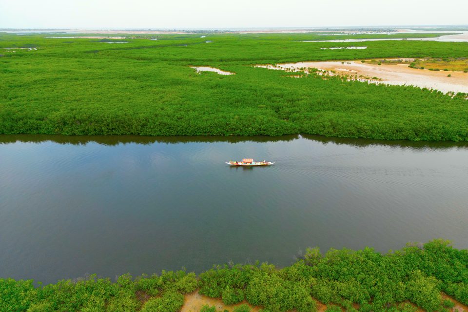
A bolon, one of the delta's brackish channels, from the air.
Photograph: Issiaga0 · CC BY-SA 4.0 · cropped
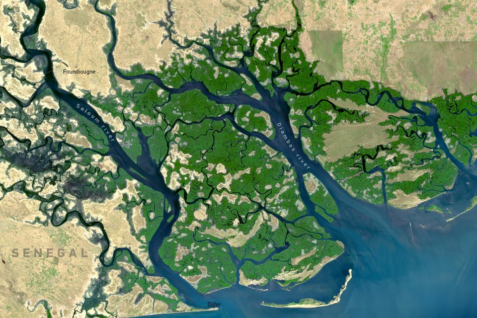
Satellite image of the delta, 11 February 2024 (Copernicus Sentinel-2).
Satellite image: Contains modified Copernicus Sentinel data 2024 · Copernicus data licence · cropped
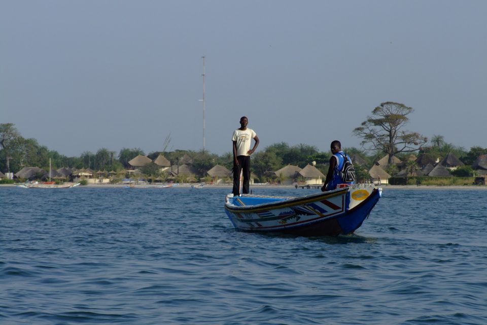
A pirogue off Dionewar, one of the delta's island villages.
Photograph: arno B · Ile du saloum DINOUAR - panoramio · CC BY 3.0 · cropped
- Go out by pirogue, and ask to be shown a mound with a baobab on it.
- Ask which mounds are graves. Look at those from the boat.
- Eat grilled oysters somewhere with a view of the mangrove.
- Watch the women on the mudflats from a distance. They are at work.
- Pick up one shell, look at it, and put it back. It is somebody’s dinner.
A baobab on a heap of shells. Out in the mangrove, a single enormous tree stands on a low island whose ground crunches underfoot, pale with broken cockle and oyster. The tree is there because the island is; the island is there because people ate here, and threw the shells down, and kept doing it for two thousand years. On some of these islands the heap was later used to bury the dead. The tree is the easiest way to find one.
Tally, in the marginOne tree on a heap of old dinners, marking the spot for anyone who knows how to read it. I did not, until I was told, and now I cannot see a baobab without wondering what is underneath it.
Getting there
How to get there. Fly into Dakar’s Blaise Diagne International Airport, then go south by road. The usual bases on the delta’s edge — Ndangane and Palmarin in the north, Foundiougne on the Saloum, Toubacouta in the south — are roughly three to four hours’ drive, depending on which and on the traffic leaving Dakar. Hired cars with drivers and shared bush taxis both make the trip.
On the water. The delta is travelled by pirogue, the long painted wooden boat of the Senegalese coast, hired with a boatman from any of those bases, for a half-day or a full day among the bolons. Many of the island villages have no road at all. Ask specifically to see a shell mound and a baobab on one; boatmen from Toubacouta and Dionewar know which are open to visitors and which are burial grounds to be seen from the boat.
When to go. November to May, the dry season, is the comfortable time and the time the women are out on the mudflats, which runs from December to June. The rains come from roughly July to October; the delta is at its greenest and the tracks at their worst.
Where to stay. Small lodges and campements, many of them reachable only by boat, on Mar Lodj and around Toubacouta, Ndangane and Palmarin. Book the transfer when you book the bed.
What to bring. Cash in West African CFA francs; card payment thins out quickly south of Dakar. Something to cover your head on the water. And a willingness to eat grilled oysters out of the shell, which is the most direct way available to take part in the site’s central tradition.
Mark this place
Common questions
What are the shell mounds of the Saloum Delta?
They are middens: heaps of discarded cockle and mangrove oyster shells accumulated by the people of the Saloum Delta in Senegal over more than two thousand years. The 1997 Thilmans inventory records 218 of them within the UNESCO property, grouped in 96 sites. The largest, such as Dioron Boumak and Ndiamon-Badat, are several hundred metres long and up to eight to twelve metres high.
How old are the Saloum shell mounds?
Radiocarbon dating puts the oldest mounds in the Saloum Delta at around 400 BC, according to the ICOMOS evaluation prepared for UNESCO in 2011. Burial tumuli were added on top of some mounds from the eighth century AD through to the sixteenth. UNESCO describes the accumulation as a cultural process lasting two thousand years.
Are the islands in the Saloum Delta man-made?
Some are. ICOMOS describes the Saloum Delta shell mounds as having formed man-made islets, and considers their placement deliberate: shells were piled so as not to block the delta’s channels and to create dry ground in land that floods. Most of the delta’s more than two hundred islands are natural mangrove and sand, and the shell-mound islets are scattered among them.
Why are there baobabs on the Saloum shell mounds?
Baobabs grow on the raised, dry ground of the Saloum Delta’s shell mounds and not in the surrounding mangrove, which makes them a visible marker of where the mounds are. ICOMOS notes that the mounds are clearly identifiable on satellite images. On Dioron Boumak a ring of baobabs forms the tomb of the Wolof griot Bak Kawl.
Are people buried in the Saloum shell mounds?
Yes. Twenty-eight of the Saloum Delta’s 218 shell mounds carry burial tumuli, low shell cairns over one or more individuals, and more than nine hundred tumuli have been identified. Tioupane near Falia has 222, Ndiamon-Badat 149 and Dioron Boumak 125. ICOMOS reports that rites and prohibitions attached to these burial grounds are occasionally still observed.
Were the Saloum shell mounds damaged?
Yes. From the late nineteenth century through the twentieth, Saloum Delta shell mounds were quarried by canoe for lime kilns, concrete aggregate and fill. ICOMOS records at least twenty intensively exploited and one, Baboura, destroyed. Extraction is now banned, though the 2011 ICOMOS evaluation reported that illegal digging appeared to continue.
Who harvests shellfish in the Saloum Delta today?
Women. In the Saloum Delta the gathering and processing of cockles and mangrove oysters is done by women during the dry season, December to June, using dugout canoes, plant-fibre baskets and knives, while men fish. ICOMOS notes that when this division of labour began is not known. Harvest zones and seasons are managed so that shellfish beds recover.
How big is the Saloum Delta?
It depends which Saloum Delta is meant. The UNESCO World Heritage property is 145,811 hectares with a 78,842-hectare buffer zone, although UNESCO’s short description gives 5,000 square kilometres. Saloum Delta National Park, created in 1976, covers about 76,000 hectares, and the delta as a whole is given as around 180,000 hectares.