
- Where
- South Shetland Islands
off the Antarctic Peninsula - Coordinates
- 62.9500° S
60.6333° W - Biome
- Volcanic ash and glacier;
geothermal ground, moss and lichen - The island
- About 15 km across, 98.5 km²
highest point 539 m - Last eruptions
- 1967, 1969 and 1970
- Status
- Antarctic Specially Managed Area No. 4
- Best visited
- November–March, the austral summer
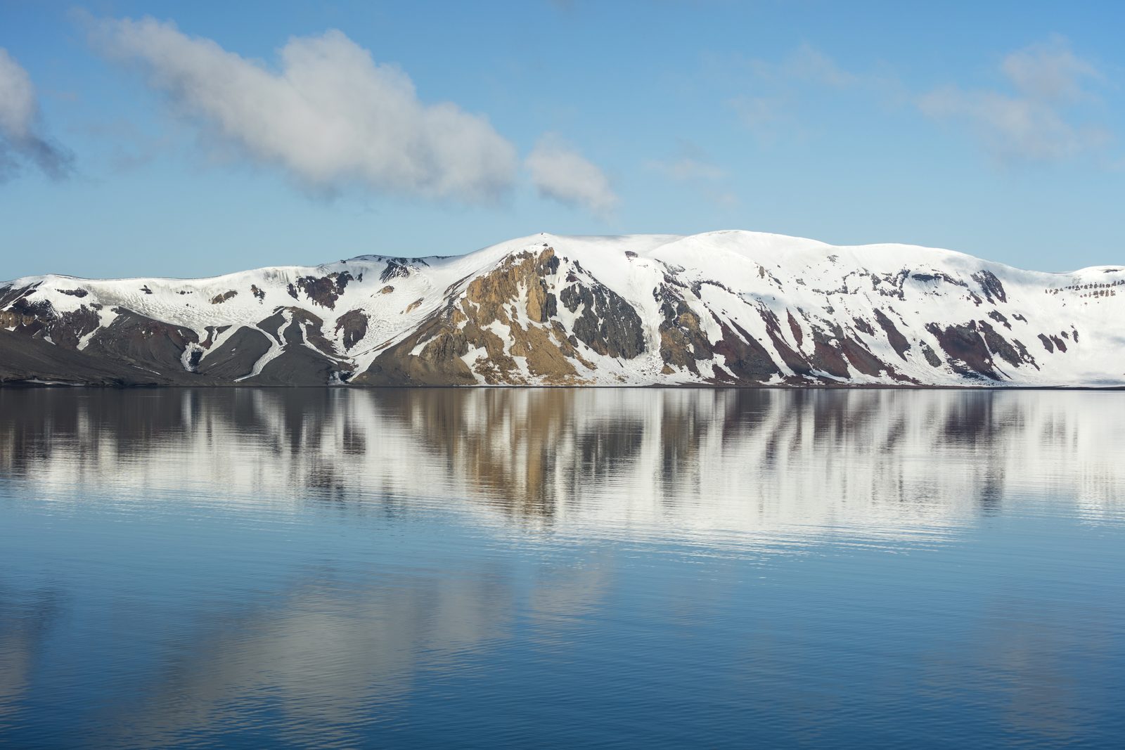
Sailed straight at a black cliff until a gap opened in it, and came through into a round grey lake that was really the sea, ringed by ash hills striped with old ice. Rusted tanks along the beach, a house with its middle torn out, penguins walking past the wreckage as though it belonged to them. The sand at the waterline was warm, and in places it steamed. Several people went swimming. I held their towels, which is also a way of taking part.
The short answer
Deception Island lies in the Bransfield Strait in the South Shetland Islands, off the Antarctic Peninsula. It is the exposed top of an active volcano: a ring of land about fifteen kilometres across, 98.5 square kilometres in area and over half covered in glacier, rising to 539 metres at Mount Pond. The sea has flooded the collapsed centre to form Port Foster, a bay about ten kilometres long and seven wide, entered through a single narrow channel called Neptune’s Bellows. Its shelter made it the base of a whaling industry from 1906 to 1931 and later of British, Argentine and Chilean stations, until eruptions in 1967, 1969 and 1970 destroyed or drove out the stations then operating. Argentina and Spain run summer research stations there today, and it is among the most visited sites in Antarctica.
Why it's worth knowing
The American sealer Nathaniel Palmer, who explored it in November 1820, named it for its disguise. From outside it looks like an ordinary island. Only when you find the gap do you learn that it is a ring around water.
That disguise is also its value. In an ocean with no shelter, a harbour enclosed by land on almost every side, with a flat floor and little ice, is worth a great deal. Sealers used it within months of its discovery. Whalers built an industry in it. Navies and governments contested it. A great many people worked here in safety for decades, and the thing keeping them safe was the crater of a volcano.
The volcano is not extinct. Around ten thousand years ago an explosive eruption emptied roughly thirty cubic kilometres of molten rock from beneath the island and the summit collapsed to form the caldera. It was active through the eighteenth and nineteenth centuries, and in the twentieth erupted in two short periods, 1906–1910 and 1967–1970. The floor of Port Foster is rising rapidly in geological terms. The Deception Island Management Group classifies it as a restless caldera with significant volcanic risk and publishes a live alert level, whose normal state is green.
So the safest harbour in the South Shetlands is inside one of the most active volcanoes in Antarctica. Both descriptions are accurate. Every visitor who comes in through the Bellows is taking part in the same bargain the whalers made.
The field notes
Whalers Bay
Just inside the Bellows is Whalers Bay, a black-sand cove where most landings happen. Whaling here began in 1906, when a Chilean-Norwegian company, the Sociedad Ballenera de Magallanes, moored a factory ship in the harbour. Others followed, with several hundred men resident in the summers and as many as thirteen ships in peak years.
A Norwegian company, Hvalfangerselskabet Hektor, then built a shore station to process the carcasses the factory ships could not use, and it ran until 1931, when pelagic factory ships that could haul whole whales aboard made shore stations uneconomic. Its construction date differs between sources: 1912 in one account and 1905 in the Management Group’s own history. Its rusting boilers and tanks still line the beach.
The whalers’ cemetery held the graves of thirty-five men and a memorial to ten more presumed drowned; it was buried by the mudflows of 1969. The remains at Whalers Bay, including the later British station, are protected as Historic Site and Monument No. 71.
1967 to 1970
By the 1960s there were three stations on the shores of Port Foster: British, Argentine and Chilean. In December 1967 an eruption forced all of them to evacuate. The Chilean station at Pendulum Cove was destroyed.
The British returned to Station B at Whalers Bay in December 1968. In February 1969 renewed eruptions sent mudflows of meltwater and ash through the bay, tearing the middle out of the station house, Biscoe House, and burying the cemetery; the station was abandoned. In August 1970 a further eruption dropped ash on stations on neighbouring islands.
The station house still stands with its centre torn out, and it is one of the most direct demonstrations anywhere of what the harbour’s owner can do.
The first flight in Antarctica
On 16 November 1928, during the Wilkins-Hearst expedition, the Australian explorer Hubert Wilkins took off from a beach airstrip on Deception Island in a Lockheed Vega — the first successful powered flights in Antarctica.
An aircraft hangar also stands at Whalers Bay among the ruins. The Antarctic was first seen from the air from this harbour, for the same reason everything else happened here: it was the one place for hundreds of kilometres where you could safely keep a machine on the shore.
Steam at the tideline
The volcano is most obvious at the waterline. At several beaches inside Port Foster, geothermal heat warms the sand and the shallows, and steam rises off the shore in cold air. The Management Group records temperatures of 70°C around fumaroles and heated water.
The heat makes the island biologically unusual. Its geothermal ground supports at least eighteen species of moss or lichen recorded nowhere else in the Antarctic, two found only here, and the largest known community of Antarctic pearlwort. Eleven sites are protected as Antarctic Specially Protected Area No. 140, including Kroner Lake, described as the only geothermal lagoon in the Antarctic, and Telefon Bay, whose surfaces all date from 1967 and are being colonised afresh.
It also makes possible the thing many visitors come for: a swim in Antarctica in water that, in places, is warm. Expedition operators organise it at designated beaches, and the unwritten rule is that the brave go in and everybody else holds the towels.
Baily Head, and a superlative declined
On the island’s outer coast, at Baily Head, a very large colony of chinstrap penguins nests on the slopes of a natural amphitheatre. The Deception Island Management Group describes it as the world’s largest chinstrap colony, of an estimated 100,000 pairs, and BirdLife International gives the same number.
This entry does not repeat the superlative. Two studies published in Polar Biology in 2012 — one by Barbosa and colleagues, and the first direct site-wide survey of the island by Naveen and colleagues — both reported significant declines in breeding chinstraps on Deception. The colony is still very large. Whether it is still the largest is not something the published sources consulted here establish.
Landings at Baily Head are made through surf on an exposed beach and are cancelled often. The Management Group’s count for 2023–24 was almost a thousand people landed there, against over 25,000 at Whalers Bay.
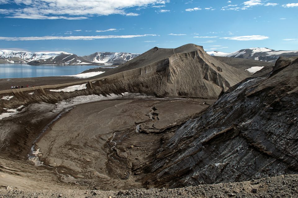
Ash slopes inside the caldera.
Photograph: Christopher Michel · DECEPTION ISLAND · CC BY 2.0 · cropped
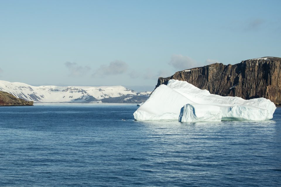
Neptune's Bellows, the only way in or out.
Photograph: Andrew Shiva / Wikipedia · CC BY-SA 4.0 · cropped
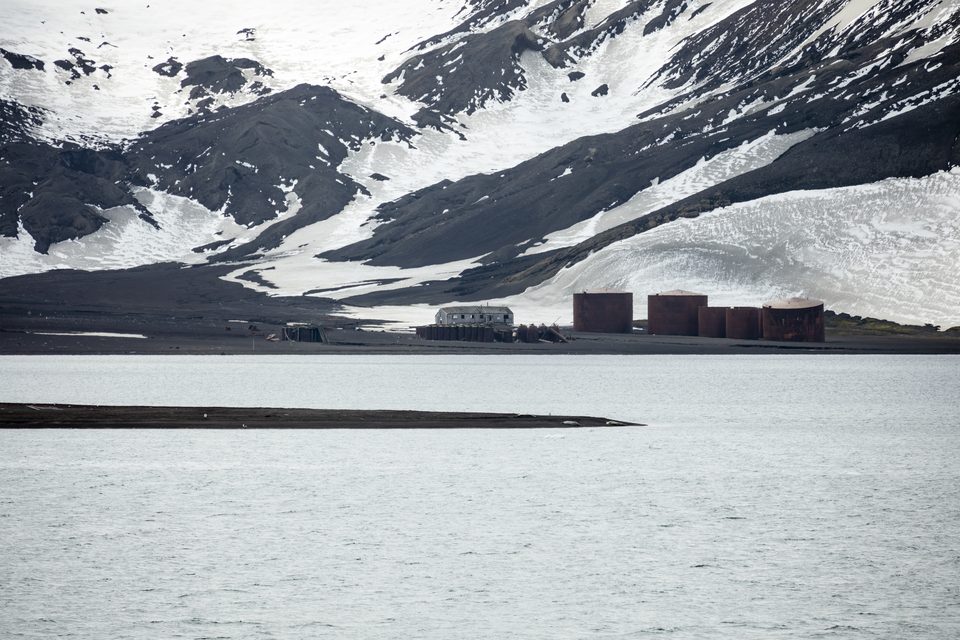
The whaling station tanks at Whalers Bay.
Photograph: Andrew Shiva / Wikipedia · CC BY-SA 4.0
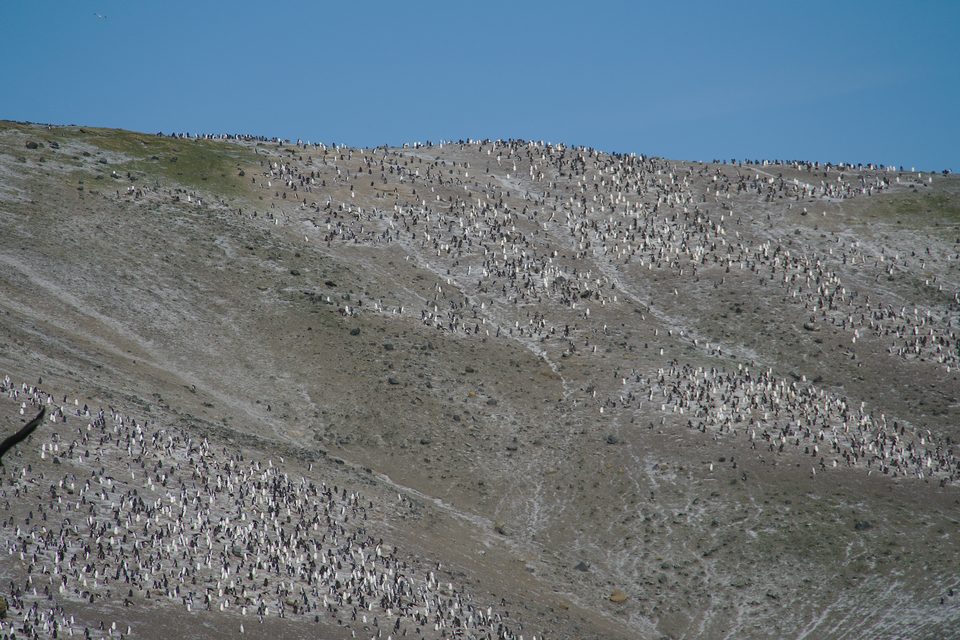
Chinstrap penguins at Baily Head.
Photograph: mike from New York, NY, US · Baily Head, Deception Island (40326006883) · CC BY-SA 2.0 · cropped
- Be on deck for the gap in the cliffs. It is over quickly.
- Put a hand in the shallows at the tideline. Carefully.
- Look at the torn house for a long time before you photograph it.
- Swim, or hold the towels. Both count. (Item retained.)
- Do not step inside anything the whalers built.
A beach that steams. At the edge of Port Foster, on a cold grey morning with snow on the hills behind, wisps of vapour rise off the black sand where the water laps it. Dig a hand into the shallows and it is warm; in places, near the vents, it is far too hot to touch. It is the volcano, breathing through the beach, and it is the same heat that let rare mosses grow here and that, in 1969, sent mud through the station house a few hundred metres away.
Tally, in the marginWarm sand on a cold morning in the far south, and the reason is that the ground underneath is not finished. I sat on it anyway. So, I noticed, did everybody else.
Getting there
How to get there. On an expedition ship. Almost all visits are on Antarctic Peninsula cruises from Ushuaia in Argentina, which cross the Drake Passage in about two days each way, or on fly-cruise itineraries that fly from Punta Arenas in Chile to King George Island and board a ship there. Deception is a common stop on South Shetland itineraries, but it is never guaranteed: weather and ice decide.
When to go. The Antarctic season runs from about November to March. Early-season visits find more snow and ice on the island; later ones find more bare ash and more penguin chicks.
Where you land. Visitor landings are made at Whalers Bay, Telefon Bay, Pendulum Cove and Baily Head, each governed by Antarctic Treaty site guidelines and the island’s management plan. Whalers Bay is the most visited landing site on the island. Stay on the routes you are given, do not enter the ruined buildings, and do not touch the historic remains.
Booking. Expedition cruises book up six months to a year ahead for the best cabins, and prices vary widely with ship size and route. If Deception matters to you, ask the operator how often their itinerary has actually made the landing in recent seasons.
Practical notes. There are no consular services anywhere in Antarctica and very limited medical care; your ship is your hospital. Travel insurance with evacuation cover is required by most operators. Bring swimwear if you intend to swim, and a towel if you intend to hold one.
Mark this place
Common questions
Why is it called Deception Island?
Because from the sea it looks like an ordinary island. The American sealer Nathaniel Palmer, who explored it in November 1820, named it for that disguise: only through the narrow channel of Neptune’s Bellows does it become clear that Deception Island is a ring of land around a flooded volcanic caldera, the sheltered bay now called Port Foster.
Is Deception Island an active volcano?
Yes. Deception Island in the South Shetlands is the caldera of an active volcano that erupted in 1967, 1969 and 1970, destroying or forcing the abandonment of the research stations then on the island. The Deception Island Management Group classifies it as a restless caldera with significant volcanic risk and publishes a volcanic alert level, normally green.
What is at Whalers Bay on Deception Island?
The remains of the whaling industry that used Deception Island from 1906 to 1931, including the boilers and tanks of the Norwegian Hektor shore station, and the later British Station B, whose main house was torn open by mudflows in 1969. An aircraft hangar also stands there. The whalers’ cemetery was buried by the same mudflows. The site is Antarctic Historic Site and Monument No. 71.
Can you swim at Deception Island?
Yes, at designated beaches inside Port Foster where geothermal heat warms the shallows. Expedition operators organise swims as part of landings. The Deception Island Management Group records temperatures of up to 70°C around fumaroles and heated water, so the water can vary sharply over short distances and visitors should follow their guides’ instructions.
Who owns Deception Island?
No one exercises undisputed sovereignty. Argentina, Chile and the United Kingdom have all claimed the island, and it is governed under the Antarctic Treaty System as Antarctic Specially Managed Area No. 4, overseen by a management group of treaty parties. Argentina and Spain operate summer research stations there: Decepción Station, founded in 1948, and Gabriel de Castilla, built around 1989–90.
What was the first flight in Antarctica?
On 16 November 1928, during the Wilkins-Hearst expedition, Hubert Wilkins flew a Lockheed Vega from a beach airstrip on Deception Island, in the first successful powered flights in Antarctica. Deception Island’s sheltered harbour made it one of the few places in the region where an aircraft could be kept safely on shore.
Does Deception Island have the world’s largest chinstrap penguin colony?
It is often said to. The Deception Island Management Group and BirdLife International both give Baily Head about 100,000 breeding pairs of chinstrap penguins and the Management Group calls it the largest colony in the world. Two studies published in Polar Biology in 2012 reported significant declines in breeding chinstraps on Deception, so the superlative is not repeated here as settled.
How do you get to Deception Island?
By expedition ship during the austral summer, from November to March. Most voyages leave from Ushuaia in Argentina and cross the Drake Passage in about two days; fly-cruises fly from Punta Arenas, Chile, to King George Island and board there. Landings at Deception Island depend on weather and ice and are not guaranteed on any itinerary.