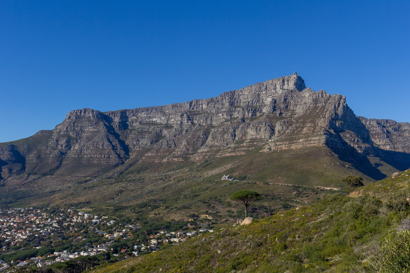

- Where
- Above Cape Town
Western Cape, South Africa - Coordinates
- 33.9622° S
18.4099° E - Highest point
- 1,086 m
at Maclear’s Beacon - Plateau
- About 3 km
from side to side - In the sky
- Mensa, named by Lacaille
in 1756 - Status
- UNESCO World Heritage 2004
Cape Floral Region - Cableway
- Opened 4 October 1929
Went up a grey face of rock with a flat top, the city and harbour spread round its feet, the wind coming at me sideways. On the flat were shrubs and flowers I had no names for, and a small furry creature sunbathing as if it paid rent. Then a white cloud came pouring over the edge like a cloth being laid, and I sat still until it had finished.
The short answer
Table Mountain is the flat-topped mountain that stands directly above Cape Town, at the northern end of the sandstone range that runs down the Cape Peninsula to the Cape of Good Hope. Its level plateau is about three kilometres across, edged with cliffs, with Devil’s Peak to the east and Lion’s Head to the west; its highest point, Maclear’s Beacon, is 1,086 metres above sea level. It lies in Table Mountain National Park, run by South African National Parks (SANParks), and its plants belong to the Cape Floral Region Protected Areas, inscribed by UNESCO in 2004. Wikipedia’s account says the mountain is part of lands formerly inhabited by Khoe-speaking clans, and gives a Khoe name for it, Huriǂoaxa, “sea-emerging”. The Portuguese navigator António de Saldanha made the first recorded ascent in 1503 and called it Taboa do Cabo, the Table of the Cape.
Why it's worth knowing
Nicolas-Louis de Lacaille came to the Cape of Good Hope in 1750 to observe the southern sky and built an observatory on the shore of Table Bay. Between 1751 and 1752 he recorded nearly 10,000 southern stars, and to organise the parts of the sky that no European constellation covered he invented fourteen new ones. Wikipedia notes that thirteen of them honour instruments of the Enlightenment, among them the telescope, the microscope and the air pump. The fourteenth honours the mountain he worked beneath.
Ian Ridpath, the historian of the constellations, records that Lacaille first called it Montagne de la Table on his planisphere of 1756 and Latinised it as Mons Mensae in the second edition of 1763; John Herschel proposed shortening it to Mensa in 1844, and it has been Mensa since Francis Baily adopted the name in 1845. Wikipedia describes it as the only constellation named after a feature on Earth.
Lacaille gave his mountain its cloud as well. Part of the Large Magellanic Cloud, a neighbouring galaxy, lies within Mensa, so that, as Ridpath puts it, the constellation appears capped by a white cloud like the tablecloth sometimes seen over the mountain itself. Wikipedia adds that Lacaille remembered the mountain’s cloud when the south-easterly wind blew. Mensa is also the faintest constellation in the sky, by Wikipedia’s account: its brightest star is barely visible from a suburb.
The field notes
The tablecloth
When a south-easterly wind drives moist air up the mountain’s slopes into colder air, the moisture condenses into a sheet of cloud that spills over the edge of the plateau: the tablecloth. Cape Town’s folklore, as Wikipedia recounts it, blames a smoking contest between the Devil and a pirate called Van Hunks. SANParks warns that the weather on the mountain is unpredictable and can change suddenly, with loss of visibility, and the cableway closes in strong wind.
A valley floor on top
The mountain is flat because it was once low. Wikipedia’s account of its geology describes it as a syncline, the trough of a fold: the high ground of the fold lay to the east and has worn away, with the softer rocks beneath it, to leave the low Cape Flats, while the hard quartzitic sandstone of the old valley floor has stayed standing as the plateau. The upper 600 metres or so are Ordovician rock, 450 to 510 million years old: grey Table Mountain Sandstone over a thinner band of maroon mudstone laid down on tidal flats, the whole resting on Cape granite.
More kinds of plant than Britain
Wikipedia’s account gives about 2,285 plant species on the Cape Peninsula’s mountains, and 1,500 of them on the 57 square kilometres of Table Mountain and the Back Table: at least as many, it says, as in the whole of the United Kingdom. Most are fynbos, the fine-leaved shrubland adapted to fire that is found only in the Cape. UNESCO describes the Cape Floral Region as one of the world’s great centres of terrestrial biodiversity. The mountain also has a frog found nowhere else, the Table Mountain ghost frog.
The cableway
The Table Mountain Aerial Cableway opened on 4 October 1929. The cableway company’s own account says its Rotair cars climb 704 metres, from the lower station at 363 metres above sea level to the upper station at 1,067 metres, and that their floors rotate so that every passenger sees the whole view on the way. Wikipedia gives the lower station as about 302 metres; this entry uses the company’s figure.
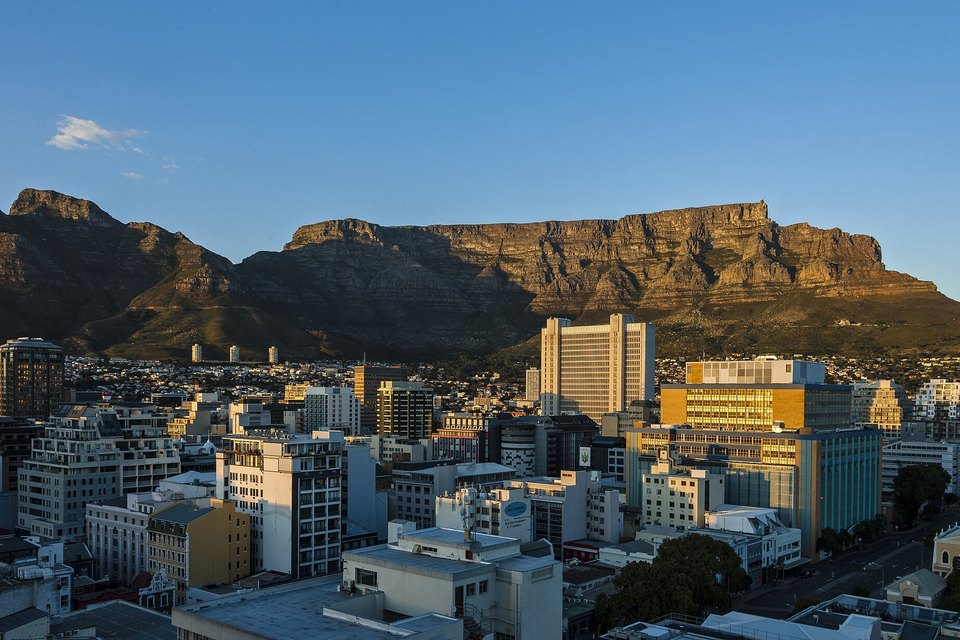
The city bowl beneath the mountain's north face at dawn, July 2018.
Photograph: Daniel Case · Cape Town City Bowl and Table Mountain at dawn · CC BY-SA 3.0 · cropped
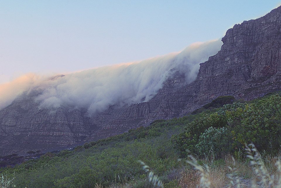
The 'tablecloth': cloud spilling over the plateau edge, November 2000 (film photograph).
Photograph: KodachromeFan · Cape Town, Table Mountain, Table Cloth · CC BY-SA 3.0
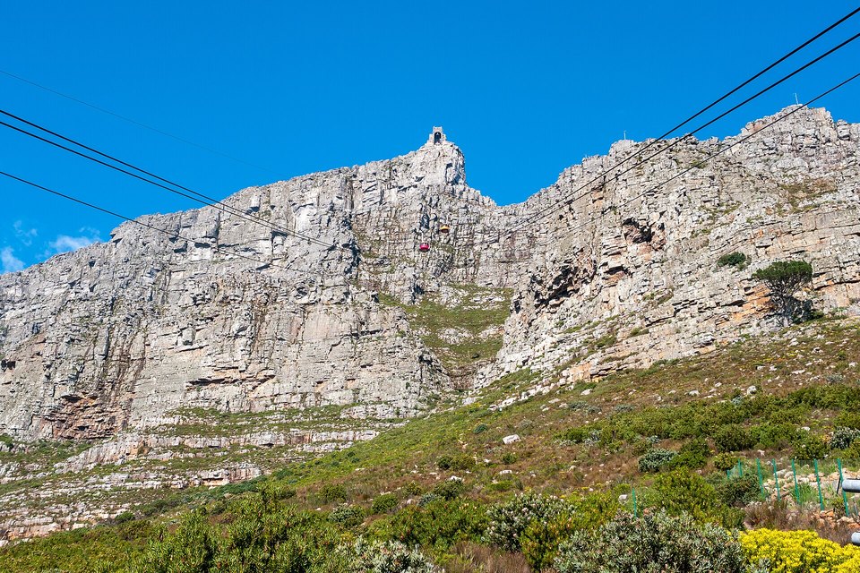
A cableway car climbing the north face to the upper station, July 2018.
Photograph: Matti Blume · CC BY-SA 4.0 · cropped
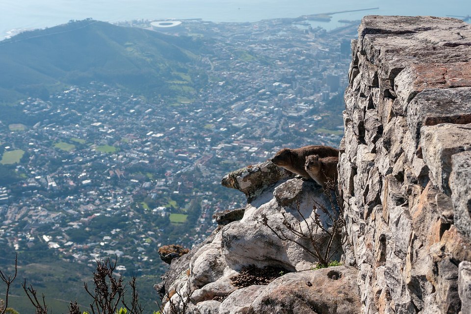
Rock hyraxes (dassies) on the summit edge, high above the city, July 2018.
Photograph: Matti Blume · CC BY-SA 4.0 · cropped
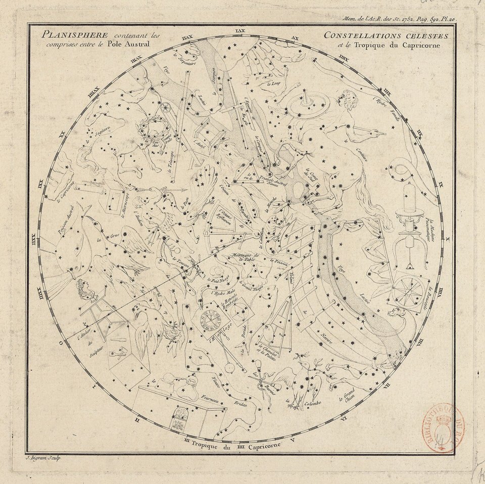
Lacaille's planisphere of the southern sky, printed in 1756 in the Académie royale des sciences' Mémoires for 1752: the mountain's first appearance as a constellation, \"Montagne de la Table\" (historic chart).
Photograph: Nicolas-Louis de Lacaille, engraved by J. Ingram (Bibliothèque nationale de France) · Public domain
- Look at the top before you look at the queue. If the cloth is on, have breakfast and wait.
- Carry a warm layer up on the hottest day, and start down while there is plenty of light left.
- Walk up at least one way, slowly, and learn the name of one plant properly.
- Keep to the path and leave every flower where it is. The top is theirs.
- Keep the list out of the wind at the top. (Failed. Two items are somewhere over the city, and I hope whoever finds them does them properly.)
A piece of grey Table Mountain Sandstone. The hard, quartzitic sandstone of the plateau was once the floor of a valley. The mountain is a syncline, the trough of a fold: the high ground of the fold lay to the east and has worn away, with the softer rocks beneath it, to leave the low Cape Flats, while the old valley floor has stayed standing as the flat top. The upper 600 metres or so are Ordovician rock, 450 to 510 million years old, grey sandstone over a thinner band of maroon mudstone. When the south-easterly blows, the tablecloth is laid across it.
Tally, in the marginA tabletop that used to be a floor. I sat on it for most of an afternoon while the cloth was laid, and nobody came to dinner. I stayed anyway, in case.
Getting there
How to get there. Fly to Cape Town. The cableway’s lower station is on Tafelberg Road, on the city side of the mountain. Tickets are sold online and at the ticket office. The cableway can close in bad weather, and the company notes that when it reopens after a closure only ticket-holders are admitted.
Walking up. Platteklip Gorge, up the middle of the front face, is the direct route: about two and a half hours in Wikipedia’s account, steep and almost without shade. Longer routes start from Kirstenbosch National Botanical Garden on the southern side. SANParks advises keeping to well-used paths; carrying water, food, a hat, sunblock and warm windproof clothing even on hot days; turning back if the weather threatens; and allowing time to walk down, because the cableway can shut unexpectedly and leave walkers stranded at the top in the dark. It lists (021) 957 4700 and (021) 480 7700 as emergency numbers to save before a hike.
When to go. Look at the top before you set out. SANParks warns that Platteklip Gorge can be extremely hot, and that the top can be much colder and windier than the city below, with an icy wind even in January and February.
Safety. The State Department has South Africa at Level 2, exercise increased caution, because of crime, terrorism, civil unrest and kidnapping. It advises visitors not to walk alone, especially after dark, and to stay alert at tourist spots.
Mark this place
Common questions
Why is Table Mountain flat?
Table Mountain in Cape Town is flat because it was once the floor of a valley. It is a syncline, the trough of a fold in the rock: the higher ground of the fold has worn away, while the hard, erosion-resistant quartzitic Table Mountain Sandstone of the old trough has remained as a level plateau about three kilometres across.
Is there a constellation named after Table Mountain?
Yes. The constellation Mensa is named after Table Mountain. The French astronomer Nicolas-Louis de Lacaille, who catalogued southern stars from Cape Town in 1751–52, called it Montagne de la Table in 1756 and Mons Mensae in 1763; it was shortened to Mensa in the 1840s. Wikipedia describes it as the only constellation named after a feature on Earth.
How high is Table Mountain?
The highest point of Table Mountain, Maclear’s Beacon at the eastern end of the plateau, is 1,086 metres above sea level. The upper station of the Table Mountain Aerial Cableway, at the western end, is at 1,067 metres. The mountain rises about a kilometre above Cape Town.
What is the Table Mountain tablecloth?
The tablecloth is the sheet of cloud that forms over the flat top of Table Mountain in Cape Town when a south-easterly wind pushes moist air up its slopes into colder air, where the moisture condenses and spills over the cliffs. Local folklore attributes it to a smoking contest between the Devil and a pirate named Van Hunks.
How long does it take to hike up Table Mountain?
The most direct route up Table Mountain, Platteklip Gorge, takes about two and a half hours, climbing steeply with almost no shade. SANParks advises hikers to carry water, food and warm windproof clothing, to stay on well-used paths, and to leave time to walk down, because the cableway can close suddenly in bad weather.
When did the Table Mountain cableway open?
The Table Mountain Aerial Cableway in Cape Town opened on 4 October 1929. Its current Rotair cars, whose floors rotate during the ride, climb 704 metres from the lower station at 363 metres above sea level to the upper station at 1,067 metres, according to the cableway company.
How many plant species grow on Table Mountain?
About 1,500 plant species grow on the 57 square kilometres of Table Mountain and the Back Table in Cape Town, by Wikipedia’s account at least as many as in the whole of the United Kingdom, and about 2,285 on the Cape Peninsula’s mountains. Most are fynbos. They are part of the Cape Floral Region Protected Areas, a UNESCO World Heritage Site since 2004.
Who first climbed Table Mountain?
The first recorded ascent of Table Mountain was by the Portuguese navigator António de Saldanha in 1503, by way of Platteklip Gorge; he named the mountain Taboa do Cabo, Table of the Cape. The land had long been home to Khoe-speaking clans, whose name for the mountain Wikipedia gives as Huriǂoaxa, “sea-emerging”.