
- Where
- Ounila valley, Ouarzazate
province, Morocco - Coordinates
- 31.047° N
7.129° W - Built of
- Rammed earth, adobe,
clay brick and wood - Oldest buildings
- None earlier than
the 17th century (UNESCO) - Status
- UNESCO World Heritage,
1987 - Residents
- A few families in the ksar;
most across the river - 2023 earthquake
- Slight overall (UNESCO);
a granary collapsed
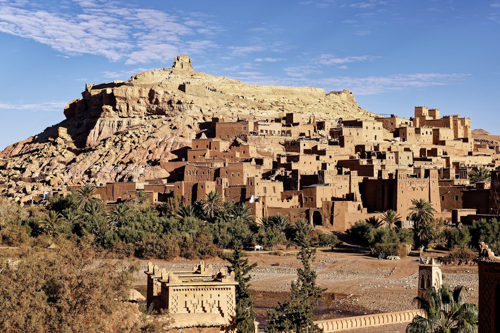
A village the colour of the hill it stood on, climbing the slope in towers and walls of mud and straw, a ruined store at the very top. Palms along a stony riverbed, snow far off on the mountains. The gate turned me one way, then the other, before letting me in. Someone had patched a wall with fresh mud, still dark, and I was glad of it.
The short answer
Aït Benhaddou is a ksar, a fortified village, on the slope of a hill beside the Ounila River in Ouarzazate province, southern Morocco, on the southern side of the High Atlas. UNESCO, which inscribed it in 1987, describes it as a group of earthen buildings surrounded by high walls, a traditional pre-Saharan settlement and a striking example of the architecture of southern Morocco: houses crowded inside defensive walls reinforced with corner towers and entered by a baffle gate, some of them modest, others like small castles, with their upper parts decorated in brick. UNESCO says the oldest buildings do not appear to be earlier than the 17th century, though the way they are built is far older. Wikipedia’s account says the site has been fortified since the 11th century, and that it stood on one of the caravan routes across the mountains between the Sahara and Marrakesh.
Why it's worth knowing
An earth village has to be rebuilt to stay standing. Wikipedia’s account of the ksar explains that its rammed earth, mixed with straw, is permeable and easily eroded by rain, and that villages of this kind can begin to crumble only a few decades after they are abandoned; the taller buildings are rammed earth to the first floor and lighter adobe above. UNESCO’s state-of-conservation reports name the problem plainly: the earthen buildings are very vulnerable to a lack of maintenance and regular repair that follows from the ksar’s abandonment by its inhabitants. One of them puts the stakes: earth architecture of this kind can last for centuries if it is regularly looked after, and may collapse within a few decades if it is not.
The people who mend it have mostly moved out. Wikipedia says that only a few families still live in the ksar and that most local people now live in the modern village on the other side of the river, making a living from farming and, above all, from visitors. A pedestrian bridge completed in 2011 joins the two, partly in the hope of drawing residents back. The ksar has been restored, Wikipedia says, thanks in part to its use as a film location and in part to its inscription by UNESCO, and it has kept its authenticity, in UNESCO’s words, by continuing to use traditional materials and techniques and largely avoiding concrete.
The field notes
A set that is a village
The film list is long. Wikipedia’s includes Lawrence of Arabia (1962), The Man Who Would Be King (1975), Jesus of Nazareth (1977), The Jewel of the Nile (1985), The Living Daylights (1987), The Mummy (1999), Gladiator (2000), Kingdom of Heaven (2005) and Prince of Persia (2010), as well as parts of the television series Game of Thrones. Visitors who have never been to Morocco have often seen the ksar several times, dressed as somewhere else.
The earthquake
The earthquake of 8 September 2023, centred in the High Atlas in Al Haouz province, killed 2,960 people by Wikipedia’s count and damaged many historic sites. Wikipedia reports an early assessment at Aït Benhaddou of cracks and partial collapses. UNESCO’s 2024 state-of-conservation report, drawing on a technical assessment by CERKAS, Morocco’s heritage conservation centre for the Atlas and sub-Atlas regions, found the property only slightly affected compared with other sites, and buildings restored with traditional techniques had generally withstood the shaking. But seven buildings were damaged to varying degrees, among them the Ait Ougram and N’Oumghar kasbahs; a granary, the grenier des Potiers, the only surviving evidence of a collective granary, collapsed with three of the five towers of its wall; and there were rockfalls in the south-west of the property. A programme to restore houses in the ksar, begun in 2014 and slowed by the pandemic, was to resume and take in some of the newly damaged buildings. In 2026 Hespress reported tenders for laying out two squares at the ksar for exhibitions and cultural events. At the time of writing, the sources we could reach did not say which damaged buildings had been repaired.
The granary at the top
Wikipedia describes the remains of a large fortified granary, an agadir, at the top of the hill above the ksar, with a mosque, a caravanserai, several kasbahs, a public square and Muslim and Jewish cemeteries below it, and an area outside the walls where grain was grown and threshed. Whether the granary UNESCO reports lost in 2023 is this one, the sources we could reach do not say.
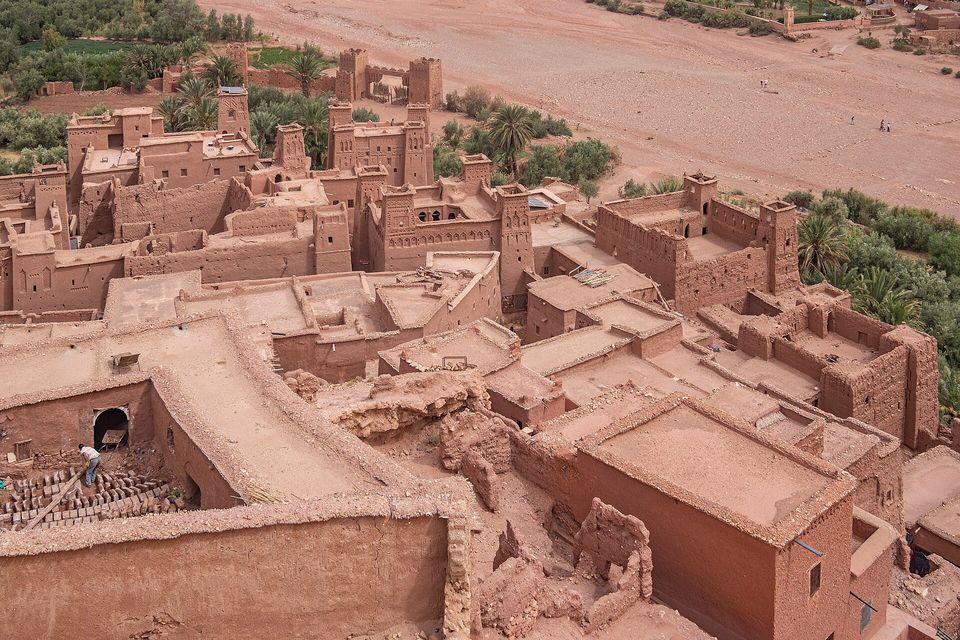
Rooftops of the ksar seen from above, with rows of mud bricks laid out to dry at lower left, July 2019.
Photograph: C messier · CC BY-SA 4.0
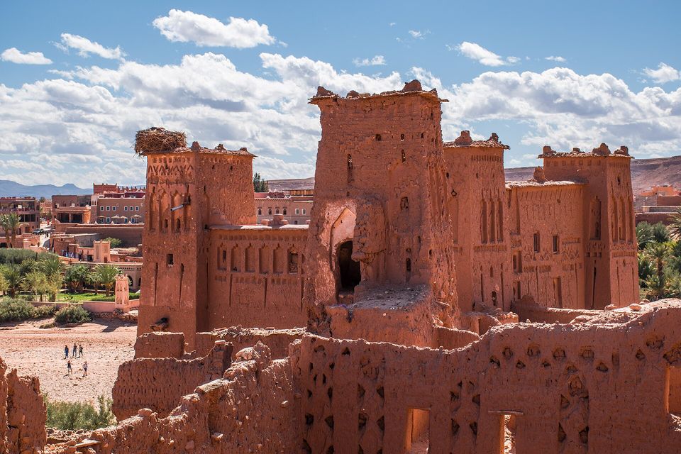
Decorated tower houses inside the ksar, a stork's nest on the left-hand tower, the modern village beyond, October 2018.
Photograph: Ralf Steinberger · Kasbah of the abandoned town Ait Benhaddou in Southern Morocco · CC BY 2.0
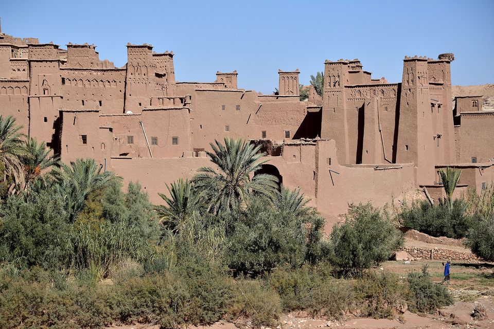
Tower houses along the ksar's lower wall, seen from the riverbed, November 2016.
Photograph: ER Bauer · Kasbah Ait Benhaddou, Morocco (29) · CC BY-SA 2.0 · cropped
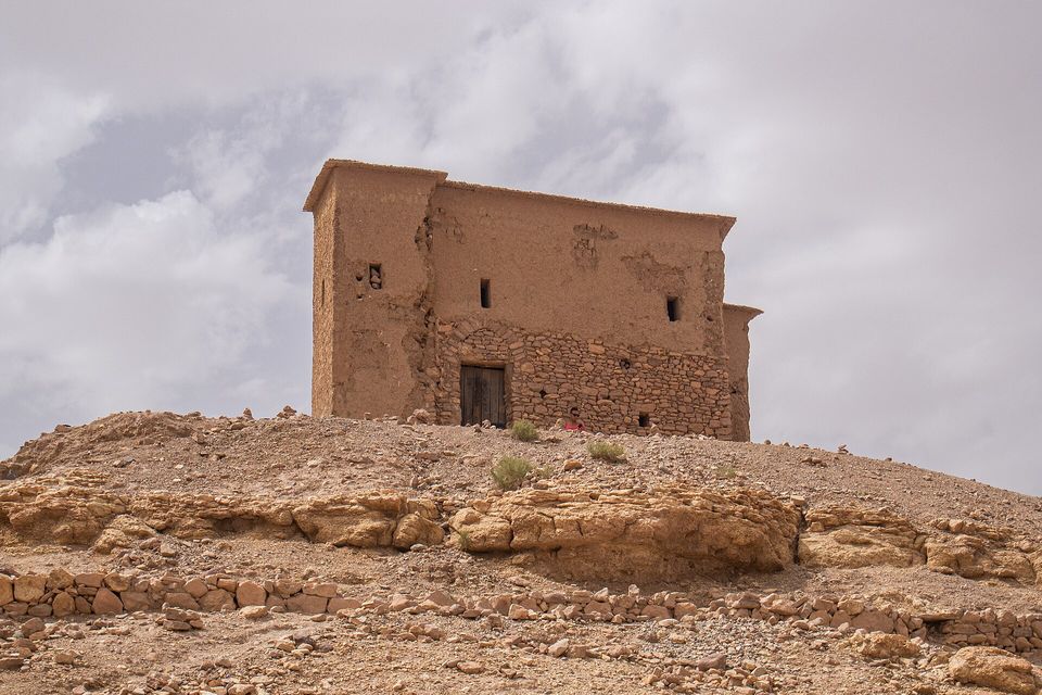
A stone-and-earth building on rocky ground at Aït Benhaddou, July 2019.
Photograph: C messier · CC BY-SA 4.0 · cropped
- People live behind some of these doors. Open none of them, and photograph nobody without asking.
- Climb to the top in the late afternoon, when the walls turn from brown to gold, and come down slowly.
- Walk round by the riverbed and look back. That is the view everyone else has been showing you.
- Drink your tea somewhere run by a family from here, and take your time over it.
- Find the way in without being turned round by the gate. (Turned round anyway, and very neatly. The gate has been added to the list as an item in itself.)
The baffle gate. The defensive walls of the ksar of Aït Benhaddou, reinforced with corner towers, are pierced with a baffle gate: an entrance built so that nobody can walk straight in, but must turn inside it before reaching the lanes. It is a defensive design, meant to slow anyone forcing an entry. It is made, like everything else here, of earth, and like everything else here it stands because someone keeps mending it.
Tally, in the marginA door built so that nobody can walk straight in. I walked in feeling rather clever, and the gate was kind enough to let me go on thinking so until I was well inside.
Getting there
How to get there. Aït Benhaddou is about 25 kilometres north-west of Ouarzazate in a straight line, by our measurement, and a short drive by road; Ouarzazate has an airport. From Marrakesh the road crosses the High Atlas by the Tizi n’Tichka pass. The ksar is reached on foot from the modern village, across the river by the footbridge.
Access. At the time of writing, post-earthquake restoration was continuing and some buildings may be closed or under repair. Check locally which buildings are open, and whether any charge to enter.
When to go. Wikipedia describes nearby Ouarzazate as hot and dry in summer and very cold in winter, and says snow can fall on the Tizi n’Tichka pass from November to March, so spring and autumn are the easier seasons. Late afternoon light suits the walls.
How to be there. People still live in the ksar and in the village below. Ask before photographing anyone, and do not open doors or climb walls.
Safety. The United States has Morocco at Level 2, exercise increased caution, because of terrorism, with no area-specific warnings. The advisory names tourist locations among possible targets and asks visitors to stay alert in tourist spots and avoid demonstrations.
Mark this place
Common questions
What is Ait Benhaddou?
Aït Benhaddou is a fortified village, or ksar, of earthen buildings on a hillside above the Ounila River in Ouarzazate province, southern Morocco. UNESCO, which has listed it as a World Heritage Site since 1987, calls it a striking example of the architecture of southern Morocco: houses crowded inside high walls with corner towers and a baffle gate.
What is Ait Benhaddou made of?
The buildings of Aït Benhaddou, in southern Morocco, are made entirely of rammed earth, adobe, clay brick and wood, according to Wikipedia’s account; the taller ones are rammed earth to the first floor and lighter adobe above. The earth, mixed with straw, erodes in rain and needs constant maintenance, which is why the ksar depends on restoration.
Does anyone live in Ait Benhaddou?
A few families still live inside the old ksar of Aït Benhaddou in Morocco, by Wikipedia’s account; most local people have moved to the modern village across the Ounila River and live from farming and tourism. UNESCO reports that the abandonment of the ksar has left its earthen buildings very vulnerable to a lack of maintenance.
Which films were shot at Ait Benhaddou?
Many. Wikipedia’s list of films shot at Aït Benhaddou, in southern Morocco, includes Lawrence of Arabia (1962), The Man Who Would Be King (1975), The Mummy (1999), Gladiator (2000) and Kingdom of Heaven (2005), and parts of the television series Game of Thrones were filmed there.
Was Ait Benhaddou damaged in the 2023 earthquake?
Slightly, compared with other sites. UNESCO’s 2024 state-of-conservation report on Aït Benhaddou records that the earthquake of 8 September 2023 damaged seven buildings to varying degrees, including the Ait Ougram and N’Oumghar kasbahs, brought down a collective granary and three of its five towers, and caused rockfalls in the south-west of the property. A house-restoration programme begun in 2014 was to resume and include some of them.
How old is Ait Benhaddou?
The site of Aït Benhaddou in Morocco has been fortified since the 11th century, by Wikipedia’s account, but UNESCO says none of the present buildings appears to be earlier than the 17th century. UNESCO adds that their structure and building technique were handed down in the valleys of southern Morocco from a very early period.
How far is Ait Benhaddou from Ouarzazate?
Aït Benhaddou is about 25 kilometres north-west of Ouarzazate in a straight line, a short drive by road. From Marrakesh the road crosses the High Atlas by the Tizi n’Tichka pass. The old ksar is reached on foot across the river from the modern village.
What is a ksar?
A ksar (plural ksour) is a fortified village of the pre-Saharan regions of North Africa, with houses and communal buildings crowded inside a defensive wall. Aït Benhaddou is, in UNESCO’s words, the most famous ksar in Morocco’s Ounila valley; UNESCO describes it as a group of earthen buildings surrounded by high walls, reinforced with corner towers and entered through a baffle gate.