
- Where
- Maranhão, north-eastern Brazil,
on the Atlantic coast - Coordinates
- 2.5333° S
43.1167° W - Area
- About 155,000 ha; about 90,000 ha
of dunes and lagoons (ICMBio) - Rain
- About 1,200 mm a year,
mostly January to May - Dunes moving
- 4 to 25 m a year
(UNESCO) - Status
- National park, 1981;
UNESCO World Heritage, 2024 - Fullest lagoons
- About May to September
Walked a long way over white sand that looked like an unmade bed, then came over a crest and there was a pool, clear and blue-green and warm as a bath, with small fish in it. In the middle of the dunes. Nobody could tell me where the fish go when the water leaves. I swam anyway, then in the next pool, and the next. The sand kept its secret.
The short answer
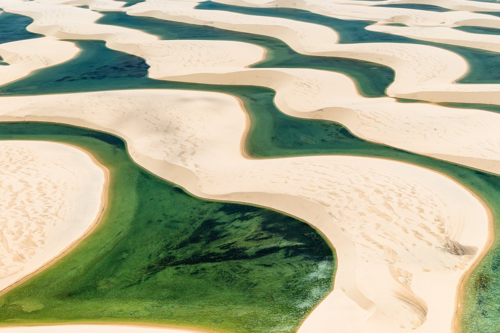
Lençóis Maranhenses National Park is a protected area on the Atlantic coast of Maranhão state in north-eastern Brazil, created in 1981 and run by the federal conservation agency ICMBio. The agency gives its area as 155,000 hectares, of which about 90,000 are free-moving dunes and the lagoons between them; the park spans the municipalities of Barreirinhas, Santo Amaro and Primeira Cruz. Lençóis is Portuguese for bedsheets, which the white dunes resemble from above. UNESCO inscribed the park as a World Heritage Site in 2024 for its natural beauty, describing a semi-humid climate in which the rainy season brings large volumes of water and forms temporary lagoons between the dunes.
It is not a desert. Wikipedia gives the rainfall as about 1,200 millimetres a year, about 70 per cent of it between January and May, against the usual definition of a desert as a place with less than 250 millimetres.
Why it's worth knowing
Most lakes stay where they are. These come back every year somewhere else.
The wind off the sea drives the dunes inland. UNESCO’s description of the site gives their migration as between 4 and 25 metres a year, and notes that because of it the lagoons that vanish in the dry season reappear the next rainy season in new locations, with altered shapes. No map of the lagoons stays true for long: the lakes are new each year, and the hollows that hold them have moved on.
Why the water stays at all is described in two ways. Wikipedia’s article says the lagoons are kept from draining by a layer of impermeable rock beneath the sand. ICMBio describes them as fed by the rain and by the rise and fall of the water table. The physicists Marco Luna, Eric Parteli and Hans Herrmann, who modelled the dune field, start from the second picture: the water table oscillates with the seasons, rising above the ground between the dunes in the wet season and sinking below it in the dry, and in their model that cycle is what shapes the long chains of dunes with ponds between them.
The field notes
Fish in the dunes
The lagoons are not empty. Wikipedia’s account says they are often connected with each other and with the rivers that cross the park, and that they hold fish and insects, among them the wolf fish, which burrows into wet mud and lies dormant through the dry season. The water is warm, between about 27.5 and 32 °C by the same account, slightly acid and low in nutrients, and it evaporates fast once the rains stop, losing up to a metre of depth a month.
Where the sand comes from
By Wikipedia’s account the sand is carried to the coast from the interior by the Parnaíba and Preguiças rivers, then driven back inland by the wind as far as 50 kilometres, in dunes up to about 40 metres high. The park is also home to four species on Brazil’s list of endangered species: the scarlet ibis, the neotropical otter, the oncilla and the West Indian manatee.
The rules of the sand
The dune field is protected ground. ICMBio’s visitor guidance says that motor vehicles may not drive over the open dunes, that visitors may not be taken in on private vehicles, that alcohol, fires and stoves are banned in the park, and that visitors should use the drivers, vehicles and guides the agency has accredited, who carry its badge. The park is open all year.
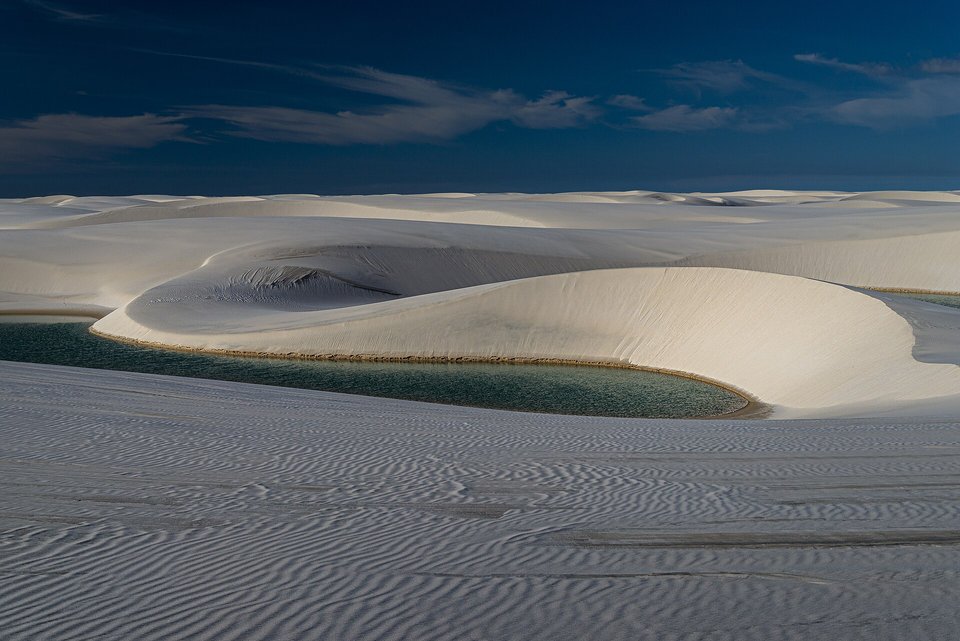
A rainwater lagoon in a hollow between the dunes, July 2017.
Photograph: Paulo Cattelan · CC BY-SA 4.0
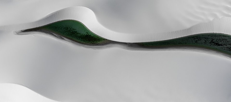
A single lagoon filling the slack between two dune ridges, seen from a light aircraft, August 2013.
Photograph: Dlaurini · CC BY-SA 4.0
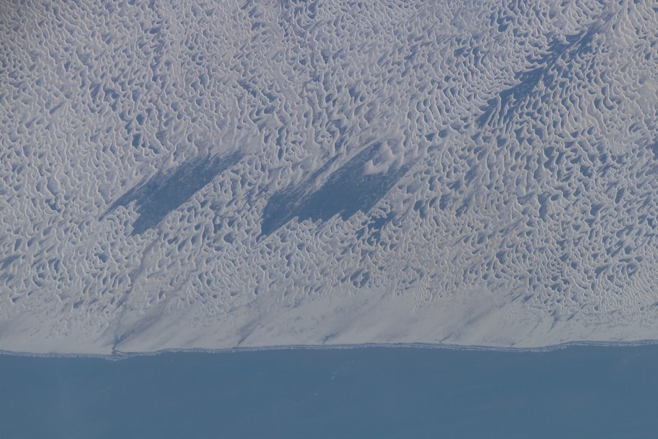
The dune field meeting the Atlantic coast, seen from the International Space Station, 21 September 2003 (astronaut photograph).
Astronaut photograph: NASA (ISS crew photograph ISS007-E-15177) via NASA Image and Video Library · Public domain · cropped
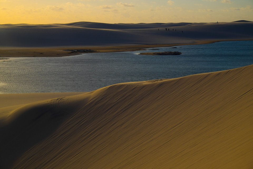
Evening light on the dunes and a lagoon at Lagoa Bonita, May 2015.
Photograph: Jardelsliumba · Lençóis de Areia · CC BY-SA 3.0
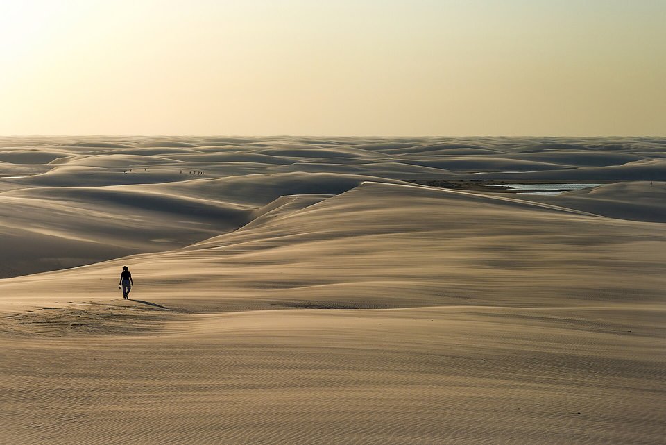
A walker on the dunes in hazy evening light, August 2015.
Photograph: Joao Lara Mesquita · CC BY-SA 4.0
- Come when the rains have filled the pools, not when it suits the calendar.
- Go with a guide the park has approved, and leave the open sand to the wind.
- Swim gently. These pools are somebody’s whole year.
- Stay on a crest for the sunset, then walk down before the light goes.
- Swim in every pool. (Swam in several. The rest will have moved by next year, so the list has agreed to move with them.)
A handful of white dune sand. Rivers carry it down to the coast from the interior, and the wind off the sea drives it back inland, as far as 50 kilometres, in dunes up to about 40 metres high. The dunes move between 4 and 25 metres a year, so the hollows between them move too, and the lagoons that fill them each rainy season come back in different places and different shapes. Every photograph of the lagoons is of an address that no longer quite exists.
Tally, in the marginSo it is the sand in my shoes that moves the lakes about. I had made a careful note of exactly where my pool was, which I now understand was a very sweet and entirely useless thing to do.
Getting there
How to get there. Fly to São Luís, the capital of Maranhão; Brazil’s Ministry of Tourism names São Luís and Parnaíba as the nearest airports. Barreirinhas, the main gateway, is about 260 kilometres from São Luís, about four hours by road on the BR-135 and MA-402, by bus, van or transfer. Santo Amaro, the other main gateway, is at the end of 46 kilometres of sand track passable only by four-wheel-drive vehicles fitted with snorkels.
When to go. The rains fall mainly from February to May, by ICMBio’s account, and the lagoons are fullest from about May to September; the Ministry of Tourism says the high-water season runs to September. Later in the dry season many lagoons shrink or vanish.
What to book ahead. A trip with an ICMBio-accredited operator from Barreirinhas or Santo Amaro, since private vehicles may not carry visitors into the park. Popular circuits from Barreirinhas include the Lagoa Azul and Lagoa Bonita routes. Longer guided treks cross the dunes over several days.
Safety. The United States has Brazil at Level 2, exercise increased caution, because of crime and kidnapping. Its Level 4 areas are within 160 kilometres of the land borders with Bolivia, Colombia, Guyana, French Guiana, Paraguay, Peru, Suriname and Venezuela, informal settlements such as favelas, and some of Brasília’s satellite cities at night; by this entry’s measurement the park is about 1,200 kilometres from the nearest of those borders. The advisory warns against walking on beaches after dark, accepting drinks from strangers and displaying wealth, and calls for extra caution on public buses, especially at night, and when hiking in isolated areas. Carry water and sun protection: there is no shade on the dunes.
Mark this place
Common questions
Where is Lençóis Maranhenses?
Lençóis Maranhenses National Park is on the Atlantic coast of Maranhão state in north-eastern Brazil, in the municipalities of Barreirinhas, Santo Amaro and Primeira Cruz. Its main gateway, Barreirinhas, is about 260 kilometres by road from São Luís, the state capital, according to Brazil’s Ministry of Tourism.
Is Lençóis Maranhenses a desert?
No. Lençóis Maranhenses in Brazil looks like a desert of white dunes, but Wikipedia gives its rainfall as about 1,200 millimetres a year, far above the 250 millimetres that usually defines a desert, and UNESCO describes its climate as semi-humid. The rain is what fills the lagoons between the dunes.
Why do lagoons form between the dunes of Lençóis Maranhenses?
The lagoons of Lençóis Maranhenses fill in the rainy season, mainly February to May. Brazil’s conservation agency ICMBio describes them as fed by the rain and by the seasonal rise of the water table; Wikipedia’s account adds a layer of impermeable rock beneath the sand. In the dry season they evaporate, losing up to a metre of depth a month.
Do the lagoons of Lençóis Maranhenses move?
In effect, yes. UNESCO notes that the dunes of Lençóis Maranhenses migrate between 4 and 25 metres a year, so the lagoons that dry out each dry season reappear the next rainy season in new locations and with altered shapes. The lagoons of one year are not quite the lagoons of the next.
When is the best time to visit Lençóis Maranhenses?
The lagoons of Lençóis Maranhenses in Brazil are fullest from about May to September, after the rains of February to May; ICMBio gives May to September as the best period to visit, and Brazil’s Ministry of Tourism says the high-water season runs until September. Later in the dry season many lagoons shrink or disappear.
Are there fish in the lagoons of Lençóis Maranhenses?
Yes. Wikipedia’s account says the lagoons of Lençóis Maranhenses are often linked with each other and with the park’s rivers, and hold fish and insects, including the wolf fish, which burrows into wet mud and lies dormant through the dry season until the rains return.
How do you visit Lençóis Maranhenses National Park?
Visitors reach Lençóis Maranhenses National Park from Barreirinhas or Santo Amaro do Maranhão with drivers and guides accredited by ICMBio, Brazil’s federal conservation agency. Private vehicles may not carry visitors in, motor vehicles may not drive on the open dunes, and alcohol, fires and stoves are banned inside the park.
Is Lençóis Maranhenses safe to visit?
The United States has Brazil at Level 2, exercise increased caution, because of crime and kidnapping. Its do-not-travel zone along Brazil’s land borders lies far from Lençóis Maranhenses, which is on the north-east coast about 1,200 kilometres from the nearest listed border by this entry’s measurement. The advisory warns against walking on beaches after dark and accepting drinks from strangers.