
- Where
- Daniel Campos Province, Potosí Department
southwestern Bolivia - Coordinates
- 20.1338° S
67.4891° W - Biome
- High-altitude salt flat
on the Altiplano - Size
- About 10,582 km²
at 3,656 m above sea level - Relief
- Less than 1 m of vertical relief
over about 9,000 km² (Borsa and others, 2008) - Origin
- The dried remains of prehistoric lakes
Minchin, Tauca and Coipasa - Best visited
- January for the mirror (with luck),
November for the flamingos
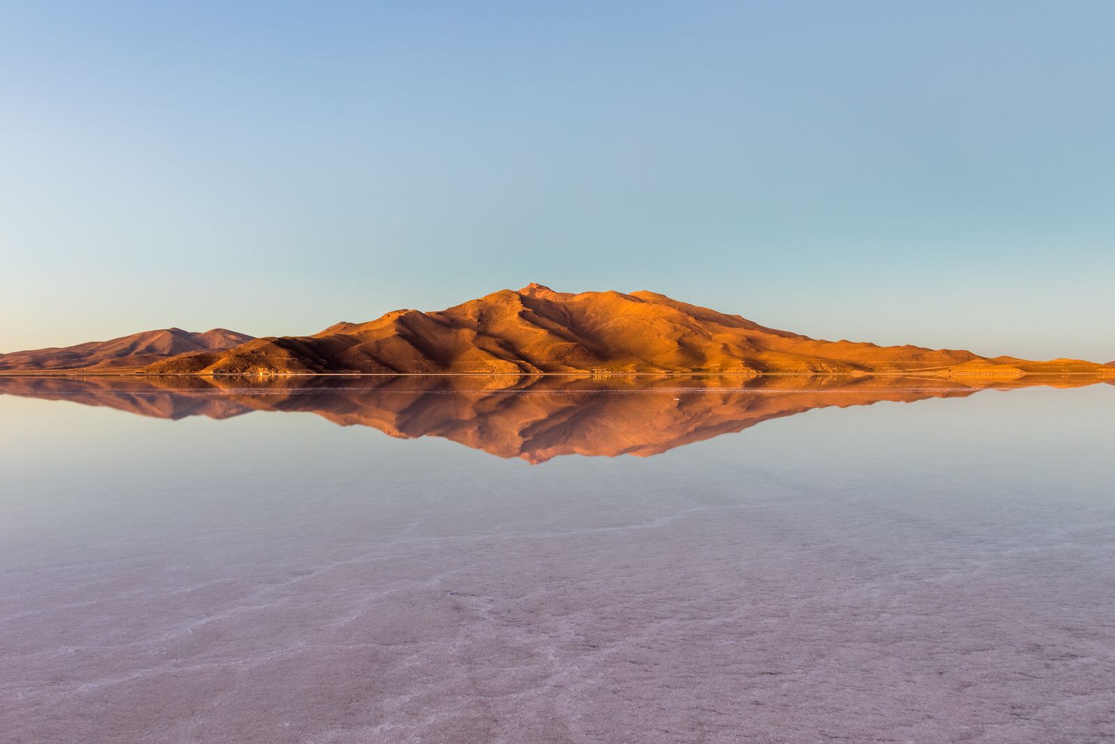
Drove for hours across white ground so flat it met the sky with no horizon, until a skin of rain lay over it and the ground became a mirror. I stood on a cloud and could not tell which way up I was. Out in the glare, a hill of giant cacti sat like a ship at anchor. The air was thin, and so quiet I could hear my heartbeat.
The short answer
Salar de Uyuni is the largest salt flat in the world, about 10,582 square kilometres in Daniel Campos Province, Potosí Department, in the Altiplano of southwestern Bolivia, at 3,656 metres above sea level. It is the dried remains of a succession of prehistoric lakes, covered by a salt crust that lies over a pool of brine rich in lithium. Its surface has less than a metre of vertical relief over thousands of square kilometres, which is why space agencies have used it to calibrate satellite instruments. After rain, a thin layer of still water can turn it into what Wikipedia calls the world’s largest mirror. Uyuni is also the name of the town that serves as its gateway, and for many local people the flat belongs to the mountain Tunupa.
Why it's worth knowing
The postcard is of the mirror: a person standing on the sky. The story underneath is stranger, and it is about how flat “flat” can be.
In September 2002 Adrian Borsa and colleagues drove a kinematic GPS survey across a block of the eastern salar 45 by 54 kilometres, to give NASA’s ICESat laser altimeter a surface to be checked against. Their paper in the Geophysical Journal International (2008) describes the salar as having less than a metre of vertical relief over about 9,000 square kilometres, and found a range of only 80 centimetres across the surveyed block. Against that model, H. A. Fricker and colleagues reported in 2005 that under the best conditions ICESat’s elevations over the salar were accurate to within 2 centimetres. A second 2008 paper, by Borsa, Bills and Minster, modelled the surface as an equipotential of Earth’s gravity field: in effect, as level as the planet’s gravity defines level. Radar missions have used it too; the European Space Agency’s Sentinel-3B did calibration work there in February 2024.
Then look at what is underneath. The crust lies over brine that contains lithium at about 0.3 per cent. Wikipedia, citing a 2024 estimate, gives Bolivia about 22 per cent of the world’s known lithium resources, most of them in this salar. NASA astronauts photographed a lithium extraction facility on the flat in February and July 2026. The surface that the mirror photographs made famous is also an industrial site, and an argument.
And it is somebody’s. In the Aymara story told about it, the mountains Tunupa, Kusku and Kusina were giants; Tunupa married Kusku, who ran away with Kusina, and Tunupa’s tears mixed with her milk to make the salar. Many local people regard Tunupa as an important deity and say the flat should be called Salar de Tunupa.
The field notes
A chain of vanished lakes
The Altiplano is a high plateau formed as the Andes rose, and it drains inwards. According to the reconstruction Wikipedia gives, the area was once part of a giant prehistoric lake, Lake Minchin, 30,000 to 42,000 years ago; it became Paleo Lake Tauca, at a maximum depth of about 140 metres, and then Lake Coipasa, dated to 11,500 to 13,400 years ago. Estimates of Tauca’s age run from 13,000–18,000 to 14,900–26,100 years, depending on the study. When Coipasa dried it left two lakes, Poopó and Uru Uru, and two salt flats, Salar de Coipasa and the larger Salar de Uyuni, roughly 100 times the size of the Bonneville Salt Flats in the United States.
Islands stand in the middle of the salar: the tops of ancient volcanoes that were submerged in the era of Lake Minchin. They carry fragile coral-like structures and deposits of fossils and algae, and the best known, Incahuasi, hosts colonies of viscachas. Giant cacti dominate the sparse vegetation; they grow at about a centimetre a year and reach up to 12 metres.
A mirror on demand
Rain is scarce: 1 to 3 millimetres a month between April and November, rising to as much as 80 millimetres in January, and outside January even the rainy season has fewer than five rainy days a month. The mirror needs a thin layer of water on the flat and still air, so it is a wet-season event, most likely in and around January, and neither is guaranteed. In the dry season the flat is white salt crust.
The average temperature peaks at about 21°C from November to January and is lowest, about 13°C, in June, but the nights are cold all year, between −9 and 5°C. Relative humidity stays between 30 and 45 per cent.
Salt hotels, a railway, and a co-operative
The first salt hotel, the Palacio de Sal, was built in the middle of the flat in 1993–95 out of blocks cut from the salar, and dismantled in 2002 after sanitation problems and pollution. A new hotel of the same name opened around 2007 at the eastern edge, 25 kilometres from the town of Uyuni.
The town’s train cemetery lies 3 kilometres outside it. The railway to the Pacific ports was built by British engineers between 1888 and 1892 for the Antofagasta and Bolivia Railway Company, encouraged by President Aniceto Arce, and was interrupted by local Aymara people who saw it as an intrusion. The mining trade collapsed in the 1940s and many trains were left where they stood.
Salt is still harvested by a co-operative: Wikipedia records that all the miners working the salar belong to the Colchani co-operative, and that less than 25,000 tonnes a year are extracted from an estimated 10 billion tonnes of salt.
Birds, and a good deal of nothing
The salar itself is close to devoid of wildlife and vegetation. Every November it becomes a breeding ground for three species of South American flamingo, the Chilean, the Andean and the rare James’s, which feed on brine shrimp. About 80 other bird species have been recorded, and the island colonies include viscachas, rabbit-like rodents. Wikipedia’s account of the flora names giant cacti of the genus Echinopsis, along with quinoa plants and queñua bushes.
The flat is also a road: a major transport route across the Altiplano, except when seasonally under water. Wikipedia counts 16 reported accidents on the salar, with more than 30 deaths in total, blaming poorly maintained vehicles, untrained drivers, speeding and a lack of regulation of tour companies. It is worth choosing an operator on that basis.
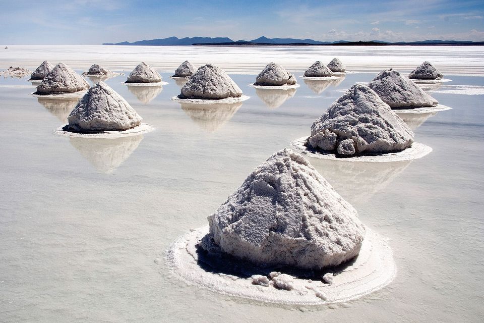
Salt piled into cones to dry on the flat.
Photograph: Luca Galuzzi - www.galuzzi.it (edit by Trialsanderrors) · Piles of Salt Salar de Uyuni Bolivia Luca Galuzzi 2006 a · CC BY-SA 2.5 · cropped
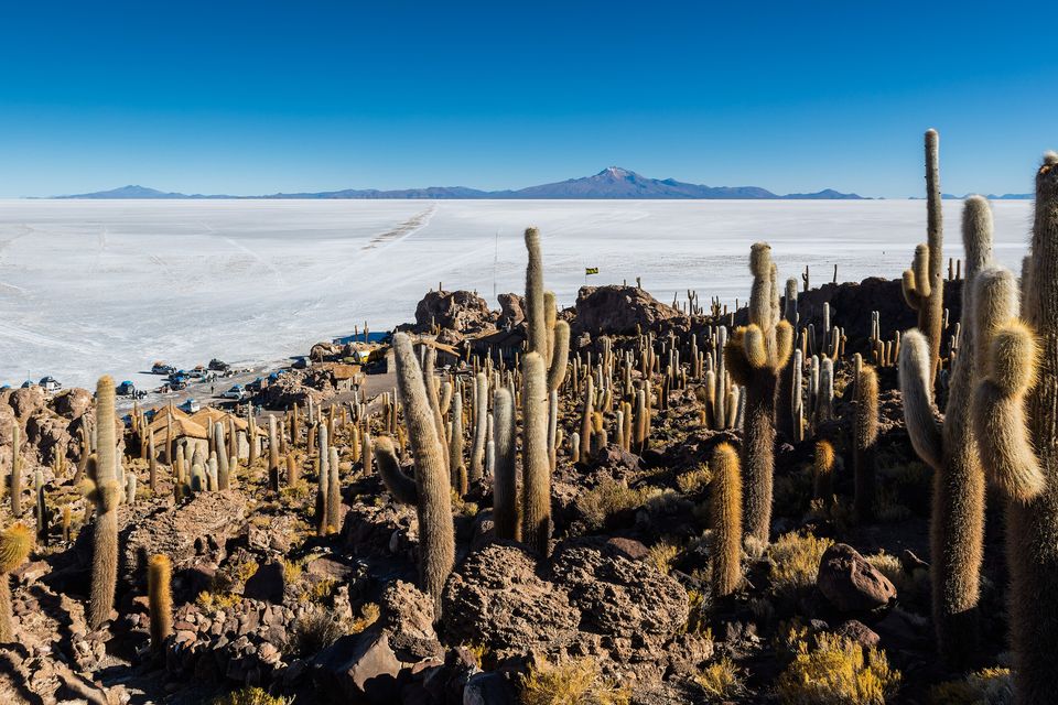
Giant cacti on Incahuasi Island, the top of an old volcano standing in the salt.
Photograph: Diego Delso · CC BY-SA 4.0 · cropped
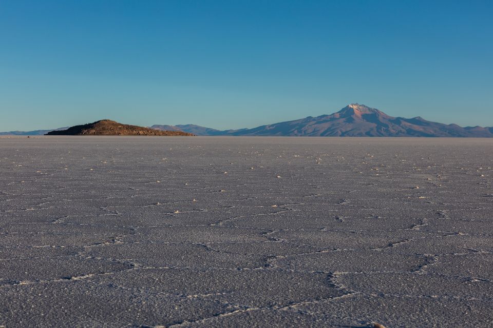
The dry crust in February: salt in polygons, not a mirror.
Photograph: Diego Delso · CC BY-SA 4.0
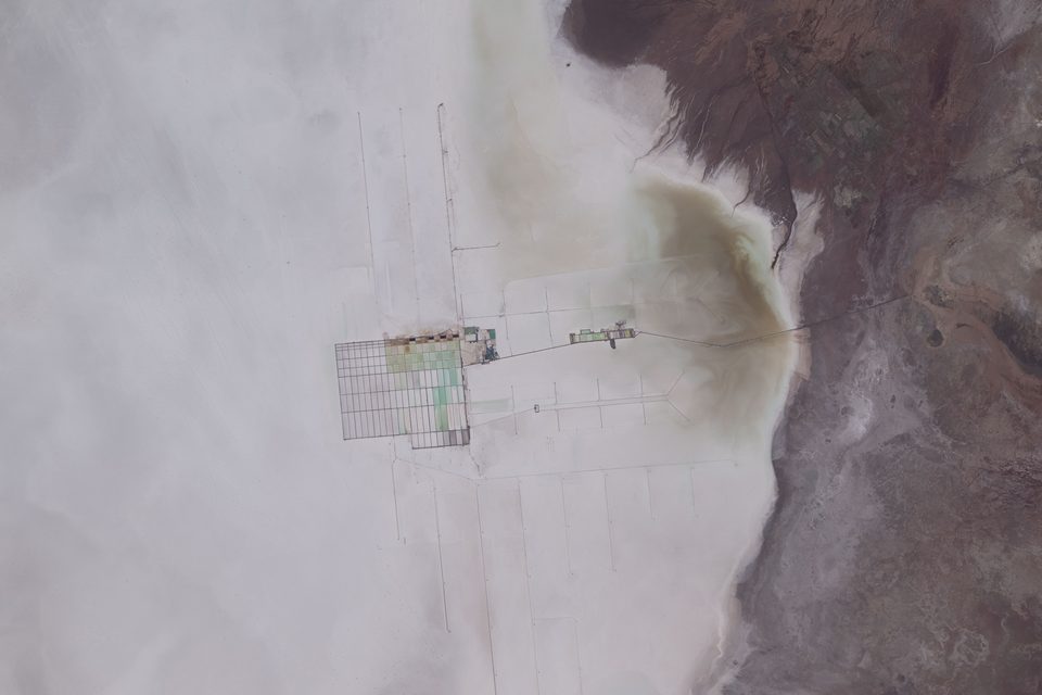
A lithium extraction plant on the salar, photographed from the International Space Station on 21 February 2026 (astronaut photograph).
Astronaut photograph: NASA/Jessica Meir · Public domain
- Take a jacket for the nights and sunglasses for the days. Both are meant seriously.
- Go when there is a little water on it, and then stand very still. (Item retained, for the next rain.)
- Walk up the island of giant cacti slowly. They are in no hurry, and neither should you be.
- Choose your driver more carefully than your hotel.
- Ask whose mountain that is on the horizon, and how they say its name.
A table made of salt. At the salt hotels on the flat, the walls, the roof and the furniture are built of blocks cut from the salar itself. The first, the Palacio de Sal, was built out in the middle of the flat in the mid-1990s and dismantled in 2002 after sanitation problems and pollution; a new hotel of the same name opened around 2007 at the eastern edge, some 25 kilometres from the town of Uyuni. Whether you see one depends on the tour you choose, so ask the operator.
Tally, in the marginI had set my cup down on it before I noticed what it was made of, and then could not decide whether to apologise to the table or to the floor.
Getting there
How to get there. The town of Uyuni is the gateway. It is reached by road from other Bolivian cities and by air from La Paz; the road journeys are long, and demonstrations in Bolivia can block transport with little warning, so leave slack in the schedule. From Uyuni, tours run from a day to several days, and some continue over the border into Chile.
When to go. For the mirror, the wet season, in and around January, and only if it has rained recently and the wind is down; the nights are cold all year. For flamingos, November. For the dry white crust and the easiest driving, the months between April and November. Ask the operator honestly what the surface is like the week you go.
What to book ahead. A tour is the way most people see the flat: it is a vast, unsigned expanse and vehicles need drivers who know the routes. Pick the operator with care, given the accident record above, and ask about vehicle maintenance, driver hours and spare fuel. Book lodging in the town of Uyuni or a salt hotel ahead in the high season.
Altitude and safety. The salar is at 3,656 metres, so sun protection, water and slow movement matter, and the State Department’s advisory asks travellers to consider the risk of high altitude and notes that medical services in rural areas are limited. Bolivia is at Level 2 for crime and civil unrest; the only Level 4 area is Chapare Province, in another part of the country, far from Uyuni.
Mark this place
Common questions
How big is the Salar de Uyuni?
The Salar de Uyuni covers about 10,582 square kilometres at 3,656 metres above sea level in Potosí Department, Bolivia, and is the largest salt flat in the world. NASA’s caption for a 2005 astronaut photograph gives roughly 8,000 square kilometres; the larger figure is the one this entry uses. The salt is covered by a crust from tens of centimetres to a few metres thick, over brine.
Why do satellites use the Salar de Uyuni?
Because the Salar de Uyuni is exceptionally level and bright. A kinematic GPS survey by Adrian Borsa and colleagues in September 2002, published in 2008, describes less than a metre of vertical relief over about 9,000 square kilometres and an 80-centimetre range across a 45-by-54-kilometre block. Checked against that surface, NASA’s ICESat laser altimeter proved accurate to within 2 centimetres under the best conditions (Fricker and others, 2005).
When is the Salar de Uyuni a mirror?
After rain, when a thin layer of still water covers the salt. Rainfall on the Salar de Uyuni is 1 to 3 millimetres a month between April and November and up to 80 millimetres in January, so the mirror is a wet-season effect, most likely around January, and needs calm air. It is not guaranteed: in the dry season the flat is bare white crust.
How did the Salar de Uyuni form?
From the drying of prehistoric lakes on the Bolivian Altiplano: Lake Minchin, then Paleo Lake Tauca (up to about 140 metres deep), then Lake Coipasa, dated to 11,500 to 13,400 years ago. When Coipasa dried it left Lake Poopó and Lake Uru Uru and two salt flats, Coipasa and Uyuni. Dating varies between studies; Tauca’s age ranges from 13,000 to 26,100 years across estimates.
Is there lithium in the Salar de Uyuni?
Yes. The brine beneath the salt crust holds lithium at about 0.3 per cent, and Wikipedia, citing a 2024 estimate, puts about 22 per cent of the world’s known lithium resources in Bolivia, most of them in this salar. NASA astronaut photographs from February and July 2026 show a lithium extraction facility on the flat. Extraction by foreign companies in the 1980s and 1990s met strong opposition from local communities, who did not expect the money to reach them.
What does Uyuni mean, and who is Tunupa?
Uyuni comes from the Aymara language and means a pen or enclosure; it is also the name of the gateway town. Tunupa is a mountain and, in an Aymara story, a giant whose tears and milk formed the salar after her husband Kusku left her for Kusina. Many local people regard Tunupa as a deity and say the flat should be called Salar de Tunupa.
What is the Uyuni train cemetery?
A field of abandoned steam locomotives and carriages 3 kilometres outside the town of Uyuni, connected to it by the old tracks. The railway to the Pacific ports was built by British engineers between 1888 and 1892 for the Antofagasta and Bolivia Railway Company. The mining trade collapsed in the 1940s and many trains were left where they stood.
Is it safe to visit the Salar de Uyuni?
Mostly, with care. The State Department has Bolivia at Level 2 for crime and civil unrest, reissued 28 April 2026, and only Chapare Province at Level 4. The salar lies in Potosí Department, far from Chapare. The risks to plan for are high altitude, limited rural medical services, demonstrations that block roads, and tour-vehicle accidents: Wikipedia counts 16 reported accidents with more than 30 deaths.