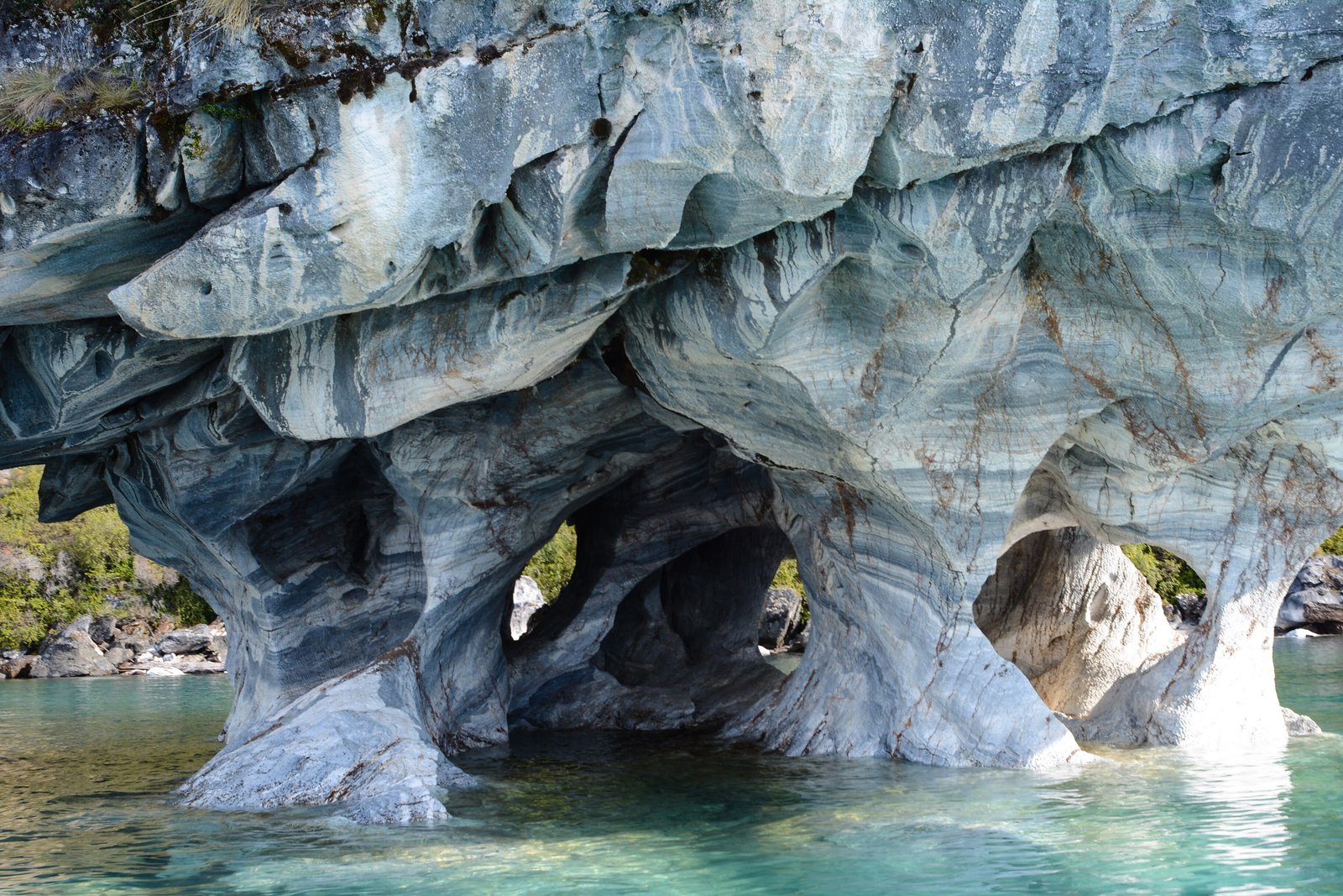

Part of Patagonia
- Where
- Western shore of General Carrera Lake
Aysén Region, Chile - Coordinates
- 46.658° S
72.625° W - Rock
- Marble about 300 million years old
(Chile Travel) - Protected
- Nature Sanctuary
since 1994 - Visitors
- About 30,000 a year
(National Monuments Council) - The lake
- 1,850 km²; called Lago Buenos Aires
on the Argentine side - Advisory
- Chile Level 2
Came down a gravel road with the wind trying to take the car, to a milky turquoise lake under snowy mountains. A little boat took us across the chop and in under pale stone, striped grey and white and faintly blue, hollowed into rooms. Light off the water moved over the ceilings like breathing. I needed one hand for my hat and wished for another to point with.
The short answer
The Marble Caves, in Spanish the Capillas de Mármol, are a set of marble outcrops on the western shore of General Carrera Lake, south of the village of Puerto Río Tranquilo in Chile’s Aysén region. Chile’s National Monuments Council describes marble outcrops along about 300 metres of shore, and records the names local people and boat operators use: the Cathedral for the most prominent islet, the Chapels for the two small ones beside it, and the Caverns for the larger Panichini islands. They have been a Nature Sanctuary since 1994, and the council records about 30,000 visits a year. There is no path to them. They are seen from the water, by boat or kayak.
Why it's worth knowing
Sea caves need waves, and waves need a large stretch of water and wind. General Carrera Lake has both. Its area is about 1,850 square kilometres, and Wikipedia’s account makes it the largest lake in Chile and gives its western basin a depth of 586 metres; its older name, Chelenko, is given in the same account as meaning “stormy waters”. On its western shore the lake has worked at a band of marble the way the sea works at a cliff.
The Museo Regional de Aysén, which runs the Chelenko Geopark project around the lake, describes the formations as karstic, cut by the lake’s water eroding the rock of the shore cliffs into caves. Wikipedia’s article on the lake puts the carving at the last 6,200 years; this entry found no Chilean geological survey figure for it. The rock is far older. Chile’s official tourism site, Chile Travel, dates the marble to the upper Palaeozoic, about 300 million years ago, and the council records it as about 94 per cent calcium carbonate.
The blue is borrowed. Chile Travel explains the colour as the lake’s: glacial meltwater carries fine sediment that turns the water turquoise, and the tones on the walls change with the position of the sun, the time of day, the level of the lake and the amount of sediment in it. The marble has colours of its own: the council describes several tones in the stone, with white predominating.
The field notes
One lake, two names
General Carrera Lake crosses the border. By Wikipedia’s account 970 square kilometres of it are Chilean and 880 Argentine, and the two countries call it by different names: General Carrera on the Chilean side, where it was officially renamed in 1959, and Lago Buenos Aires on the Argentine side. It drains west to the Pacific through the Baker River; during the last glaciation, the same account says, it drained east to the Atlantic.
Where exactly is the sanctuary?
The 1994 decree has been questioned on its own map. In 2022 the Chilean outlet El Desconcierto examined it and reported that its text points to a group of islands called Panichini, in front of the caverns that are actually visited, that its 50 hectares match no sector of the area, and that it places the caves in the commune of Río Ibáñez although they lie in Chile Chico. This entry could not consult the decree itself.
A rule about the water
In January 2026 a video of visitors swimming beside the formations drew complaints. Chile’s navy, the maritime authority on the lake, said that swimming in General Carrera Lake is not prohibited, and fined the swimmers instead for not wearing life jackets, which are compulsory for activities on the water, as the Chilean broadcaster 24 Horas reported.
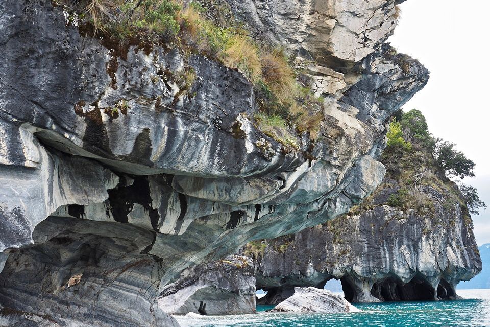
Marble cliffs on General Carrera Lake, undercut into arches at the waterline, October 2017.
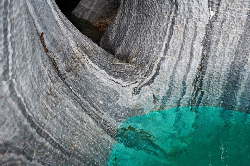
Close in: rippled, banded marble meeting turquoise water, October 2017.
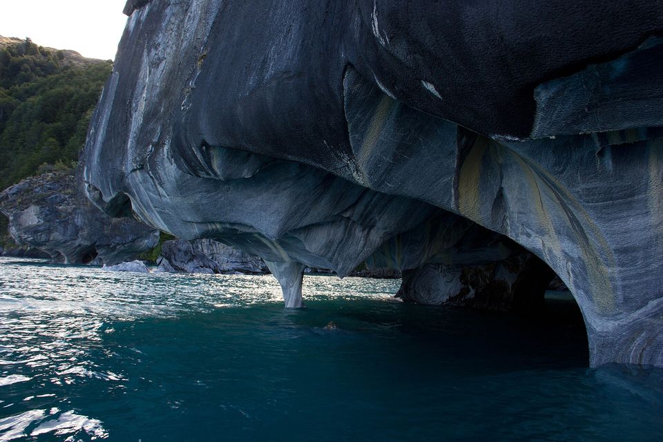
An overhang of polished marble at the Cathedral, seen from the water, February 2012.
Photograph: Gabriel Urrutia Galaz · Catedral de Marmol - Patagonia · CC BY-SA 2.0
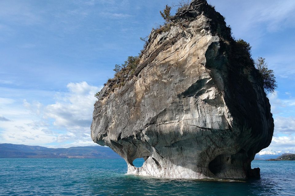
The Chapel, a free-standing marble islet, with snow on the far mountains, November 2017.
Photograph: Sissssou · CC BY-SA 4.0 · cropped
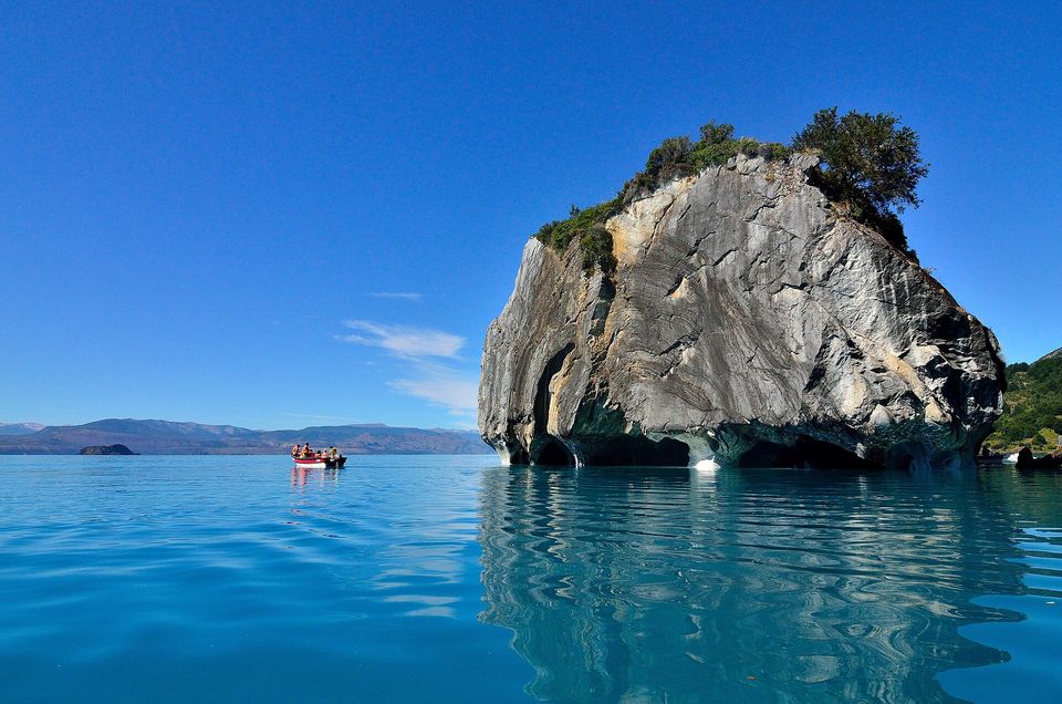
The Cathedral island from the lake, reflected in calm water, January 2013.
Photograph: javier (jvieras) · Marble cathedral · CC BY 2.0
- Go out in the morning, before the wind gets up. The lake decides, not you.
- Wear the life jacket the boatman hands you, and keep it on.
- Keep your hands off the walls. They have taken a very long time to get like that.
- Look down as well as up. Some of the best colour is in the water under the boat.
- Describe the colour of the water in one word. (Tried several. None of them was it. There is a page at the back now for words that were nearly it.)
A wall of marble at the waterline. The stone of the formations is marble, about 300 million years old and about 94 per cent calcium carbonate, in several tones with white predominating. The lake’s water has smoothed and hollowed it into rooms and pillars where it meets the surface. Visitors come for the blue on the walls, which belongs to the water and its glacial silt; the paler colours underneath belong to the rock.
Tally, in the marginEveryone on the boat was photographing the blue, which it turns out is only on loan from the water. The white underneath belongs to the rock, which has not once asked for the credit.
Getting there
How to get there. Flights reach Balmaceda, the airport for Coyhaique, the regional capital. Chile Travel puts Puerto Río Tranquilo about 223 kilometres south of Coyhaique, four to five hours by road on the Carretera Austral. Boat and kayak trips to the formations leave from Puerto Río Tranquilo; Chile Travel gives the boat trip as about an hour and a half.
When to go. Chile Travel says the formations can be visited all year, with the busiest season from November to March, when the weather is steadier and the days longer. For going inside the caverns it recommends spring and autumn, when the lake is lower. Wind can close the lake to small boats on any day; build a spare day into the plan.
On the water. Life jackets are compulsory, and the navy fines people for not wearing them.
Safety. The State Department has Chile at Level 2, exercise increased caution, because of crime and civil unrest in Santiago and other cities, with no area-specific warnings; the advisory carries a Centers for Disease Control Level 1 notice for Andes virus (hantavirus) in the region and says the risk for most travellers is extremely low. Argentina, across the lake, is at Level 1.
Mark this place
Common questions
Where are the Marble Caves?
The Marble Caves, or Capillas de Mármol, are on the western shore of General Carrera Lake in the Aysén region of Chilean Patagonia, south of the village of Puerto Río Tranquilo on the Carretera Austral. They can only be seen from the water, by boat or kayak from Puerto Río Tranquilo.
How were the Marble Caves formed?
The Marble Caves were cut by the waves of General Carrera Lake eroding and dissolving marble cliffs on its shore, a process Chile’s Museo Regional de Aysén describes as karstic. Wikipedia puts the carving at the last 6,200 years; the marble itself formed about 300 million years ago, according to Chile Travel.
Why is the water at the Marble Caves so blue?
The blue at the Marble Caves comes from General Carrera Lake, not the rock. Chile Travel explains that glacial meltwater carries fine sediment that turns the lake turquoise, and that the colours on the marble walls change with the sun, the time of day, the lake’s level and the amount of sediment in the water. The marble itself is mostly white, by Chile’s National Monuments Council’s description.
How do you visit the Marble Caves?
Visitors reach the Marble Caves by boat or kayak from Puerto Río Tranquilo, on Chile’s Carretera Austral. Chile Travel puts Puerto Río Tranquilo about 223 km south of Coyhaique, four to five hours by road, with flights to nearby Balmaceda. Life jackets are compulsory on the lake.
When is the best time to visit the Marble Caves?
The Marble Caves in Chile can be visited all year. Chile Travel says the busiest season is November to March, when the weather is steadier and the days longer, and that spring and autumn are best for entering the caverns, because General Carrera Lake is lower then.
Are the Marble Caves protected?
Yes. The Capilla de Mármol has been a Nature Sanctuary since 1994, and Chile’s National Monuments Council lists it with about 30,000 visits a year. In 2022 the outlet El Desconcierto reported that the decree’s text and area do not match the formations actually visited.
Can you swim at the Marble Caves?
Chile’s navy said in January 2026, after a video of people swimming beside the Marble Caves, that swimming in General Carrera Lake is not prohibited. It fined the swimmers for not wearing life jackets, which are compulsory for activities on the lake.
Why does General Carrera Lake have two names?
General Carrera Lake is shared by Chile and Argentina, and each country names its part: General Carrera in Chile, where it was officially renamed in 1959, and Lago Buenos Aires in Argentina. At about 1,850 km² it is the largest lake in Chile; its older name, Chelenko, is still used, for example by the Chelenko Geopark project.