

- Where
- Southern Argentina & Chile
below roughly 39° S - Gateways
- El Calafate, Puerto Natales,
Puerto Madryn, Punta Arenas - Landscape
- Andes & ice field (west)
desert steppe & coast (east) - Getting around
- Ruta 40 (AR), Ruta 9 (CL),
domestic flights - Season
- November–March, mostly
- Advisory
- Argentina & Chile:
check current levels
Two Patagonias
The word covers roughly a million square kilometres across two countries, and the single most useful thing to understand before planning anything is that it contains two unrelated landscapes.
The west is the Andes and the Southern Patagonian Ice Field: glaciers, granite, lakes the colour of antifreeze, and weather that arrives off the Pacific with nothing to slow it down. This is Torres del Paine, Perito Moreno, El Chaltén. Wet, dramatic, and the reason most people come.
The east is desert. The Andes wring the moisture out of the westerlies, and what reaches the Atlantic side is a dry steppe of scrub and wind running to a coast of cliffs and gulfs. This is Península Valdés and Cueva de las Manos. Fewer photographs, more wildlife, and almost no crowds.
The distances between them are genuinely large. Puerto Madryn to El Calafate is around 1,600 kilometres. People routinely underestimate this and plan itineraries that cannot be driven.
A note on two Perito Morenos
Worth clearing up before it costs someone a day. Perito Moreno Glacier is in Los Glaciares National Park near El Calafate, in southern Santa Cruz. The town of Perito Moreno is roughly 350 kilometres north, and it is the gateway to Cueva de las Manos. There is also a Perito Moreno National Park, which is a third place again.
All are named for Francisco P. Moreno, the explorer and boundary expert. Booking accommodation in one while intending to visit another is a common and expensive mistake.
When to go, and the wind
November to March is the general answer — austral spring and summer, longest daylight, most services open. But the east coast runs on wildlife calendars instead: southern right whales at Península Valdés roughly June to December, orca stranding at Punta Norte usually cited for March and April.
The wind is not a detail. At these latitudes the westerlies circle the planet without meeting a landmass, and in the mountains they funnel and accelerate. Gusts over 100 kilometres per hour are ordinary. Weather can change faster than a forecast refreshes: five hikers died of exposure on an exposed pass in Torres del Paine in November 2025, a day after a trekker crossed the same ground under clear skies.
Places in this collection
-
 Entry № 013
Cueva de las Manos
Hundreds of hands stencilled on a canyon wall in blown pigment. More than nine in ten are left hands, and one has six fingers.
-
 Entry № 014
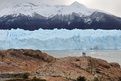
Perito Moreno Glacier
A glacier that has dammed an arm of the lake, held the water back for years, and then lost, and that is now retreating.
-
 Entry № 017
Torres del Paine
A granite laccolith built in ninety thousand years and sliced open by ice — and, contrary to many sources, not a World Heritage Site.
-
 Entry № 018
Península Valdés
Orcas that throw themselves onto the beach on purpose to hunt, using a technique the adults teach the young.
-
 Entry № 136
Ushuaia
Argentina's southernmost city calls itself the world's. Across the Beagle Channel, Chile's Puerto Williams lies about 15 km farther south and has counted as a city since 2019.
-
 Entry № 138
Marble Caves
On a Patagonian lake big enough to raise real waves, the water has hollowed a marble shore into chapels and tunnels, and glacial silt in the water turns the walls blue.
Common questions
Where exactly is Patagonia?
Patagonia is the southern portion of South America, spanning both Argentina and Chile below roughly 39 degrees south and covering around a million square kilometres. The Andes divide it: a wet mountain and ice-field zone on the Chilean and western Argentine side, and dry desert steppe running to the Atlantic on the east.
How long does it take to travel across Patagonia?
Longer than most itineraries assume. Puerto Madryn on the Atlantic coast to El Calafate near the ice field is roughly 1,600 kilometres, and distances between major sites are commonly several hundred kilometres of empty road. Domestic flights between Buenos Aires and regional airports are usually the practical answer rather than driving the whole way.
When is the best time to visit Patagonia?
November through March, the austral spring and summer, is the general window for the mountains and ice field, with the longest daylight and most services open. The Atlantic coast follows wildlife calendars instead: southern right whales at Península Valdés roughly June to December, and orca stranding at Punta Norte usually cited for March and April.
What is the difference between the Perito Moreno Glacier and the town of Perito Moreno?
They are separate places roughly 350 kilometres apart. The Perito Moreno Glacier is in Los Glaciares National Park near El Calafate in southern Santa Cruz Province; the town of Perito Moreno is in the north of the province and is the gateway to Cueva de las Manos. A Perito Moreno National Park exists as well. All are named for the explorer Francisco P. Moreno.
How bad is the wind in Patagonia?
Serious enough to plan around. At these latitudes the prevailing westerlies circle the globe without meeting a landmass, and gusts over 100 kilometres per hour are routine. Conditions can change faster than forecasts refresh: in November 2025 a blizzard on an exposed pass in Torres del Paine killed five hikers a day after clear, calm conditions on the same route.
Know somewhere that belongs here?
The Field Guide grows by recommendation. If there is a place you love — somewhere strange, overlooked, or simply worth the trip — tell us about it and why it matters. Good suggestions get researched, written up, and credited to the person who sent them in.
Suggest a place →