
- Where
- Nambung National Park
Western Australia - Coordinates
- 30.606° S
115.158° E - Pillars
- Up to 3.5 m (park authority);
up to 5 m (Lipar & Webb) - Rock
- Tamala Limestone
from shell-rich dune sand - Rainfall
- 470–630 mm a year
(park management plan) - Reserved
- 1967; national park
from 1994 - Advisory
- Australia Level 1
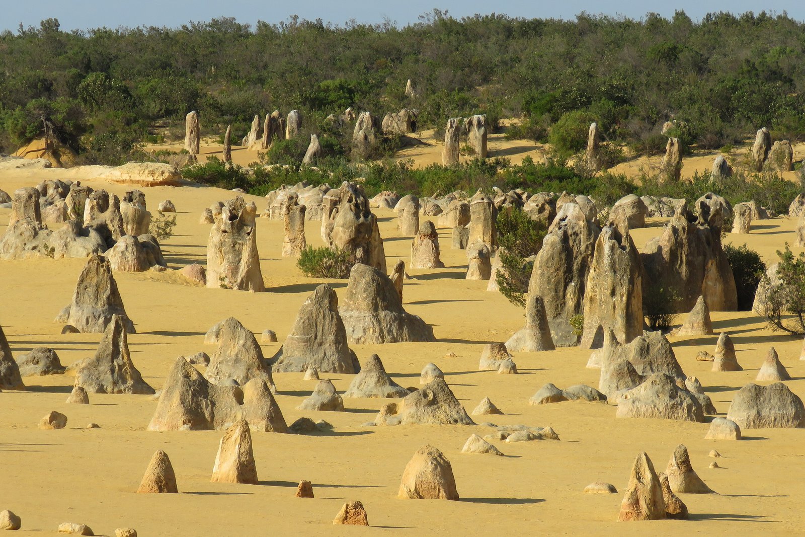
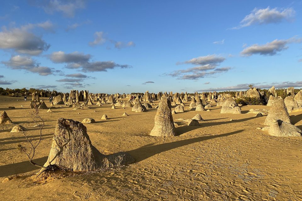
Went early, before the heat, and walked in among stone pillars standing up out of yellow sand like a crowd that had stopped to listen. Some were sharp as teeth; some were short and square as old headstones. A kangaroo grazed between them and did not look up. Beyond, white dunes and a line of sea. I wandered for an hour and caught myself saying excuse me to one.
The short answer
The Pinnacles are a field of thousands of limestone pillars in Nambung National Park on the Indian Ocean coast of Western Australia, 17 kilometres south of the town of Cervantes and about 200 kilometres north of Perth, by Wikipedia’s figures. The Department of Biodiversity, Conservation and Attractions (DBCA), which manages the park, describes pillars rising up to 3.5 metres from the yellow sand, some jagged and pointed, others shaped like tombstones. It recognises the Yued people as the Traditional Owners. Wikipedia’s account records that the area was gazetted as a reserve in 1967 and combined with two neighbouring reserves to form the national park in 1994.
Why it's worth knowing
The name contains two puzzles. The first is the word desert. The park authority calls the place the Pinnacles Desert, and its visitor centre and scenic drive carry the name. But DBCA’s management plan for the park describes a Mediterranean-type climate with 470 to 630 millimetres of rain a year, about 85 per cent of it falling between April and September. Wikipedia’s article on deserts gives the usual threshold as under about 250 millimetres. The Pinnacles look like a desert, bare sand with no shade, and are not one by that measure.
The second puzzle is how the pillars got there. The material is agreed: by Wikipedia’s account, which cites Lipar and Webb, seashells broken down into lime-rich sand were blown inland into high dunes that became the rock known as the Tamala Limestone. How that rock became pillars is argued. Matej Lipar (2009) and Lipar and John Webb (Earth-Science Reviews, 2015) read them as the remains of dissolution: water widened and joined vertical solution pipes in the limestone until only the pillars between them were left, and trees, they concluded, were not a major factor. Paul Hearty and Michael O’Leary (2008) are cited by Wikipedia for a different reading, pillars of hard calcrete formed around buried tree roots and exposed by the wind. A third mechanism, calcium drawn to living roots, was shown by Michael Cramer and Heidi-Jayne Hawkins (2009) for root casts in South Africa; Wikipedia notes that evidence for it at the Pinnacles is still lacking.
The field notes
A clock made of iron
In October 2024 a team led by Lipar published in Science Advances a date for the dissolution. They studied small, rounded, iron-rich nodules (ferricrete) on and around the pinnacles, so small, Lipar told Curtin University, that most visitors never notice them, and measured the helium produced inside them by the decay of uranium and thorium. The nodules gave an age of about 102,800 years, give or take about 11,000. The Slovenian research centre ZRC SAZU, where Lipar works, reported the authors’ reading: the date falls in the wettest interglacial period in the region for half a million years, the period whose rain dissolved the rock into pillars.
How tall, depending on who is measuring
The heights on offer differ. DBCA gives the tallest pillars as up to 3.5 metres. Lipar and Webb’s 2015 paper describes pinnacles up to 5 metres high and 2 metres wide, standing 0.5 to 5 metres apart. The park also warns that pillars can be top-heavy and unstable, and may fall over at any time.
Noticed late
Dutch maps of 1658 recorded hills on this coast, the North and South Hummocks, by Wikipedia’s account, and the area stayed little known until it was surveyed in 1934. Wikipedia describes the pinnacles as unknown to most Australians until the reserve of 1967. The Pinnacles Desert Discovery Centre, with displays on the geology and on the area’s cultural and natural heritage, opened in 2008. Western grey kangaroos graze among the pillars, usually in the early morning, and emus are frequently seen, Wikipedia’s account says.
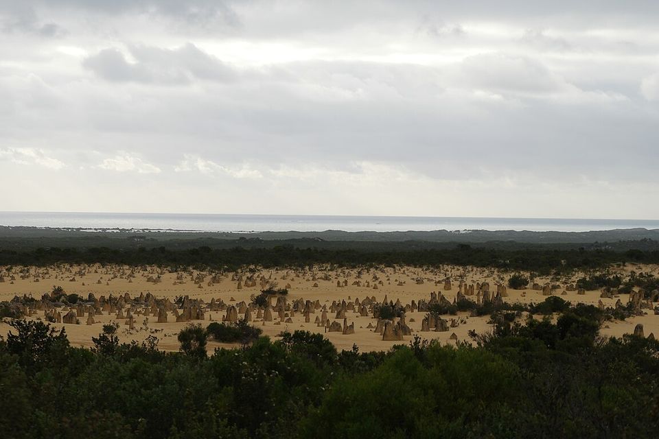
The Pinnacles field from the heath above, with the Indian Ocean on the horizon, November 2015.
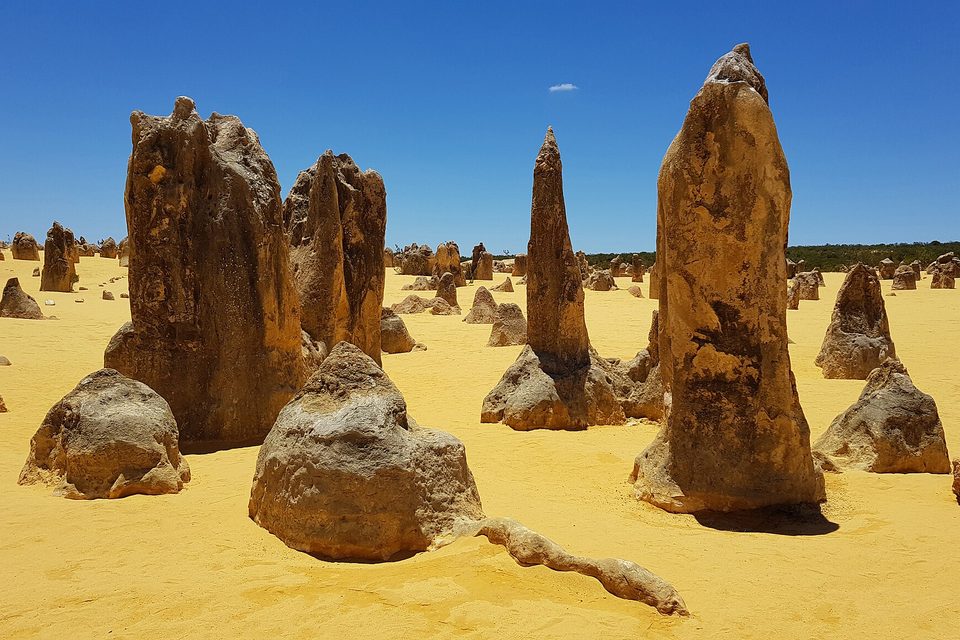
Tall limestone pillars under a clear summer sky, January 2018.
Photograph: Anagoria · 2018-01-31 The Pinacles, Nambung National Park, West Australia anagoria 02 · CC BY 3.0 · cropped
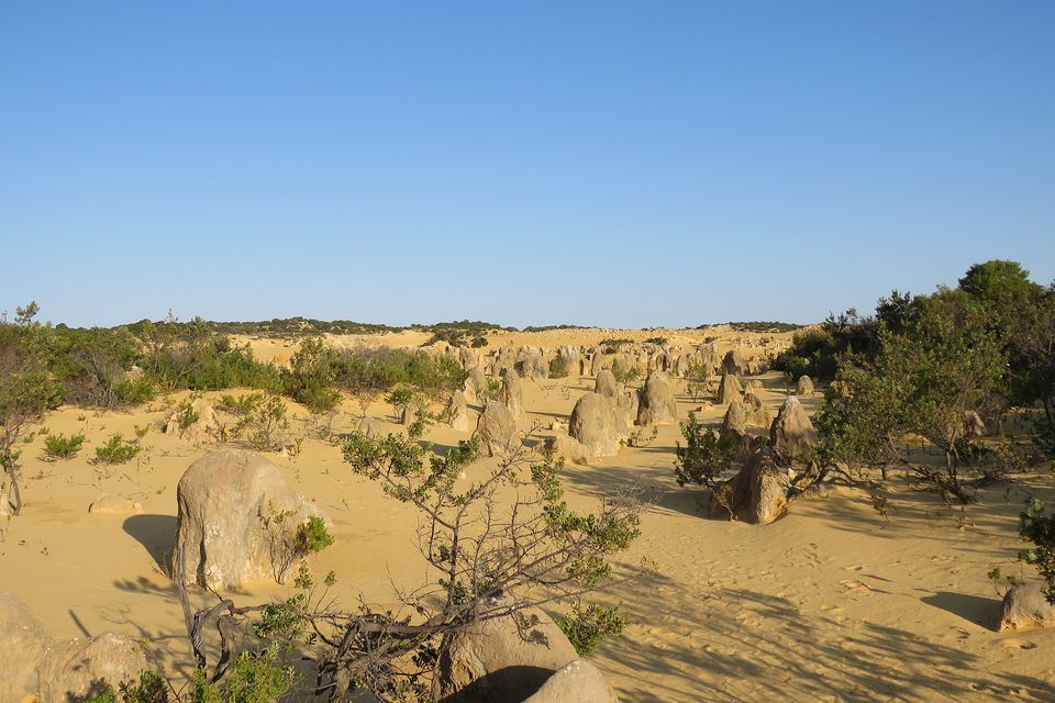
Coastal heath and pillars in the evening sun, September 2023.
Photograph: Calistemon · CC BY-SA 4.0 · cropped
Walkers among the pillars in the late sun, February 2023.
Photograph: -wuppertaler · CC BY 4.0 · cropped
- Come early or late, when the pillars throw long shadows and the kangaroos are about.
- Leave the car where the drive lets you stop, and walk in among them. Touch nothing and climb nothing.
- Start at the centre, and learn whose country it is before you go wandering in it.
- Come back in the flowering months, when the scrub around the pillars is in bloom.
- Say good morning to a kangaroo, and do not expect an answer.
Arrived with five items. Leaving with nine, one of them an apology to a rock.
An iron nodule on a limestone pillar. Small, rounded knobs of iron-rich rock sit on and around the pinnacles, small enough to walk straight past. In 2024 Lipar and colleagues measured the helium locked inside them, left by the decay of uranium and thorium, and dated them to about 102,800 years ago, which the authors read as the wet spell when rain dissolved the limestone into pillars. The nodules had been sitting on the evidence all along, and they are how the pillars were finally given a date.
Tally, in the marginLittle brown freckles on the pillars, and it was the freckles that were keeping the date. Note to self: next time, ask the small ones first.
Getting there
How to get there. The Pinnacles are about 200 kilometres north of Perth by Wikipedia’s figure, reached by the Indian Ocean Drive or by Cervantes Road from the east, and 17 kilometres south of Cervantes, the nearest town with accommodation. There is no lodging or camping in the park.
At the park. Entry needs a park pass, which DBCA sells at outlets including the Pinnacles Visitor Centre in Cervantes. The Pinnacles Desert Discovery Centre opens daily from 9:30 to 16:30 except Christmas Day. A one-way drive of 4.5 kilometres winds through the pillars, with places to stop and walk in among them, and a walking trail starts from the centre. The park authority asks visitors never to climb on the pillars, which it describes as fragile, and warns that they can topple.
When to go. DBCA and Wikipedia both recommend August to October, when the days are mild and the wattles and wildflowers bloom. Early morning and late afternoon bring long shadows and the kangaroos.
Safety. The State Department has Australia at Level 1, exercise normal precautions, with no area-specific warnings.
Mark this place
Common questions
How were the Pinnacles formed?
The Pinnacles in Western Australia are made of Tamala Limestone, formed from shell-rich sand blown inland into dunes. How that rock became pillars is debated: Lipar and Webb (2015) explain them as remnants left by dissolution around widening solution pipes, while Hearty and O’Leary (2008) are cited for pillars of calcrete formed around buried tree roots.
Is the Pinnacles Desert a desert?
Not by rainfall. The Pinnacles in Nambung National Park are called the Pinnacles Desert, but the park’s management plan describes a Mediterranean-type climate with 470 to 630 mm of rain a year, well above the usual desert threshold of about 250 mm. The name describes the bare yellow sand, not the climate.
How tall are the Pinnacles?
The Pinnacles in Nambung National Park rise up to 3.5 metres, according to Western Australia’s parks department. Lipar and Webb’s 2015 study describes pinnacles up to 5 metres high and 2 metres wide, standing 0.5 to 5 metres apart.
Where are the Pinnacles?
The Pinnacles are in Nambung National Park on the Indian Ocean coast of Western Australia, 17 km south of the town of Cervantes and about 200 km north of Perth. They are reached by the Indian Ocean Drive, and the park’s Pinnacles Desert Discovery Centre stands where the walking trail among them begins.
How old are the Pinnacles?
A 2024 study in Science Advances, led by Matej Lipar, dated small iron-rich nodules on the Pinnacles to about 102,800 years ago. The authors read the date as the wettest interglacial in the region for 500,000 years, when rain dissolved the Tamala Limestone into pillars. The limestone itself is older.
Can you drive through the Pinnacles?
Yes. The Pinnacles Desert Lookout and Drive in Nambung National Park is a one-way loop of 4.5 km through the pillars, with places to stop and walk among them. Entry needs a park pass, and the park authority asks visitors never to climb on the fragile pinnacles, which can topple.
When is the best time to visit the Pinnacles?
Western Australia’s parks department and Wikipedia both recommend August to October for the Pinnacles, when the days are mild and the wildflowers and wattles bloom. Early morning and late afternoon give long shadows, and western grey kangaroos usually graze among the pillars early in the day.
Who are the Traditional Owners of Nambung National Park?
Western Australia’s Department of Biodiversity, Conservation and Attractions recognises the Yued people as the Traditional Owners of Nambung National Park, where the Pinnacles stand. The Pinnacles Desert Discovery Centre covers the area’s cultural as well as natural heritage.