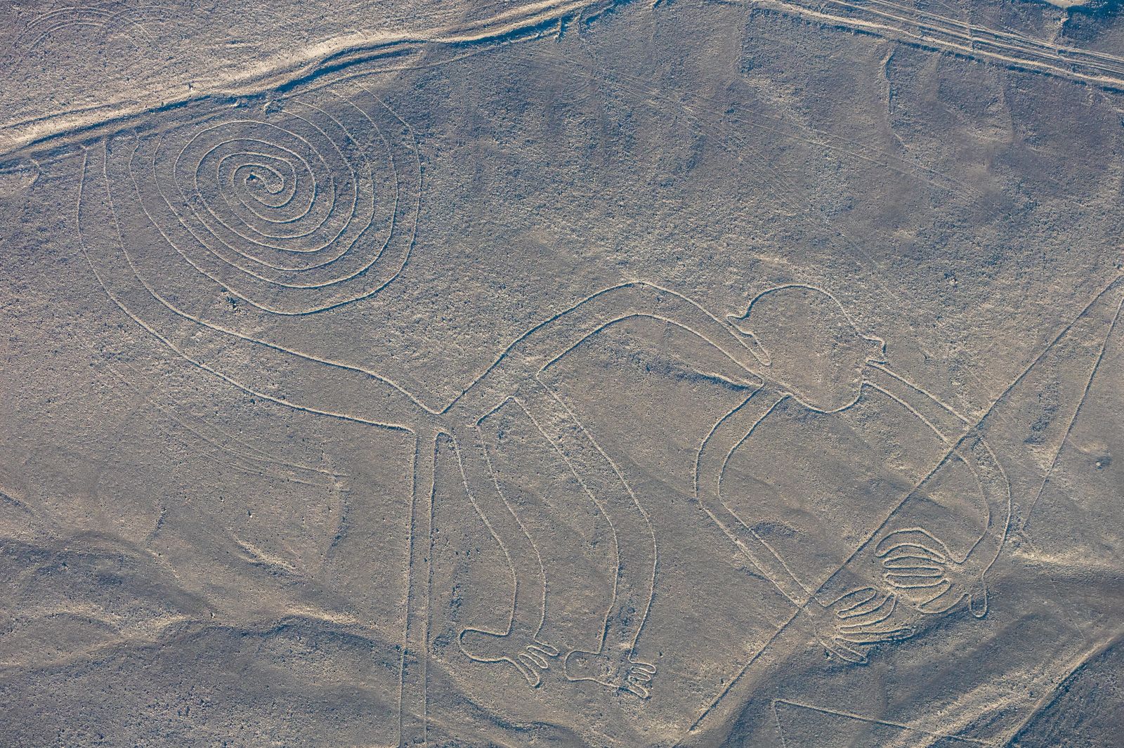

- Where
- Pampas de Jumana, southern Peru
between Nazca and Palpa - Coordinates
- 14.7390° S
75.1300° W - Biome
- Dry, windless stony desert plateau
on the Pacific side of the Andes - Made
- Between about 500 BC and AD 500
by removing surface pebbles - Extent
- More than 1,300 km of lines
largest figures about 370 m long - Status
- UNESCO World Heritage, 1994
- Best seen
- From the air (about 500 m)
or from nearby hills
Went up in a very small aeroplane over a plain the colour of old biscuit, with nothing on it but scoured stones and long dead-straight scratches. Then the plane tilted, somebody said “there”, and the ground had drawn a bird, and then a spider, and then a creature with its arms in the air, waving. Back on the ground I looked at the same plain and saw only stones.
The short answer
The Nazca Lines are a group of geoglyphs made in the soil of the Nazca Desert in southern Peru, on a high, arid plateau that stretches more than 80 kilometres between the towns of Nazca and Palpa, about 400 kilometres south of Lima. They were made between about 500 BC and AD 500 by removing the reddish-brown, iron-oxide-coated pebbles that cover the surface, which exposes a paler subsoil beneath. Most lines run straight across the landscape; others form figures — more than 70 animals, including a hummingbird, a spider, a condor and a monkey — and the largest figures are about 370 metres long. The combined length of all the lines is more than 1,300 kilometres. UNESCO inscribed them in 1994.
Why it's worth knowing
Most people know the Nazca Lines as a mystery, and the best-known answer to it, that ancient astronauts made them, was set out by Erich von Däniken in 1968 and has not survived the evidence. In 1982 the American investigator Joe Nickell, with family and friends, reproduced the 134-metre condor full size on a field in Kentucky, scaling up a small drawing with stakes and string and no view from the air, in a matter of days; he reported it in the Skeptical Inquirer in 1983.
The interesting mystery is quieter. Why make drawings on a scale that only reads from the air? The answers on offer are astronomical markers (Paul Kosok and Maria Reiche), water-and-mountain ritual (Johan Reinhard), lines that follow aquifers (David Johnson), a link to the temples at Cahuachi (Nicola Masini and Giuseppe Orefici), and, in the 2024 AI-assisted survey, a division of labour: the large line-type figures, mostly wild animals, as the setting for ceremonies during pilgrimages, and the smaller relief-type figures, mostly people and livestock, placed to be seen from walking trails. None of them has beaten the others, and the astronomical case took a knock: in 1990 the archaeoastronomers Gerald Hawkins and Anthony Aveni concluded that the evidence was insufficient to support it.
And the picture is still growing. In 2024 a team from Yamagata University’s Nazca Institute, working with IBM Research, used artificial intelligence to sort aerial photographs and then sent people out on foot to check. Between September 2022 and February 2023 they confirmed 303 previously unknown figurative geoglyphs — parrots, cats, monkeys, killer whales, and severed heads — in 1,440 hours of field labour. The lines are an archive that is still being read.
The field notes
How they were made
Most of the lines are shallow trenches, 10 to 15 centimetres deep, made by lifting the dark pebbles off the surface. The exposed subsoil is light-coloured and contains a good deal of lime, which hardens when morning mist wets it and forms a crust that protects the lines from the wind. Together with the dry, windless, stable climate, that is why they survive. More than half of the lines are a little over 33 centimetres wide, though the range is from about 30 centimetres to 1.8 metres, and most figures are drawn in one continuous line.
Archaeologists have found wooden stakes in the ground at the ends of some lines, which supports the idea that the makers used simple surveying methods. One stake was radiocarbon-dated, and that date is the basis for the age of the whole complex. Two phases are recognised: the Paracas phase, 400 to 200 BC, and the Nazca phase, 200 BC to AD 500. The first systematic field study, begun in 1996 by Markus Reindel and Johny Cuadrado Isla, has documented and excavated more than 650 sites and dates the figurative motifs to 600 to 200 BC, which is earlier than the Nazca phase.
Finding them
The first published mention is by the Spanish conquistador Pedro Cieza de León, in 1553, who took the lines for trail markers. The twentieth-century story begins with pilots, and with the Peruvian archaeologist Toribio Mejía Xesspe, who spotted them from the foothills in 1927. Paul Kosok, an American historian studying ancient irrigation in 1940–41, flew over them and saw that one was a bird; with Maria Reiche, a German mathematician and archaeologist from Lima, he proposed that they were astronomical markers.
Since 2006 a Japanese team from Yamagata University has been doing fieldwork there. It announced about 100 new geoglyphs by 2012, 143 more with IBM Japan in 2019 (one found by machine-learning methods), and the 303 of 2024. A cat figure on a steep hillside was found in 2020. One published tally counted 358 known Nazca geoglyphs in 2022. In 2018 drones revealed 25 geoglyphs in the Palpa province that are assigned to the earlier Paracas culture, many of them a thousand years older than the Nazca lines, some showing warriors.
What it takes to keep them
The lines are shallow and the desert is fragile. Mudslides after flooding in February 2007 did not, in the assessment of Peru’s National Institute of Culture, cause significant damage. Other incidents have: squatters occupied land in the area in 2012 and damaged a Nazca-era cemetery; machinery from a limestone quarry was reported to have destroyed a small section of a line in 2013; in December 2014 Greenpeace activists set up a banner within the lines of one geoglyph and damaged the site, for which Greenpeace apologised and one activist was convicted and fined; and in January 2018 a truck driver left tyre tracks across three geoglyphs. Off-road vehicles from the Dakar Rally damaged geoglyphs outside the World Heritage area in 2012 and 2013.
In 2025 the Ministry of Culture ordered the area of the Nazca Lines reserve reduced by 42 per cent, from about 5,600 to about 3,200 square kilometres, citing updated archaeological studies. The reduction was criticised amid concerns about informal mining, and the ministry reversed it shortly afterwards.
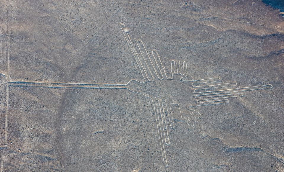
The hummingbird, 93 metres long, drawn in one unbroken line.
Photograph: Diego Delso · CC BY-SA 4.0
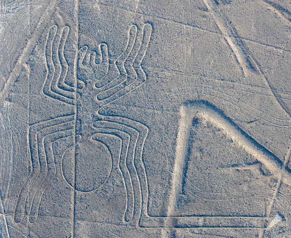
The spider, 47 metres long.
Photograph: Diego Delso · CC BY-SA 4.0
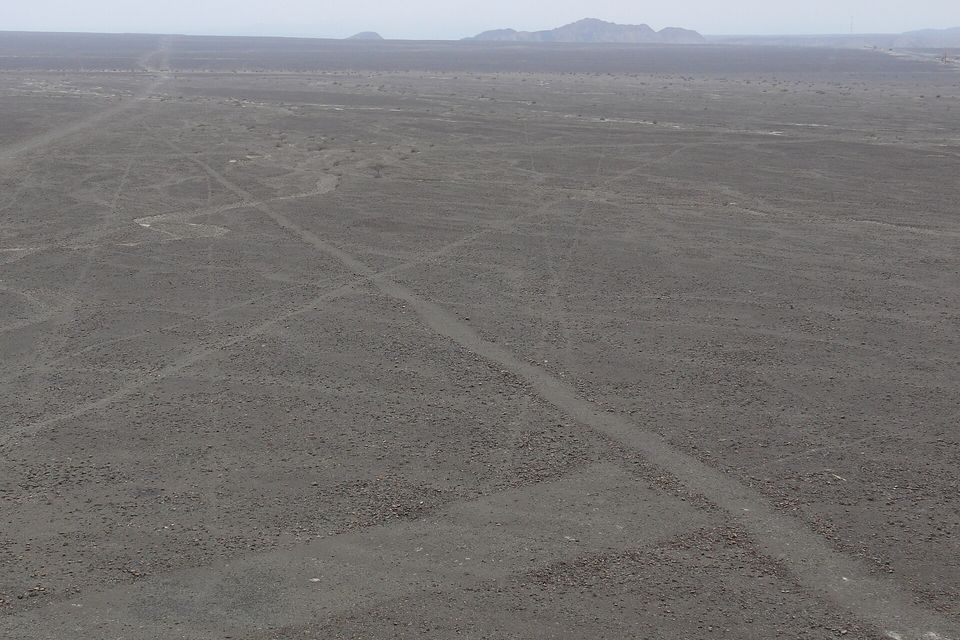
The same desert from a hill: the lines are faint scratches at ground level.
Photograph: Max Berger · CC BY-SA 4.0 · cropped
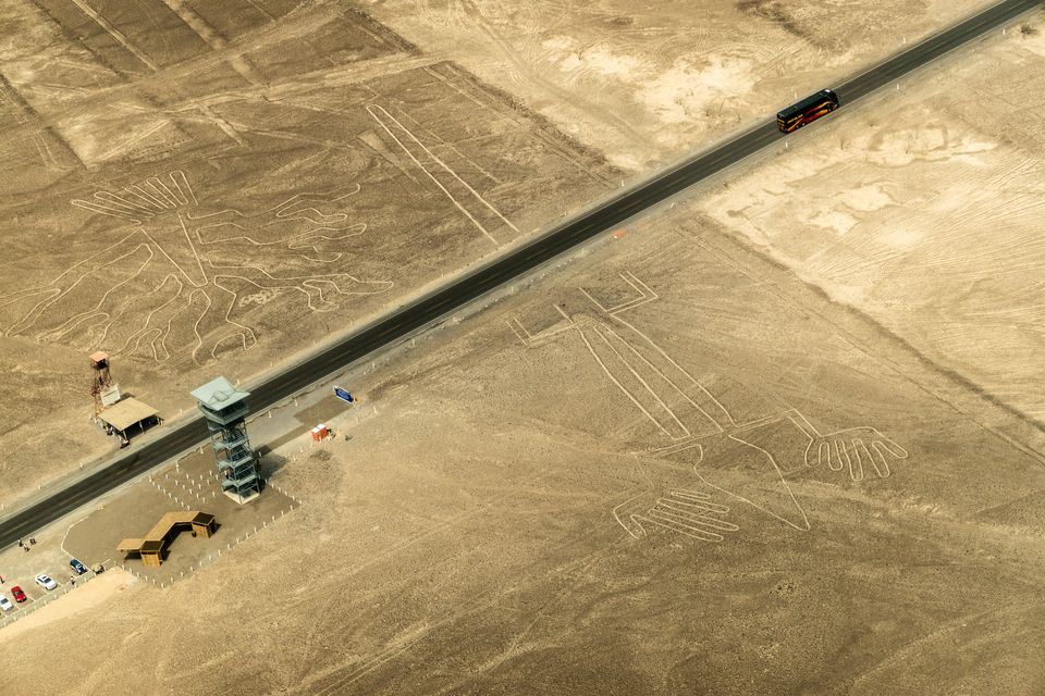
The Pan-American Highway and the roadside viewing tower beside the Tree and the Hands.
Photograph: PsamatheM · CC BY-SA 4.0
- Go up in the little plane, and take something for your stomach before you board, not after.
- Stay off the lines. They are somebody’s drawing.
- Find a high place and try to see one from the ground. Then be grateful for the plane.
- Ask your guide what the lines were for, and then what they would bet.
- Wave back at the one who is waving. (Added in the air. Completed in the air. A personal record.)
A wooden stake. At the ends of some of the lines, archaeologists have found wooden stakes in the ground, which supports the idea that the makers used simple surveying. According to the account Wikipedia gives, one of them was radiocarbon-dated and became the basis for dating the complex; later fieldwork by Markus Reindel and Johny Cuadrado Isla dates the figures by comparing them with the pottery of the cultures that made them. Nobody should walk out looking for a stake: the lines are shallow trenches in a fragile surface, and feet and tyres have damaged them before.
Tally, in the marginOne stick in the ground, and everybody’s dates hang from it. I have looked at a great many sticks and I now feel I was careless with them.
Getting there
How to get there. The lines lie about 400 kilometres south of Lima along the Pan-American Highway (the PE-1S), which runs parallel to the plateau. Long-distance buses and drivers work the route from Lima; allow most of a day and plan to travel in daylight. The town of Nazca is the base for flights and viewing.
How to see them. The shapes are best seen from the air, at about 500 metres, and that means a sightseeing flight in a small aeroplane from the Nazca area. Ask the operator about the aircraft, the pilots and the safety record before you book, and expect banking turns: bring something for motion sickness. The lines are also visible from the surrounding foothills and other high places, which suits anyone who does not want to fly, but you will see far less of the figures. Do not walk on the lines.
When to go. It is a desert with a dry, windless, stable climate, so visits are possible year-round; ask the operator when the calmest flights are, since wind and heat shake small aircraft.
Practical notes. Peru is at Level 2 for crime, civil unrest and the risk of kidnapping. Nazca is in the Ica Region, which is not among the Level 4 areas the State Department names, and the advisory notes that criminal groups sometimes set up roadblocks outside Lima and that road safety is a concern, which is a reason to travel by day with an established bus company or driver. Demonstrations can close highways with no warning, so leave slack in the schedule.
Mark this place
Common questions
What are the Nazca Lines?
The Nazca Lines are geoglyphs in the Nazca Desert of southern Peru: shallow trenches, mostly 10 to 15 centimetres deep, made by removing dark pebbles to expose lighter soil. They include more than 70 animal figures, such as a hummingbird, a monkey, a spider and a condor, and many straight lines and geometric shapes, with more than 1,300 kilometres of lines in all. UNESCO inscribed them in 1994.
How old are the Nazca Lines?
They were made between about 500 BC and AD 500. Two phases are recognised, the Paracas phase from 400 to 200 BC and the Nazca phase from 200 BC to AD 500, and a carbon-dated wooden stake from the end of a line is the basis for the age. Markus Reindel and Johny Cuadrado Isla, working since 1996, date the figurative motifs to 600 to 200 BC, earlier than the Nazca phase.
How were the Nazca Lines made?
By removing the reddish-brown, iron-oxide-coated pebbles from the surface to reveal light-coloured, lime-rich soil beneath. Wooden stakes found at the ends of some lines suggest simple surveying. In 1982 the American investigator Joe Nickell and a small team reproduced the 134-metre Nazca condor full size in Kentucky, using stakes, string and a scaled drawing, in a matter of days and with no aerial view.
Why were the Nazca Lines made?
Nobody has settled it. Paul Kosok and Maria Reiche proposed astronomical markers, though Gerald Hawkins and Anthony Aveni concluded in 1990 that the evidence was insufficient. Johan Reinhard argued for rituals about water and mountains; David Johnson argued that some lines follow aquifers; Nicola Masini and Giuseppe Orefici link geoglyphs at Pampa de Atarco to the temples of Cahuachi. Erich von Däniken suggested in 1968 that visitors from other worlds made them; Joe Nickell’s 1982 full-size copy of the condor showed that no aerial help was needed.
Did AI find new Nazca Lines?
Yes. In 2024 archaeologists at Yamagata University’s Nazca Institute, working with IBM Research, used an AI model to screen aerial photographs for candidates, then confirmed 303 previously unknown figurative geoglyphs on foot between September 2022 and February 2023. The survey took 1,440 hours of labour, and the new figures include parrots, cats, monkeys, killer whales and severed heads.
Can you see the Nazca Lines from the ground?
Only partly. The shapes are best seen from the air, at around 500 metres, though they are also visible from the surrounding foothills and other high places. The largest figures are about 370 metres long, and the hummingbird is 93 metres, the monkey 93 by 58 metres and the condor 134 metres, which is why they read as drawings from above and as scratches at ground level.
How many Nazca geoglyphs are there?
It is not a fixed number. One published tally counted 358 known Nazca geoglyphs in 2022; Yamagata University and IBM Japan announced 143 new ones in 2019 and a further 303 figurative geoglyphs in 2024, and drone surveys in Palpa province found 25 more from the earlier Paracas culture in 2018. The count depends on what is counted, and on how much of the plateau has been searched.
Are the Nazca Lines protected?
They are a UNESCO World Heritage Site, inscribed in 1994, but they have been damaged repeatedly: by a quarry in 2013, by a Greenpeace banner in December 2014, by a truck in January 2018 and by Dakar Rally vehicles outside the protected area in 2012 and 2013. In 2025 Peru’s Ministry of Culture ordered the reserve cut by 42 per cent and then reversed the decision after criticism.