
Part of The US National Parks
- Where
- Cascade Range, southern Oregon
Crater Lake National Park - Coordinates
- 42.9442° N
122.1089° W - Depth
- 592 m (1,943 ft)
(National Park Service) - Formed
- About 7,700 years ago
(collapse of Mount Mazama) - Water
- Rain and snow only
no stream in or out - Shore access
- Closed 2026–2028
(Cleetwood Cove Trail rebuild) - Advisory
- United States
(no State Department level)
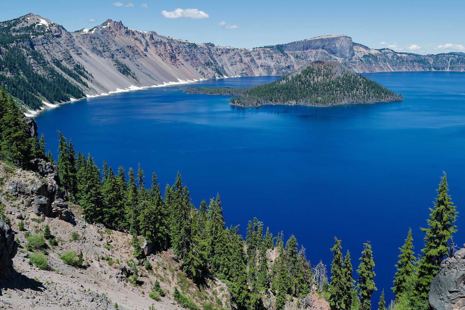
Snowbanks taller than the car in summer, dark pines, then the edge of a hole where the top of a mountain ought to be, brimming with the deepest blue I have ever stood above. A small cone sat in it with a dent in its own top. I never got down to the water. I walked the rim instead, and looked at it from every side but the wet one.
The short answer
Crater Lake is a lake inside the caldera of a collapsed volcano in the Cascade Range of southern Oregon, and the centre of Crater Lake National Park, established on 22 May 1902 and, by Wikipedia’s count, the fifth-oldest national park in the United States. The volcano, Mount Mazama, had its greatest eruption about 7,700 years ago, which the National Park Service calls the largest in North America in more than half a million years; its summit fell in, and rain and snow slowly filled the hole. No streams flow in or out. The Park Service gives the lake’s depth as 1,943 feet (592 metres), the deepest in the United States. Wizard Island, a cinder cone that erupted after the collapse, rises from the water near the western shore. The Klamath Tribes, whose homeland this is, call the lake giiwas.
Why it's worth knowing
Crater Lake is a lake made of weather. With no river feeding it and none draining it, its level is a running balance: the Park Service’s long-term monitoring reports describe an average supply of about 224 centimetres (88 inches) of rain and snowmelt a year, set against evaporation from the surface and seepage through a thick layer of permeable glacial till in the caldera wall, which the reports call a “bathtub drain”.
Most of that supply arrives as snow. The Park Service gives an average of 42 feet a winter at park headquarters and more than 50 feet at Rim Village, and calls the park one of the snowiest inhabited places in America. Its weather records, kept for a century, also show the snow thinning: an average of 614 inches a year in the 1930s, and 421 since 2010. The lake is the product of that snow, and the Park Service follows both.
For three summers, the lake is also out of reach. The Cleetwood Cove Trail, 1.1 miles down the caldera wall, is the only route to the shore. The Park Service has closed it for 2026, 2027 and 2028 to rebuild the trail, its retaining walls and rockfall protection, and to replace a failed dock with a new marina. Until it reopens there is no swimming, no fishing and no boat tour, and so no landing on Wizard Island. The rest of the park, its rim roads, viewpoints and trails, stays open.
The field notes
A mountain that is not there
Mount Mazama was a tall volcano in the Cascade chain; Wikipedia’s account puts it at about 12,000 feet before its climactic eruption emptied the magma chamber beneath it and the summit collapsed, leaving a caldera that later, smaller eruptions partly floored with lava and cinder cones, Wizard Island among them. People were here to see it. Archaeologists have found sandals and other artefacts under the ash, by Wikipedia’s account, and the Park Service’s page on traditional knowledge of eruptions says the oral traditions of the Klamath and Umpqua peoples indicate that people witnessed the eruption. In the Klamath account retold on Wikipedia, the chief of the world below, Llao, fought the chief of the world above, Skell, and Llao’s mountain was destroyed.
The Klamath Tribes, which are the Klamath, Modoc and Yahooskin-Paiute peoples of the Klamath Basin, name the lake giiwas and list it among the ancestral and sacred places their site-protection programme works to protect with federal agencies.
A tree that has been standing up since 1896
A tree trunk about 30 feet (9 metres) long, most likely a mountain hemlock, floats upright in the lake with about four feet of bleached, splintered wood above the water. Wikipedia’s account traces it to the geologist Joseph Diller, who described it in a report dated 1896, and gives a preliminary carbon date of at least 450 years for the tree. It is called the Old Man of the Lake. It drifts: when its position was recorded between 1 July and 30 September 1938, it travelled at least 62 miles (about 100 km), most of it on windy days. In 1988 researchers tied it off near Wizard Island to keep it out of the way of their submarine work; the weather turned stormy and it snowed in August, and they let it go, a story Wikipedia records as the source of a local superstition.
The rim is the visit
Rim Drive runs 33 miles round the caldera, by Wikipedia’s figure, and the Park Service says the full loop is usually open only from July to October; the rest of the year the snow closes it. In 2026 the Park Service also has repairs and paving under way on East Rim Drive, and cancelled its annual car-free cycling day for that reason. Watchman Peak and Garfield Peak, short climbs from the rim, look down on Wizard Island, and Mount Scott, at 8,929 feet the highest point in the park, takes in the whole caldera.
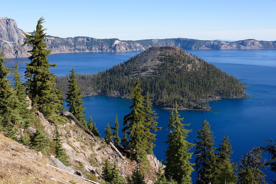
Wizard Island, a cinder cone that grew inside the caldera after Mount Mazama collapsed, October 2019.
Photograph: King of Hearts · CC BY-SA 4.0
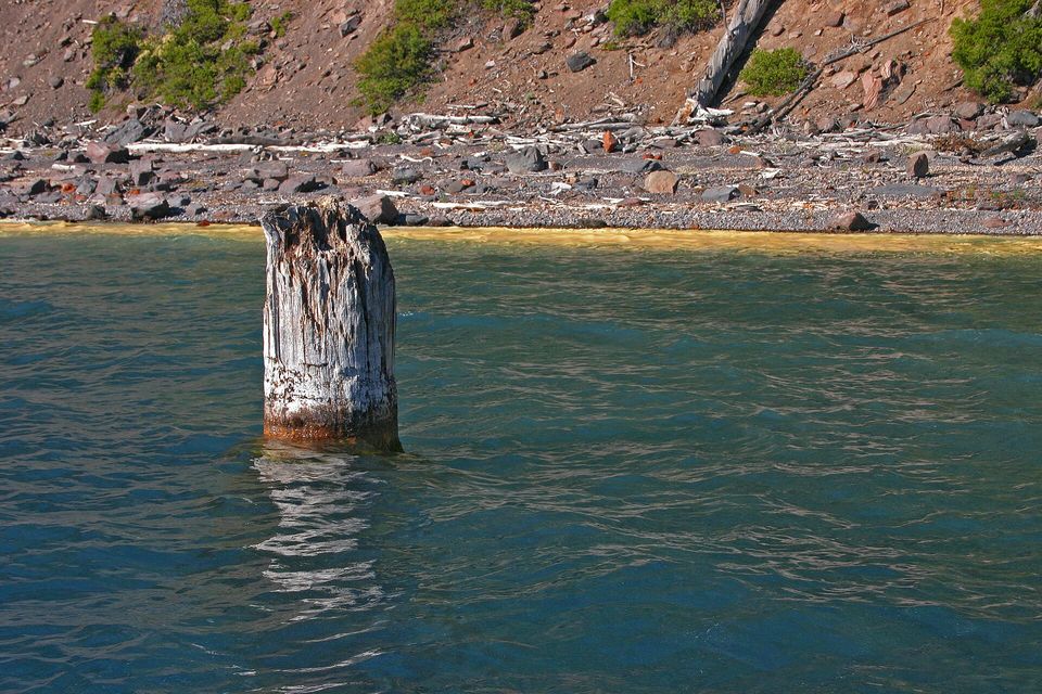
The Old Man of the Lake, a tree trunk that has floated upright since at least 1896, photographed from the water in July 2005. Boat tours are suspended while the Cleetwood Cove Trail is closed, 2026 to 2028.
Photograph: Markgorzynski · Crater Lake Old Man of the Lake · CC BY-SA 3.0
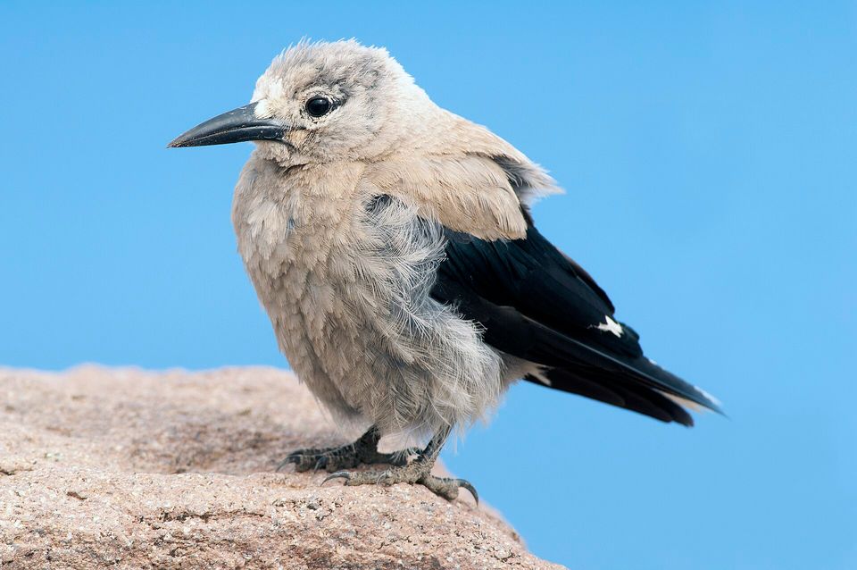
A Clark's nutcracker perched on a rock in Crater Lake National Park, June 2009.
Photograph: Yathin S Krishnappa · Nucifraga columbiana (Crater Lake, 2009) · CC BY-SA 3.0
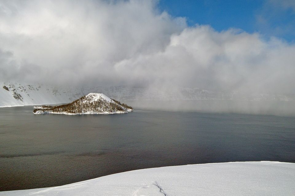
A snow squall moving across the lake near Rim Village, February 2012.
Photograph: National Park Service · Public domain · cropped
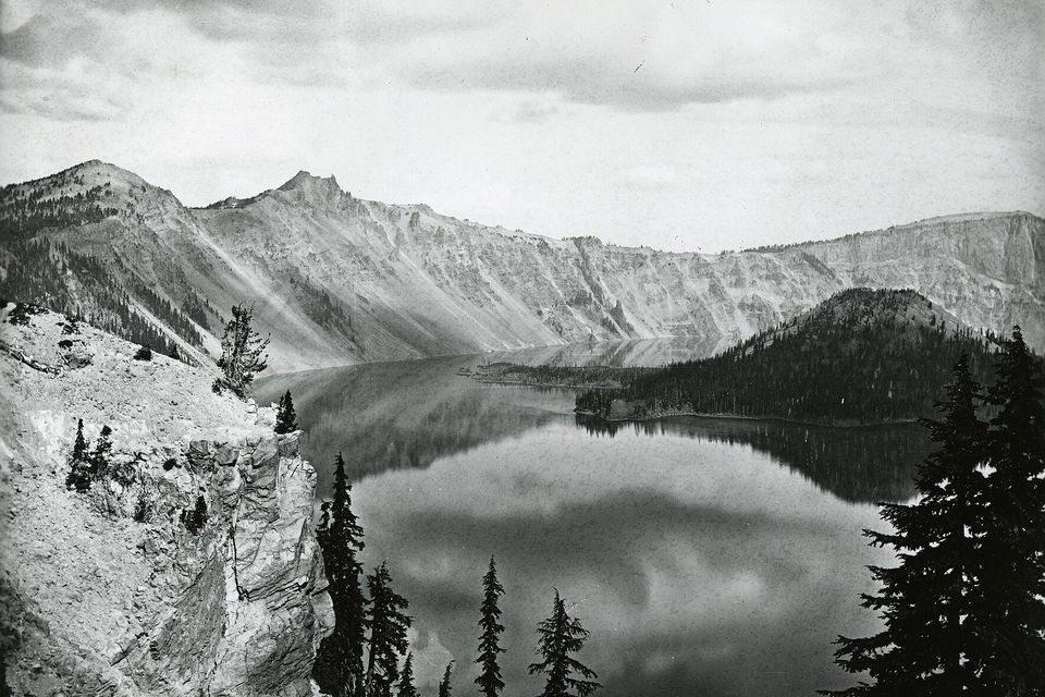
Crater Lake and Wizard Island photographed by Peter Britt in 1874.
Photograph: Peter Britt, Southern Oregon University Hannon Library · Public domain · cropped
- Come in high summer, when the road goes all the way round, and bring a coat anyway.
- Look for the old tree standing up in the water, and bring binoculars. I found a speck, and it is on the list as a speck, with a question mark.
- Speak softly at the rim, as you would in any holy place, because this is one.
- Climb one of the high points on the rim, then sit down up there and let your eyes get used to the blue before you try to describe it.
- Drink something hot at the lodge and write the colour down. You will need several words.
The Old Man of the Lake. A tree trunk about nine metres long, most likely a mountain hemlock, that has floated upright in the lake since at least 1896, when the geologist Joseph Diller wrote it into a report. About four feet of it stands above the water, bleached white and splintered at the top, and the cold water has kept the rest from rotting. It goes where the wind sends it: over three months in the summer of 1938 it travelled at least 62 miles. With the boats laid up until the trail reopens, the rim is the only place to look for it, and from the rim it is a pale speck at best.
Tally, in the marginAn old tree going wherever the wind suggests and arriving everywhere upright. I travel on much the same system, and I have never once managed the posture.
Getting there
How to get there. Crater Lake is about 62 miles (100 km) north-east of Medford and 56 miles (90 km) north of Klamath Falls, by Wikipedia’s figures, both with airports. The park is open every day of the year, the Park Service says. Highway 62 and the road up to Rim Village are ploughed all winter through the West and South entrances; the North Entrance road and Rim Drive are not ploughed from autumn to late spring. An entrance fee is charged.
When to go. July to October, when Rim Drive is usually open all the way round. Lodges and campgrounds open in summer, from about May to October; in winter the lake is a snowshoe and ski destination seen from Rim Village, and the Park Service runs ranger-led snowshoe walks.
What is closed through 2028. The Park Service has closed the Cleetwood Cove Trail and marina for 2026, 2027 and 2028. There is no way to reach the water in those years: no swimming, fishing or boat tours, and no trips to Wizard Island. Check the park’s current-conditions page before you go for the East Rim Drive works and any other closures.
Safety. The State Department issues no advisory for the United States itself. With the only trail to the shore closed, there is no legal way down the caldera walls; stay on the rim and its marked trails.
Mark this place
Common questions
How deep is Crater Lake?
The National Park Service gives Crater Lake’s maximum depth as 1,943 feet (592 metres), which makes it the deepest lake in the United States. Wikipedia gives 1,949 feet (594 metres) and notes that the figure shifts slightly with the weather, because the lake level rises and falls.
How was Crater Lake formed?
Crater Lake fills the caldera of Mount Mazama, a volcano in Oregon’s Cascade Range whose greatest eruption, about 7,700 years ago, was the largest in North America in more than half a million years, according to the National Park Service. By Wikipedia’s account the eruption emptied the magma chamber beneath the volcano and its summit collapsed; rain and snow gradually filled the basin.
Do any rivers flow into or out of Crater Lake?
No. Crater Lake has no inflowing or outflowing streams. The National Park Service’s monitoring reports describe the lake level as a balance between rain and snowmelt, about 224 cm (88 inches) a year on average, and losses to evaporation and to seepage through permeable glacial till in the caldera wall.
Can you swim or take a boat tour on Crater Lake in 2026?
No. The Cleetwood Cove Trail, the only route down to the shore of Crater Lake, is closed for 2026, 2027 and 2028 while the National Park Service rebuilds the trail and replaces the marina. Until it reopens there is no swimming, fishing or boat tour, and no trip to Wizard Island. The rim, its viewpoints and other trails stay open.
What is the Old Man of the Lake?
The Old Man of the Lake is a tree trunk, most likely a mountain hemlock, about 30 feet long, that has floated upright in Crater Lake since at least 1896, when the geologist Joseph Diller described it. About four feet shows above the water. When its position was logged in the summer of 1938, it drifted at least 62 miles in three months.
When is the best time to visit Crater Lake?
July to October is the main season at Crater Lake National Park: the National Park Service says the full Rim Drive is usually open from July through October, and lodges and campgrounds operate in summer. The park is open all year, with Highway 62 and the road to Rim Village ploughed through the winter.
How much snow does Crater Lake get?
The National Park Service gives an average of 42 feet of snow a winter at Crater Lake National Park’s headquarters and more than 50 feet at Rim Village. Its century of weather records shows a decline, from an average of 614 inches a year in the 1930s to 421 inches since 2010.
Is Crater Lake sacred?
Yes, to the Klamath Tribes, the Klamath, Modoc and Yahooskin-Paiute peoples, who call Crater Lake giiwas and include it among the ancestral and sacred sites their site-protection programme works to protect. The National Park Service says Klamath and Umpqua oral traditions indicate that people witnessed the eruption of Mount Mazama.