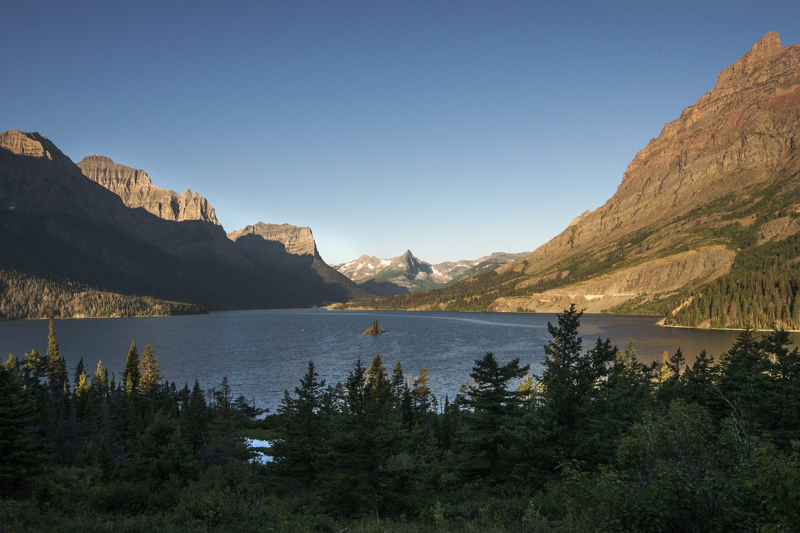
The short answer
Glacier National Park covers more than a million acres of the Rocky Mountains in north-west Montana, along the border with Canada, with the Continental Divide running down its spine. Its highest peak, Mount Cleveland, reaches 10,466 feet, and Lake McDonald, the largest of its lakes, is 464 feet deep. President Taft signed it into being on May 11, 1910, six years before the National Park Service existed. With Canada’s Waterton Lakes National Park it forms Waterton-Glacier International Peace Park, the world’s first.
From Tally’s diary
The wind came over the top of the range so hard I had to lean on it, and minutes later it was warm, as if somebody had opened an oven door in the middle of the snow. The lake was full of coloured stones, red and green and purple, lying still under the water as if waiting to be chosen. I chose none. It seemed unfair to the others.
Inside the park
- Going-to-the-Sun Road
The road over the Continental Divide at Logan Pass, and the long story of how it was cut into the cliffs.
Photograph: NPS, Public domain

Why it's worth knowing
A rainbow from an ancient sea. About 1.5 billion years ago a shallow inland sea, the Belt Sea, covered this corner of the continent, and year by year its floor filled with mud and sand that hardened into the park’s rock. The colours come from iron. Where the mud met air, the iron rusted to red and purple; where it lay starved of oxygen under water, it turned to green and blue. Ripples and mud cracks from that sea floor are still visible above the treeline, and the colours turn up everywhere, from whole mountainsides to the pebbles in Lake McDonald.
Old rock on top of young. Sixty to seventy million years ago, movement on a great fault, the Lewis overthrust, pushed this ancient rock up and over much younger rock, a slab of it about two miles thick. Chief Mountain stands on its eastern edge. Then, from about two million years ago, Ice Age glaciers filled the valleys and carved the craggy ridges, peaks and amphitheatres. As a result the park’s rocks are either very old or fairly young, with a gap of more than 800 million years between them.
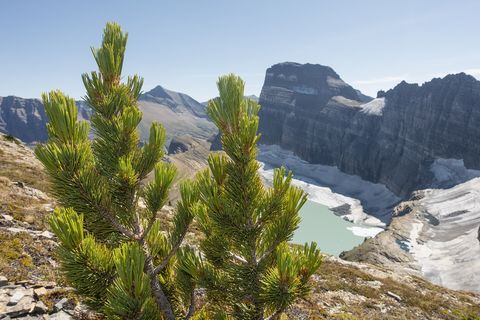
The ice it is named for. At the end of the Little Ice Age, around 1850, there were about 80 glaciers in what became the park. Aerial images from 2015 counted 26 named glaciers still big enough to qualify, nine fewer than in 1966, and every named glacier shrank between 1966 and 2015, some by more than 80 per cent. Most of those left hide in shadowy niches high on the Continental Divide, so the park is not the easiest place to see one; late August and early September, when the winter’s snow has gone, is the best time to tell glacier from snowfield. Only North Cascades National Park holds a higher concentration of glaciers in the lower 48.
The field notes
The place where there is a lot of ice
The lands of the park are part of the history and culture of the Blackfeet, Salish, Pend d’Oreille and Kootenai tribes. The Kootenai have long called the area Ya·qawiswit̓xuki, “the place where there is a lot of ice”, and other tribes speak of it as “the land of the shining mountains”, for the bright snow and ice seen from the plains to the east. The English name came later. In 1906 the geologist François Matthes wrote to the conservationist George Bird Grinnell, who had been exploring the valleys since 1885, that a park of some 1,500 square miles, with more than 50 bodies of ice and over 200 lakes, “might fitly be called Glacier Park.” Grinnell had already given the region another name: the “Crown of the Continent”.
One peak, three oceans
Rain that falls on the east side of the Continental Divide here runs to the Missouri, the Mississippi and the Gulf; rain on the west side runs to the Columbia and the Pacific; and in the north-east of the park, the rivers flow toward the Saskatchewan and Hudson Bay. All three meet at a single point on Triple Divide Peak in the Lewis Range, a mountain that looks unremarkable and sends water toward three different oceans.
Weather with a temper
The park straddles a meeting of two climates: warm, wet Pacific air from the west, and cold, dry Arctic air from the north-east. On the east side, downslope gusts often top 50 miles an hour and sometimes reach 100, and in winter a chinook, the “snow-eater”, can lift the temperature more than 30°F in minutes. When Arctic air spills over the Divide into Pacific moisture, the result can be a blizzard; one dropped 44 inches of snow in a single day. Some mountain cirques get 100 inches or more of precipitation a year.
The first peace park
In 1932, after a campaign by the Rotary Clubs of Alberta and Montana, the US Congress and the Canadian Parliament joined Glacier and Waterton Lakes as the world’s first international peace park. UNESCO named the park a biosphere reserve, and in 1995 named Waterton-Glacier a World Heritage Site. In 2017 the two parks became an International Dark Sky Park together, the first such designation in the world to cross a border. No other place in America holds all four.
No granite at Granite Park
Granite Park Chalet, high on the Divide, is named for rock that early prospectors took for granite. There is no naturally occurring granite anywhere in the park: what they saw was either ancient pillow lava, which is basalt, or the Purcell Sill, a dark band of rock that once forced its way between limestone layers as magma and baked the stone around it into white marble.

August 2021A whitebark pine above Grinnell Glacier and its lake.
Photograph: NPS, Public domain

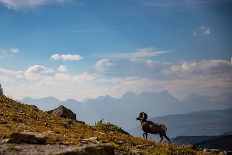
September 2021A bighorn ram on a high slope.
Photograph: NPS, Public domain

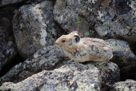
July 2021An American pika on an alpine rock slope.
Photograph: NPS, Public domain, cropped
- Find a glacier, a proper one, not a snowfield pretending. (Found four snowfields. Each was very convincing. The list has them on probation.)
- Stand near the place where the rain decides which ocean to go to, and try not to influence it.
- Lean into the east wind. (Leaned. It stopped. I did not.)
- This was home and hunting ground long before it was a park. Learn whose, and say the names properly.
- Count the colours of the stones at the water’s edge. (Got to purple, then found a second purple. The list has asked for more pencils.)
A relic from Glacier National Park
Relic, entry 331Nearly 1.5 billion years oldLooks like sliced cabbage
A stromatolite in the Altyn Formation. On the park’s east side, near Apikuni Falls, beds of limestone and dolomite nearly 1.5 billion years old hold massive mounds of fossil blue-green algae, and more outcrops show at Logan Pass and Grinnell Glacier. Cut across, they look like sliced cabbage, or the inside of a jawbreaker. Each grew layer on layer in a warm, shallow sea, trapping sediment as it went, and algae like these, breathing out oxygen, helped make the atmosphere that everything since has breathed.
Tally, in the marginA rock with cabbage in it, I thought, and was getting ready to be amused, when it dawned on me that the cabbage had once been alive and very busy, making the air. I took a long breath on the walk back, mostly as a thank-you.
Getting there
- 1
From the west
US Highway 2 runs east from Kalispell to West Glacier, about 33 miles.
- 2
From the east
Highway 89 comes north from Great Falls through Browning, about 125 miles.
- 3
By train
Amtrak’s Empire Builder stops at West Glacier and Essex all year.
- ✓
| J | F | M | A | M | J | J | A | S | O | N | D |
|---|---|---|---|---|---|---|---|---|---|---|---|
| July: best time | August: best time | September: also a good time |
- July and August bring hot days and cool nights
- The glaciers are easiest to pick out in late August and early September
How to get there. From the west, US Highway 2 runs east from Kalispell to West Glacier, about 33 miles, for Lake McDonald, Apgar and the park headquarters. From the east, Highway 89 comes north from Great Falls through Browning, about 125 miles, to the three east-side entrances at St. Mary, Many Glacier and Two Medicine. Glacier Park International Airport, near Kalispell, is about 30 miles west of the West Entrance; Missoula International is about 150 miles away, and Great Falls International 130 to 165 miles from the east entrances. Amtrak’s Empire Builder stops at West Glacier and Essex all year and at East Glacier Park in season. There is no fuel inside the park. St. Mary to Many Glacier is 20 miles, and St. Mary to Canada’s Waterton Lakes National Park is 50 miles, plus customs; the Chief Mountain border crossing opens in summer only. The road across the park over Logan Pass has its own page.
When to go. July and August bring hot days and cool nights, and they are the busiest months; snow can fall at any time of year up high, and as early as mid-September lower down. Lower trails are usually clear of snow by late April or early May, but snow lingers on most high trails until mid-July. The glaciers are easiest to pick out in late August and early September.
What to arrange ahead. As of 12 November 2026, most of the park’s front-country campgrounds take reservations only, through Recreation.gov, some from six months ahead and others from four days. In summer, parking areas often fill by early morning.
Safety. The State Department’s travel advisories cover other countries, so none applies here. The Park Service names water as the leading cause of deaths in the park, and its conditions page lists closures, construction and fires.
Mark this place
The passport stamp for this place.
Common questions
Why is it called Glacier National Park?
For its ice, old and new. Glacier National Park in Montana was named for its many small glaciers, and for the great Ice Age glaciers that carved its valleys; the Kootenai name for the area means “the place where there is a lot of ice”.
How many glaciers are left in Glacier National Park?
About two dozen active ones. Aerial images from 2015 counted 26 named glaciers in Glacier National Park big enough to qualify, down from about 80 around 1850, and every named glacier shrank between 1966 and 2015.
What is the highest mountain in Glacier National Park?
Mount Cleveland, at 10,466 feet. It is one of six peaks above 10,000 feet in Glacier National Park, which has more than 150 peaks over 8,000 feet.
What is Triple Divide Peak?
A mountain in Glacier National Park that splits the rain three ways. Water on Triple Divide Peak, in Montana’s Lewis Range, flows toward the Pacific, the Gulf by way of the Mississippi, and Hudson Bay.
What is Waterton-Glacier International Peace Park?
The world’s first international peace park. Glacier National Park in Montana and Waterton Lakes National Park in Alberta were joined under that name in 1932, and became a World Heritage Site together in 1995.
How old are the rocks in Glacier National Park?
Some are about 1.5 billion years old. Glacier National Park’s red, green and purple rock was laid down as mud and sand in the ancient Belt Sea, and its oldest fossils, stromatolites, are in rock of about that age.
Is Glacier National Park good for stargazing?
Wonderfully so. Glacier National Park and Waterton Lakes National Park became an International Dark Sky Park together in 2017, the first such designation in the world to cross an international border.
When is the best time to see the glaciers in Glacier National Park?
Late August and early September. That is when most of the winter’s snow has melted in Glacier National Park, so the glaciers, tucked high along the Continental Divide, are easiest to tell from snowfields.
Photographs on this page
Tap a photograph to see it full size.
Photograph: NPS / Tim Rains, Public domain, cropped
Photograph: NPS, Public domain
Photograph: NPS, Public domain
Photograph: NPS, Public domain, cropped


