
- Where
- Central Mediterranean,
south of Sicily - Coordinates
- 35.8519° N
14.3967° E (Misraħ Għar il-Kbir) - The country
- 316 km²;
588,254 people (2025) - The ruts
- Paired grooves, typically 10–35 cm deep,
100–130 cm apart inside - Age
- Unresolved; most researchers
favour prehistory - Status
- Megalithic Temples: UNESCO,
1980 and 1992 - Best visited
- Spring and autumn;
early morning on open rock
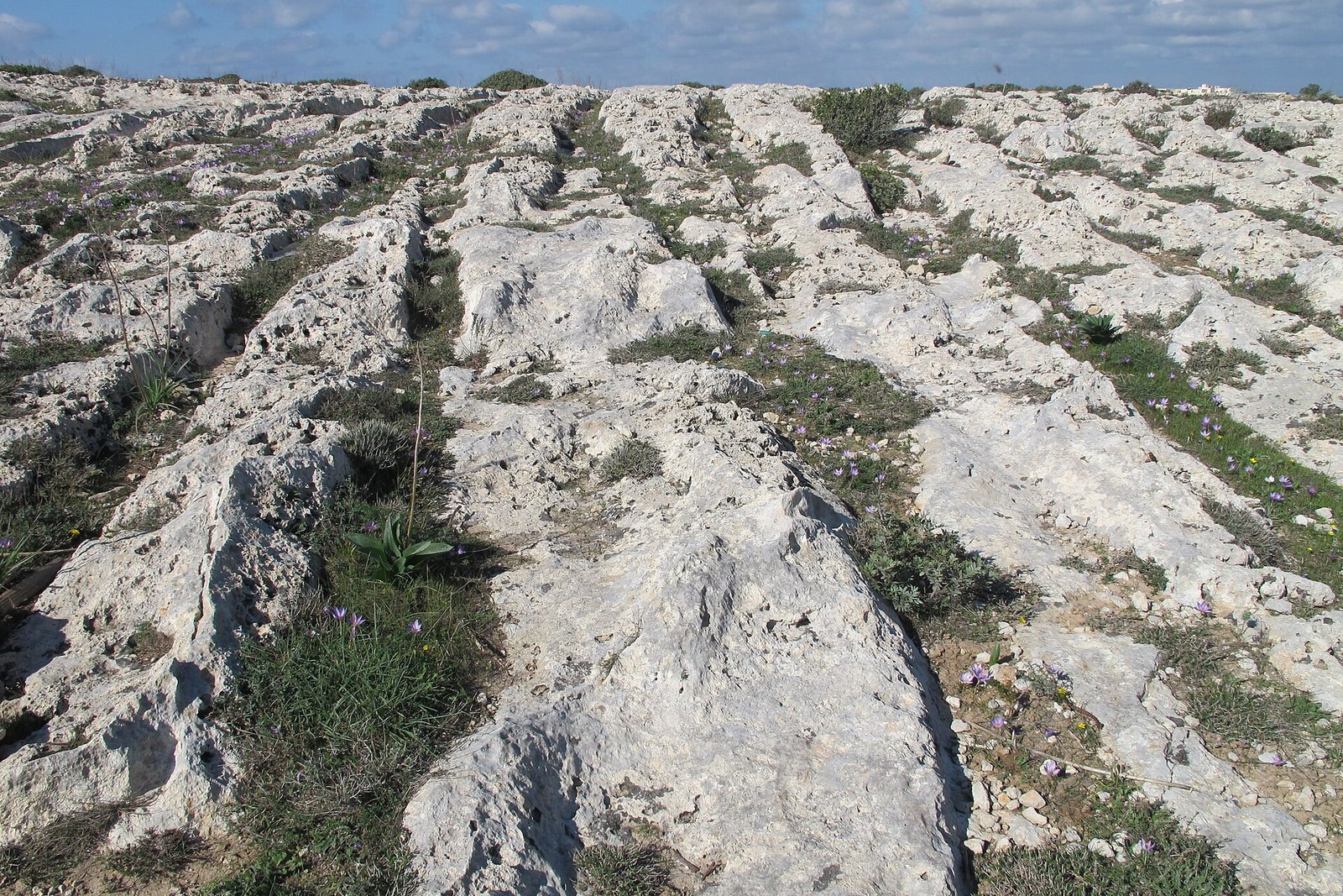
Walked out over bare pale rock near high cliffs, wild thyme in the cracks, a hot wind, and the sea very blue and a long way down. The ground was scored with pairs of grooves running side by side, crossing, forking, heading for the edge as if the traffic had kept going. Church domes on every skyline. I stood at the junction and waited, politely, for something to come.
The short answer
Malta is an island country in the central Mediterranean, south of Sicily, east of Tunisia and north of Libya: 316 square kilometres and about 588,000 people, on three inhabited islands, Malta, Gozo and Comino. It is best known to archaeologists for its megalithic temples, built between about 3600 and 2500 BC and listed by UNESCO. It is also crossed by cart ruts: pairs of parallel grooves worn or cut into the bare limestone, found across Malta and Gozo. The densest cluster is at Misraħ Għar il-Kbir, near the Dingli Cliffs in the south-west of the main island, where they cross so thickly that an archaeologist nicknamed the site Clapham Junction. What made them, and when, is one of the most argued-over problems in Maltese archaeology.
Why it's worth knowing
A cart rut looks like a question with an obvious answer. Two grooves, a steady distance apart, running across a hillside: something with wheels went this way, many times, until the rock gave in.
The trouble starts when you try to finish the sentence. A typical Maltese rut is 10 to 35 centimetres deep, with 100 to 130 centimetres between the inside edges of a pair. At Misraħ Għar il-Kbir pairs cross others or join them at junctions, which is why the site is known in English as Clapham Junction, after the busy London railway station; Wikipedia credits the nickname to the archaeologist David Trump, who wrote a book on the ruts in 2008. The University of Malta, summarising the research, gives the predominant view as prehistoric, somewhere between 5200 and 750 BC. Other estimates run as late as the Middle Ages, and nothing yet dates a rut directly.
And some of them go where no cart could follow. Ruts are recorded at St George’s Bay in Birżebbuġa, and a University of Malta study of how ruts are dated notes a pair that enters the sea and continues some distance under water. Whatever made them did so on ground that was dry at the time; the sea is higher now, or the land lower, and the tracks simply carry on underneath.
The field notes
Carts, soft rock and rain
The most developed explanation is geomorphological. In 2008 Derek Mottershead, Alastair Pearson and Martin Schaefer, in the journal Antiquity, modelled the ruts as the product of two-wheeled carts with a gauge of about 1.40 metres carrying moderate loads. In wet weather, when the soft limestone is weakest, the wheels would cut into it progressively.
Their model also explains the junctions. As a pair of ruts deepened, the cart’s body would eventually scrape the rock between them, at a ground clearance they put at about 0.675 metres, and the driver would move over a few centimetres and begin wearing a new pair. A rut network, on this reading, is a record of traffic repeatedly abandoning worn-out lanes.
How alike they are
In a study published in 2022 in the Journal of Archaeological Science: Reports, Huw Groucutt measured the variability of the ruts. The typical Maltese rut is about 15 to 30 centimetres wide at the top, narrowing to 5 to 15 at the base, and 10 to 35 centimetres deep, with typically 100 to 130 centimetres between the inside edges of a pair.
Groucutt concluded that the ruts are fairly standardised, which may suggest a consistent age and function, and noted that what standardisation means in this setting is not clear. That is the state of the question: the measurements narrow the range of answers without choosing one.
The temples, older than the questions
Malta’s megalithic temples were built between about 3600 and 2500 BC, and until the discovery of Göbekli Tepe in Turkey they were claimed as the oldest free-standing structures on Earth. UNESCO inscribed Ġgantija on Gozo in 1980 and added Ħaġar Qim, Mnajdra, Ta’ Ħaġrat, Skorba and Tarxien in 1992.
The temple-building culture disappeared around 2500 BC. Bronze Age phases followed: the Tarxien Cemetery phase, and then Borġ in-Nadur, from about 1500 to 700 BC, named after a temple and settlement site in Birżebbuġa, the same town as the ruts that run into the water.
Where to see them
Misraħ Għar il-Kbir lies in the limits of Siġġiewi, near the Dingli Cliffs and the Buskett woodland, on open, uneven rock. Ruts are also recorded at Busewdien, Naxxar, San Ġwann and Bidnija, and on Gozo. The Birżebbuġa ruts are on the shore of St George’s Bay in the south-east, near the remains at Borġ in-Nadur and the cave of Għar Dalam.
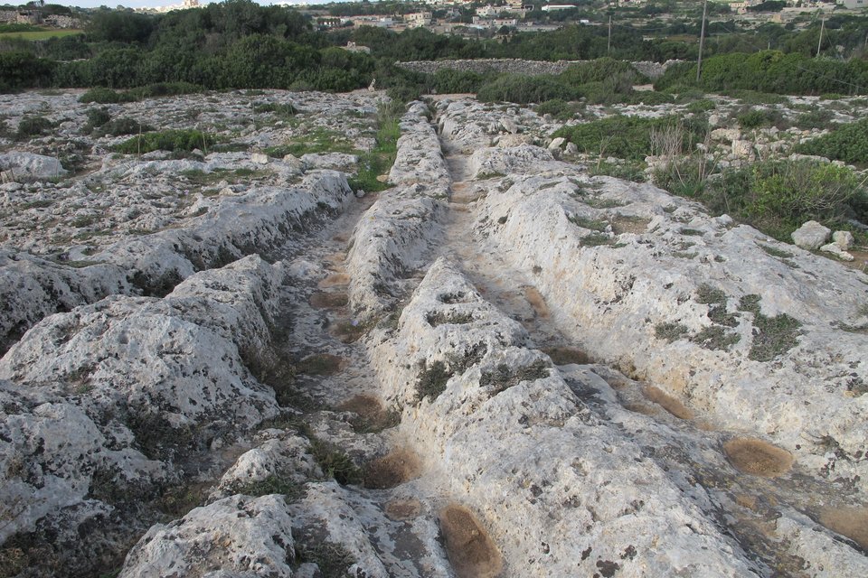
Where the ruts meet and part: the ‘Clapham Junction’ at Misraħ Għar il-Kbir.
Photograph: Kritzolina · CC BY-SA 4.0 · cropped
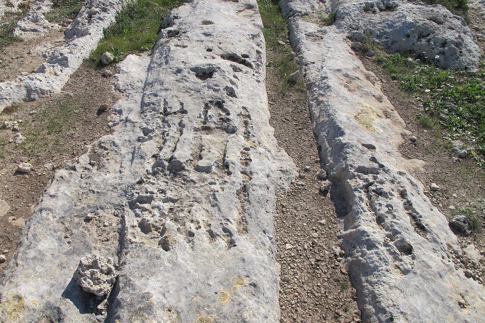
A pair of ruts at close range, the ridge of rock between them left standing.
Photograph: Kritzolina · CC BY-SA 4.0 · cropped
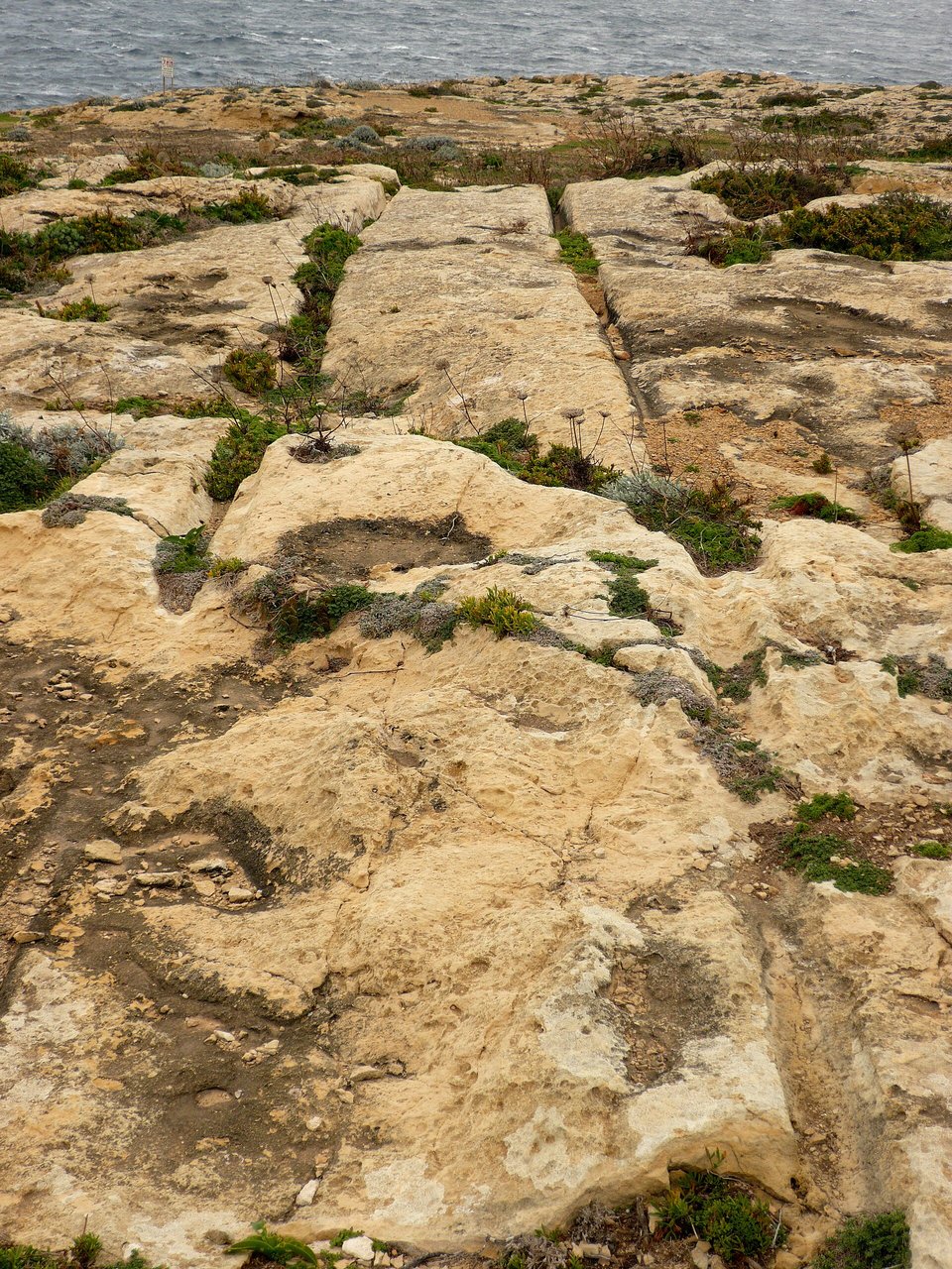
Cart ruts near Dwejra Point on Gozo, close to the sea.
Photograph: Ramessos · Public domain
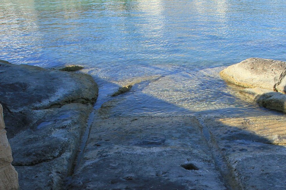
Cart ruts at St George’s Bay, Birżebbuġa, running down the rock to the water’s edge.
Photograph: Frank Vincentz · Malta - Birzebbuga - Triq Birzebbuga - St. George's Bay Cart Ruts 03 ies · CC BY-SA 3.0 · cropped
- Go early, before the rock gets hot, and take water.
- Keep to the bare rock. The fields around it are somebody’s, and they are planted.
- Stand where the grooves cross, pick one pair, and follow it as far as it goes.
- Find the pair that walks into the sea, and do not ask it to explain itself.
- Decide what made them. (Decided, then undecided, several times on the walk back. Item retained.)
The ruts that walk into the sea. Somewhere on Malta’s coast, University of Malta researchers record, a pair of cart ruts runs down the rock and carries on under the water; Wikipedia’s account of Birżebbuġa puts such ruts on St George’s Bay. Whatever made them made them on dry ground; the sea has risen, or the land has sunk, since. They are two grooves in the limestone, a steady distance apart, and they give no sign of having noticed.
Tally, in the marginTwo grooves in the rock, walking calmly down the shore and into the sea. I stood at the water’s edge for some time, waiting to see whether they would come back out.
Getting there
How to get there. Fly into Malta International Airport at Luqa, or arrive by ferry from Sicily. The island is small, and Malta Public Transport buses serve Dingli, Siġġiewi and Birżebbuġa from Valletta; a hire car or taxi is quicker for the Dingli area, where Misraħ Għar il-Kbir is a walk across open rock from the nearest road.
On the site. Misraħ Għar il-Kbir is open ground, not a ticketed monument. There is little shade and little signage, and the rock is uneven and sharp. Wear proper shoes, carry water, and keep to the bare rock; the fields around it are farmed.
When to go. Spring and autumn. In summer the open limestone is very hot by mid-morning, so go early. The ruts read best in low light, when their edges cast shadows.
With the temples. Ħaġar Qim and Mnajdra, on the south coast, are the nearest of the megalithic temples to the Dingli ruts. The Tarxien temples are near Valletta. The Ħal Saflieni Hypogeum, an underground burial site, admits a small number of visitors a day and must be booked well ahead through Heritage Malta.
At the beach. The State Department’s advisory for Malta warns that riptides have drowned tourists. Follow lifeguards’ instructions.
Mark this place
Common questions
What are the cart ruts of Malta?
Malta’s cart ruts are pairs of parallel grooves worn or cut into the islands’ bare limestone, found across Malta and Gozo. A typical rut is 10 to 35 centimetres deep, with 100 to 130 centimetres between the inside edges of a pair; at Misraħ Għar il-Kbir near the Dingli Cliffs they cross and fork in a dense network.
Why is Misraħ Għar il-Kbir called Clapham Junction?
Because its crossing and forking cart ruts look like the tracks outside Clapham Junction, the busy London railway station. Wikipedia credits the nickname for Misraħ Għar il-Kbir, in Siġġiewi in southern Malta, to the archaeologist David Trump, author of a 2008 book on the ruts. The site holds one of Malta’s most complex clusters of cart ruts.
How old are Malta’s cart ruts?
Nobody knows for certain. The University of Malta, summarising the research, gives the predominant view that Malta’s cart ruts were made in prehistory, between 5200 and 750 BC; other estimates run as late as the Middle Ages. The ruts cannot yet be dated directly.
What made the cart ruts in Malta?
The leading model, by Mottershead, Pearson and Schaefer in Antiquity in 2008, is two-wheeled carts with a gauge of about 1.40 metres, gradually cutting into Malta’s soft limestone in wet weather. When a rut grew too deep for the cart’s clearance, drivers shifted over and began a new pair.
Do Malta’s cart ruts go into the sea?
Yes. A University of Malta study of how cart ruts are dated notes a pair that enters the sea and continues some distance under water, and ruts are recorded at St George’s Bay in Birżebbuġa, in south-east Malta. Ruts under the sea were made when that ground was dry.
Are Malta’s cart ruts all the same size?
Largely. A 2022 study by Huw Groucutt in the Journal of Archaeological Science: Reports found that Maltese cart ruts are typically 15 to 30 centimetres wide at the top and 10 to 35 deep, with 100 to 130 centimetres between the inside edges of a pair, and concluded they are fairly standardised, perhaps suggesting a consistent age and function.
How old are Malta’s megalithic temples?
Malta’s megalithic temples were built between about 3600 and 2500 BC and were claimed as the oldest free-standing structures on Earth until the discovery of Göbekli Tepe. UNESCO inscribed Ġgantija on Gozo in 1980 and added Ħaġar Qim, Mnajdra, Ta’ Ħaġrat, Skorba and Tarxien in 1992.
How do you visit Clapham Junction in Malta?
Misraħ Għar il-Kbir, known as Clapham Junction, is open ground near the Dingli Cliffs in Siġġiewi, southern Malta, with no ticket or gate. It is reached by road from Dingli or Siġġiewi and a short walk over uneven rock, with little shade; spring and autumn mornings are the best time.