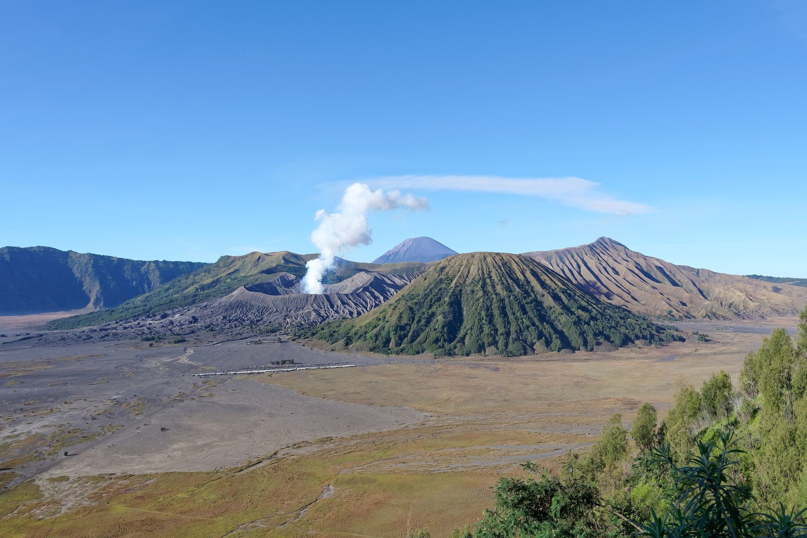

- Where
- Tengger caldera, East Java,
Indonesia - Coordinates
- 7.9431° S
112.9539° E - Height
- 2,329 m (Wikipedia);
sand floor about 2,100 m - Sand Sea reserve
- 5,250 ha, by decree
of 21 February 1919 - National park
- Bromo Tengger Semeru,
declared 14 October 1982 - Holy to
- The Tenggerese;
Yadnya Kasada offerings - Alert level
- Set by Indonesia’s
Geological Agency; check it
Up in the dark, cold enough to see my breath, and out to the rim among the pines to watch the light come. Below lay a grey sea of sand with no water in it, a smoking cone sitting in the middle and a little temple of black stone alone on the floor. Horsemen wrapped in cloth like blankets waited in the mist. I forgot to be cold.
The short answer
Mount Bromo (Gunung Bromo) is an active volcano in the Tengger massif of East Java, Indonesia, inside Bromo Tengger Semeru National Park. Wikipedia gives its height as 2,329 metres: lower than several of its neighbours, but the most active and the best known. It is one of several volcanic cones that have grown inside the Tengger caldera, the crater left by an ancient volcano whose collapse Wikipedia dates to about 45,000 years ago, and it rises from the caldera’s floor, a plain of volcanic sand that the park authority calls the Tengger Sand Sea (Laut Pasir Tengger) and that is locally called Segara Wedi. Wikipedia gives the name Bromo as the Javanese pronunciation of Brahma. The mountain is holy to the Tenggerese, and their temple, Pura Luhur Poten, stands alone on the sand below it.
Why it's worth knowing
The first thing protected here was not the volcano but the plain of sand around it, about 2,100 metres up. The national park authority’s own profile says the park grew out of the Tengger Sand Sea Nature Reserve, 5,250 hectares, designated by a decree of the Governor-General of the Dutch East Indies dated 21 February 1919; the Ranu Kumbolo reserve followed in 1936, and the national park itself was declared on 14 October 1982. The sand sea was a reserve more than a quarter of a century before Indonesia declared its independence in 1945. Wikipedia calls it the only known desert-like area in Indonesia.
It is protected ground, working ground and holy ground at once. Every morning before dawn the sand is crossed by jeeps and horses taking visitors to the crater and to the viewpoints on the rim. It is also the site of Pura Luhur Poten, which Wikipedia describes as built of natural black stone from the nearby volcanoes, where Balinese temples are mostly of red brick. Every year, at the festival of Yadnya Kasada, the Tenggerese gather at the temple and then climb to the crater to make their offerings.
And the ground is not finished. Bromo erupts. Wikipedia records that two people were killed by rocks thrown out in an eruption in 2004, and that eruptions from late 2010 into 2011 closed the area around the caldera to visitors for the rest of 2010 and spread enough ash to cancel flights to Bali, 340 kilometres to the east. Indonesia’s Geological Agency sets the volcano’s alert level, and its recommendations decide how close anyone may go.
The field notes
The cone that is not Bromo
From the most popular viewpoints on the northern rim, the most striking mountain in the caldera is not Bromo. Mount Batok, a neat, fluted cone standing in front of Bromo’s flatter, smoking crater, is, in Wikipedia’s words, often mistaken for it. Batok is the one peak in the caldera that is no longer active, and it is covered in casuarina trees. Wikipedia lists five volcanoes inside the Tengger caldera: Bromo, Batok, Kursi, Watangan and Widodaren. Beyond them to the south stands Semeru, at 3,676 metres the highest mountain in Java.
Offerings to the crater
Yadnya Kasada is the Tenggerese festival of offering. Wikipedia’s account says that on the fourteenth day of the month of Kasada in the Tengger calendar, the Tenggerese of the villages around the massif gather at Pura Luhur Poten on the sand, and then go up to the crater to throw in offerings of fruit, rice, vegetables, flowers and livestock. The Tenggerese are a Javanese people, most of whom have remained Hindu since the time of the Majapahit kingdom, and they trace their descent to the legendary couple Roro Anteng and Joko Seger. A festival for visitors, organised by the regency, is now held alongside Kasada; the offering itself is a religious rite.
Cold, high and dry
The caldera floor is high enough to be cold. Wikipedia describes the park’s climate as subtropical highland, with heavy rain in the wet season and little from May to September, when night-time temperatures often fall below freezing, with frost and occasionally light snow. The viewpoints are busiest at exactly the coldest hour, the one before sunrise.
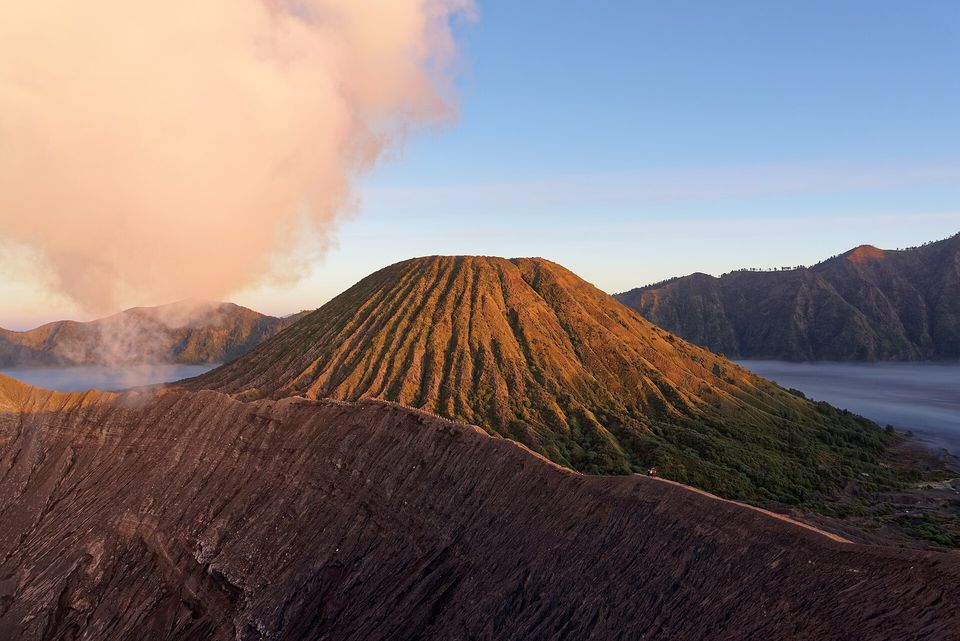
Batok, the extinct cone often mistaken for Bromo, lit by sunrise from Bromo's rim, with the caldera wall and morning mist behind, August 2022.
Photograph: Jakub Hałun · CC BY-SA 4.0
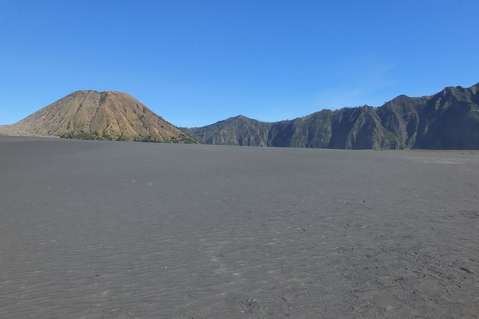
The Sand Sea at ground level: wind-rippled grey volcanic sand running to a lone cone and the green caldera wall, June 2018.
Photograph: Hugo van den Bos · Sea of Sand Bromo 01 · CC BY 2.0 · cropped
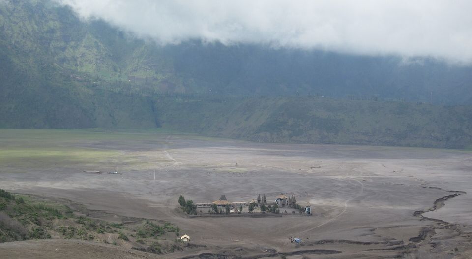
Pura Luhur Poten, the Tenggerese temple, standing alone on the Sand Sea under low cloud, November 2011.
Photograph: Ken Marshall · Poten Temple from afar · CC BY 2.0 · cropped
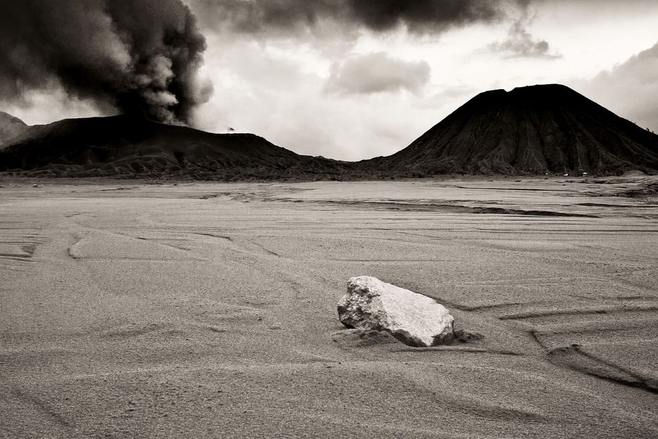
Ash rising from Bromo over the Sand Sea during the 2010 to 2011 eruption, May 2011 (photographed in black and white).
Photograph: Ronald Tagra · Sea of Sand, Bromo and Batok · CC BY 2.0
- When people carry offerings up to the crater, step aside, lower the camera and let them go by first.
- Ask what the volcano is doing before you set out, and believe the answer.
- Bring a proper coat and gloves for the dawn. Everyone without them will look at yours.
- Cross the sand on foot at least once, slowly, and listen to it.
- Watch the sunrise and add nothing to the list before breakfast. (Added three things before breakfast. One of them was breakfast.)
A casuarina cone from Mount Batok. Batok is the neat, fluted cone that stands in front of Bromo’s flatter, smoking crater on the floor of the Tengger caldera, and it is often mistaken for Bromo. It is the one peak in the caldera that is no longer active, and it is covered in casuarina trees. A casuarina’s “cone” is its woody fruit: a small head of thin, woody bracteoles holding grey or yellowish-brown winged seeds.
Tally, in the marginA small cone off the neat mountain, the one I photographed all morning in the belief that it was the famous one. The famous one was just behind it, smoking quietly, and did not seem to mind.
Getting there
How to get there. The usual base is Cemoro Lawang, a village on the northern rim of the caldera, reached by road from Probolinggo; the nearest large airports are at Surabaya and Malang. From Cemoro Lawang, Wikipedia says, it is about 45 minutes’ walk across the sand to Bromo. Many visitors hire a jeep instead, which usually includes the sunrise viewpoint on Mount Penanjakan, 2,770 metres; the viewpoint can also be reached on foot in about two hours.
Check the volcano first. Indonesia’s Geological Agency (Badan Geologi), through its volcanology centre, PVMBG, publishes Bromo’s alert level and its recommendations. At Level II, Waspada, the agency’s recommendation keeps visitors out of a 1-kilometre radius around the active crater, because of the risk of sudden steam-driven eruptions and of volcanic gas, which closes the climb to the crater rim for as long as the level lasts. The national park authority announces its own closures and restrictions. Read both before you travel, and again on the day.
When to go. The dry months, roughly May to September, are the clearest and the coldest; bring warm clothes for the dawn. Expect crowds at the viewpoints at sunrise, and at Yadnya Kasada, whose date follows the Tengger calendar.
How to be there. Pura Luhur Poten and the crater are places of worship. During Kasada, keep out of the way of people carrying offerings, and ask before photographing anyone at prayer.
Safety. The United States has Indonesia at Level 2, exercise increased caution, because of natural disasters, unrest and terrorism. The advisory names volcanic eruptions among the natural hazards and points travellers to Indonesia’s geological agency. Its only Do Not Travel areas are the provinces of Central Papua and Highland Papua, at the far eastern end of the country, more than 2,500 kilometres from Bromo by our measurement.
Mark this place
Common questions
Is Mount Bromo an active volcano?
Yes. Mount Bromo in East Java, Indonesia, is an active volcano of 2,329 metres inside the Tengger caldera. Wikipedia records eruptions in 2004, which killed two people hit by ejected rocks, from late 2010 into 2011, and in 2015. Indonesia’s Geological Agency sets its alert level; at Level II it asks visitors to keep 1 kilometre from the active crater.
What is the Sea of Sand at Mount Bromo?
The Tengger Sand Sea is the plain of grey volcanic sand on the floor of the Tengger caldera in East Java, about 2,100 metres up, from which Mount Bromo rises. The Bromo Tengger Semeru National Park authority records that it was designated a nature reserve of 5,250 hectares by a decree of the Governor-General of the Dutch East Indies dated 21 February 1919.
Can you climb to the crater of Mount Bromo?
It depends on the volcano’s alert level. Indonesia’s Geological Agency publishes Mount Bromo’s level and recommendations; at Level II, Waspada, visitors are asked not to enter a 1-kilometre radius around the active crater, which closes the climb to the rim. The Bromo Tengger Semeru National Park authority also announces its own closures, so check both before going.
What is Yadnya Kasada?
Yadnya Kasada is the annual festival of offering of the Tenggerese, the Hindu community of the Tengger mountains in East Java. On the fourteenth day of the month of Kasada in their calendar, they gather at the temple Pura Luhur Poten on the sand below Mount Bromo and climb to the crater to offer fruit, rice, vegetables, flowers and livestock.
Who are the Tenggerese?
The Tenggerese are a Javanese people centred on the Tengger mountains around Mount Bromo in East Java, Indonesia. Most of them are Hindu, a faith their communities have kept since the Majapahit kingdom, and they speak an archaic dialect of Javanese. They trace their descent to the legendary couple Roro Anteng and Joko Seger, and hold the Yadnya Kasada festival at the crater of Bromo.
Which mountain is often mistaken for Mount Bromo?
Mount Batok. From the viewpoints on the northern rim of the Tengger caldera in East Java, the neat, fluted, tree-covered cone of Batok stands in front of Mount Bromo’s flatter, smoking crater, and Wikipedia notes that it is often mistaken for Bromo. Batok is the only one of the five volcanoes inside the caldera that is no longer active.
How do you get to Mount Bromo?
Most visitors to Mount Bromo stay at Cemoro Lawang, a village on the northern rim of the Tengger caldera reached by road from Probolinggo in East Java, with the nearest large airports at Surabaya and Malang. From Cemoro Lawang it is about 45 minutes on foot across the sand to Bromo, or a jeep ride that usually includes the Penanjakan viewpoint at 2,770 metres.
When was Bromo Tengger Semeru National Park created?
Bromo Tengger Semeru National Park in East Java was declared on 14 October 1982, by statement No. 736/Mentan/X/1982 of Indonesia’s Minister of Agriculture, over 58,000 hectares; a 1997 forestry ministry decree set its area at 50,276.3 hectares. It grew out of the Tengger Sand Sea Nature Reserve of 1919 and the Ranu Kumbolo reserve of 1936.