
- Where
- Niagara River, on the border of
Ontario (Canada) and New York (US) - Coordinates
- 43.0799° N
79.0747° W - The falls
- Horseshoe about 57 m high;
American 21–30 m; Bridal Veil - Treaty minimum
- 100,000 ft³/s by day in season;
50,000 ft³/s at other times - Control
- 18 sluice gates,
about 0.8 km above the Horseshoe - Parks
- Niagara Reservation (NY) and
Queen Victoria Park (Ont.), both 1885 - Best visited
- Daylight, April to October,
for the full treaty flow
Heard it long before I saw it, a roar underneath everything, and then a white cloud standing up out of flat farm country on a clear day, with a street of wax museums and fudge shops running right down to the edge. Put on a plastic cape and stood in rain that fell upward. People on the far bank waved from under a different flag, and I waved back.
The short answer
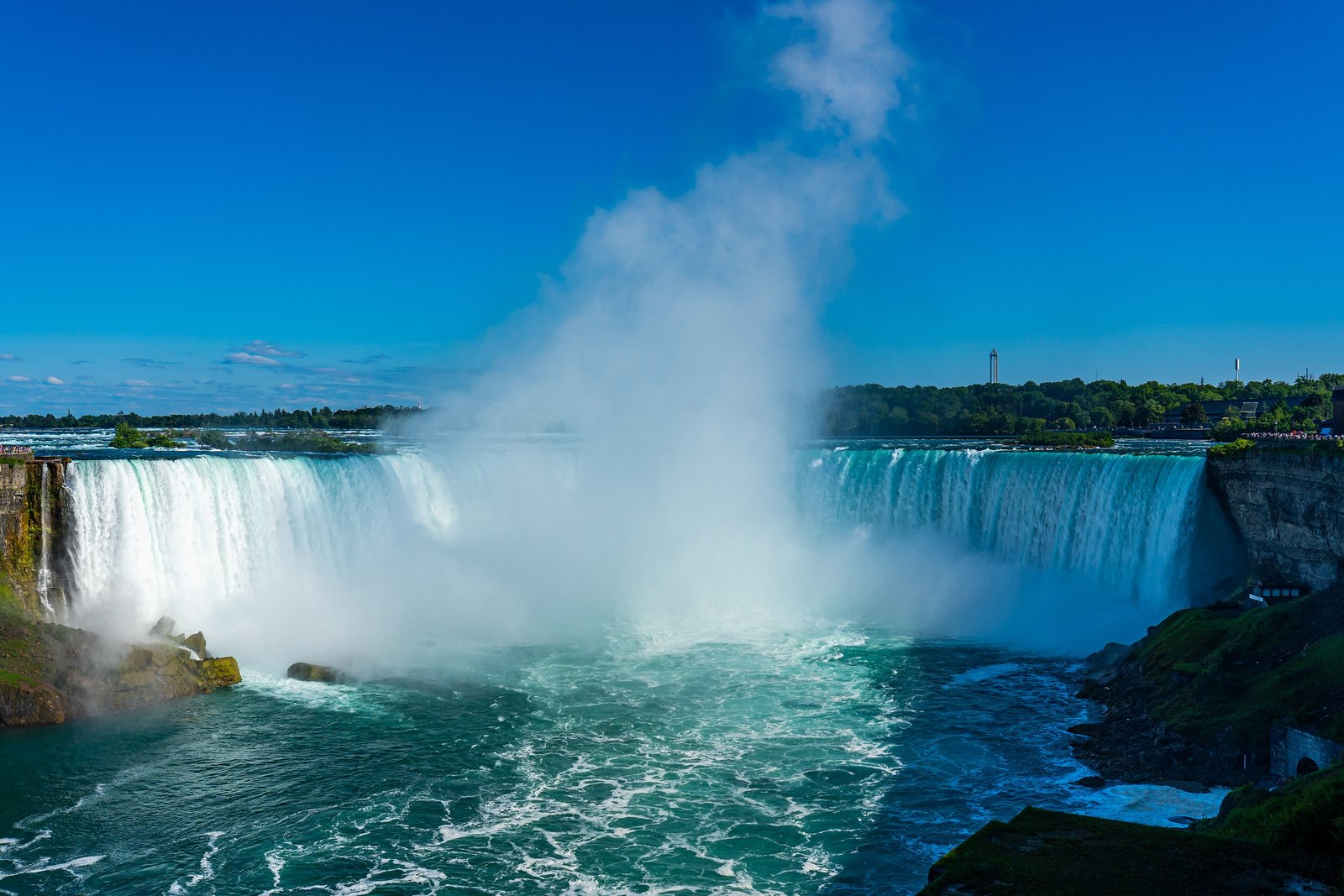
Niagara Falls is the name for three waterfalls on the Niagara River, which drains Lake Erie into Lake Ontario along the border between Ontario and New York. The Horseshoe Falls, the largest, is on the Canadian side; the American Falls and the smaller Bridal Veil Falls are on the United States side, separated by Goat Island and Luna Island. Wikipedia gives the Horseshoe Falls as about 57 metres high and 790 metres wide, and the American Falls as 21 to 30 metres high, depending on the boulders at its foot. The flow over all three is set by the 1950 Niagara Treaty between Canada and the United States, and the rest of the river is diverted to hydroelectric stations on both sides. New York created the Niagara Reservation in 1885, and Ontario the Queen Victoria Niagara Falls Park the same year.
Why it's worth knowing
The falls a visitor sees are the result of a timetable.
The Niagara Treaty, signed on 27 February 1950, requires, in the words the International Joint Commission quotes, that the flow over the falls be not less than 100,000 cubic feet per second (2,832 m³/s) between 8 a.m. and 10 p.m. Eastern Standard Time from 1 April to 15 September, and between 8 a.m. and 8 p.m. from 16 September to 31 October. At all other times, at night and through the winter months, the minimum is 50,000 cubic feet per second. Water above those minimums and other priority uses is divided equally between the two countries for power.
So the falls run at a daytime setting in the tourist season and a lower one after dark. Ontario Power Generation and the New York Power Authority draw their share from the pool above the falls, through tunnels, an open canal and covered conduits, to power stations downstream. Representatives of the International Niagara Committee, set up under the treaty, check compliance with weekly inspections on site, and the International Niagara Board of Control reports to the International Joint Commission. The volume of one of the most famous waterfalls on Earth is, within limits, a decision.
The tool that carries out the decision stands in the river. The International Niagara Control Works, a line of eighteen sluice gates about 0.8 kilometres above the Horseshoe Falls, reaches from the Canadian shore a little over halfway across. By the Commission’s account it keeps enough water going over the falls, holds the pool above at the level that governs how much can be diverted, and is used to flush ice and to help in emergencies.
The field notes
The summer the American Falls stopped
In June 1969 a temporary dam of rock and earth was built across the head of the American Rapids, and the American Falls went dry. Wikipedia and Niagara Falls State Park give the same outline: for several months geologists and engineers from the U.S. Army Corps of Engineers studied the exposed rock face, and faults that would have hastened the collapse of the crest were bolted and strengthened. A plan to clear the huge pile of fallen rock at the foot of the American Falls was abandoned as too costly, and nature was left to take its course. The dam was removed in November 1969 and the water came back.
The falls have stopped on their own once. Wikipedia records an ice jam on 29 March 1848 that cut the flow over all of them to nothing, or a trickle, for as much as 40 hours; mills that ran on the river stopped with it.
A waterfall that walks upstream
The falls have not always been here. About 10,900 years ago, Wikipedia’s account says, they stood near the escarpment between present-day Queenston, Ontario, and Lewiston, New York, and erosion of the crest has moved them about 10.9 kilometres upstream since, cutting the Niagara Gorge as they went. Engineering has slowed it: underwater weirs turn the most damaging currents and the crest has been strengthened, and Wikipedia puts the present rate of erosion at about 30 centimetres a year, against a historical average of 1 to 1.5 metres.
Two parks, one waterfall
In the 1870s, Wikipedia records, sightseers had little public access to the falls and often had to pay for a glimpse, and the Free Niagara movement, with the painter Frederic Edwin Church and the landscape designer Frederick Law Olmsted among its leaders, pressed for public land. Preservationists won their case on 30 April 1885, when New York created the Niagara Reservation, the state’s first state park; Ontario established the Queen Victoria Niagara Falls Park the same year. After dark, floodlights on the Canadian side light both falls in colour for several hours.
Where the name comes from is disputed. Wikipedia sets out several derivations, among them George R. Stewart’s from an Iroquoian town name, and the Iroquoian scholar Bruce Trigger’s from a branch of the Neutral Confederacy who lived here, shown on late seventeenth-century French maps.
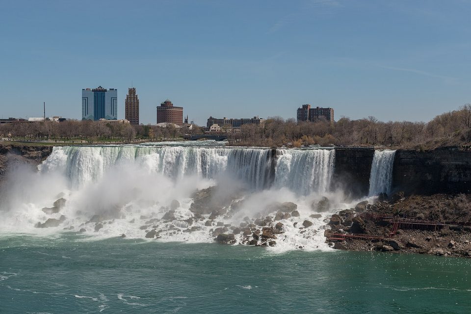
The American Falls and the Bridal Veil Falls, looking west from the Canadian side, April 2017.
Photograph: DXR · CC BY-SA 4.0 · cropped
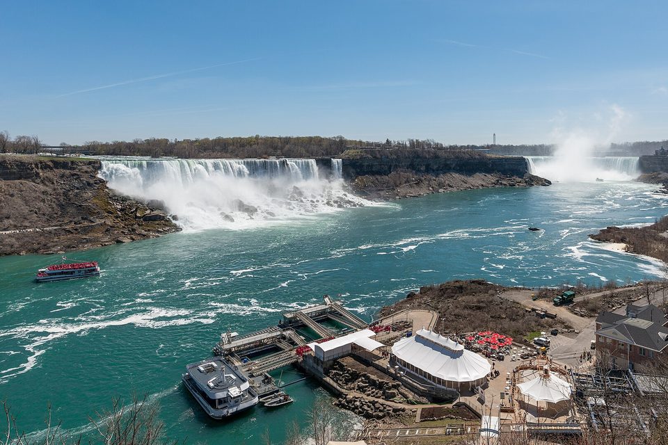
Looking up the gorge to the American Falls and Horseshoe Falls, with the boat landing on the Canadian shore below, April 2017.
Photograph: DXR · CC BY-SA 4.0 · cropped
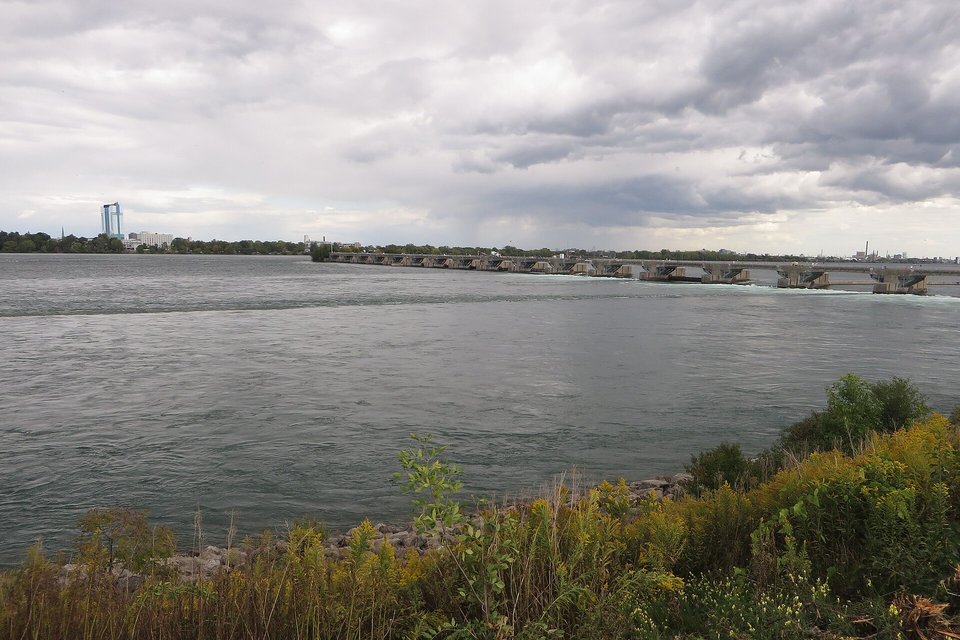
The International Niagara Control Works, the gated weir that sets how much water reaches the falls, from the Ontario shore, September 2016.
Photograph: Ken Lund · International Control Dam, Niagara Falls, Ontario (29951190116) · CC BY-SA 2.0 · cropped
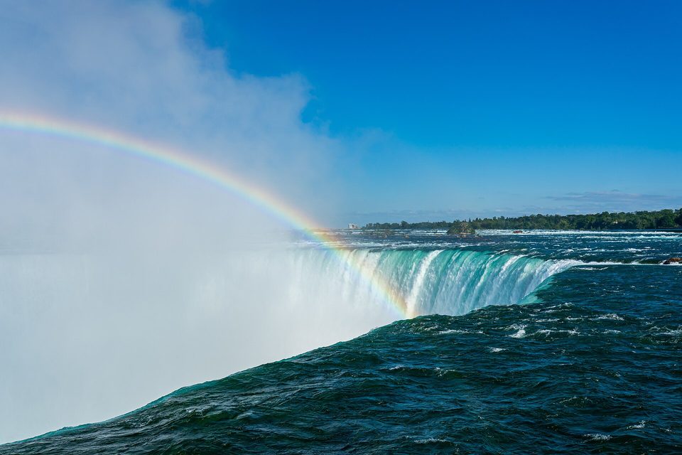
A rainbow over the lip of Horseshoe Falls, June 2021.
Photograph: Maksim Sokolov (maxergon.com) · CC BY-SA 4.0 · cropped
- Come once by day and once after dark, and see whether you can tell the difference.
- Take the plastic cape they hand you, and do not bother about your hair.
- Walk upstream above the edge, where the river is still deciding.
- Carry your papers. Half the view is in the other country.
- See it from both sides. (Saw it from one side. Crossed. Remembered something on the first side. Crossed back. Item retained in both countries.)
The International Niagara Control Works. A row of eighteen sluice gates set across the upper Niagara River about 0.8 kilometres above the Horseshoe Falls, reaching from the Canadian shore a little over halfway across. The International Joint Commission describes what it is for: making sure enough water goes over the falls, setting the level of the pool the power stations draw from, and moving ice. It is concrete and steel, it is not on anyone’s postcard, and every day it helps decide how much waterfall there is.
Tally, in the marginA row of gates halfway across the river, deciding how much waterfall there is today. I stood above them for a long time admiring the rapids before I noticed they were being told what to do.
Getting there
How to get there. Two cities share the falls: Niagara Falls, Ontario, and Niagara Falls, New York, joined by the Rainbow Bridge. The nearest large airports are Buffalo on the American side and Toronto on the Canadian side. The best views of the Horseshoe Falls are from the Canadian bank; the American side gives Goat Island, Luna Island and the rapids from close quarters.
Crossing between the sides. Walking or driving from one side to the other is an international border crossing. Carry a passport or another document accepted by both countries, and check the entry rules for your nationality before you go.
When to go. The treaty is a practical guide: the full daytime minimum applies from 8 a.m. to 10 p.m. Eastern Standard Time between 1 April and 15 September, and to 8 p.m. until 31 October. At night and from November to March the minimum halves. Boat trips into the spray below the falls run from both sides in the warm months. Winter brings ice formations and fewer people, but the falls rarely stop.
What costs money. The riverside parks and viewpoints on both sides are free to walk; the boats, the tunnels and the attractions charge. Check the parks’ own sites for current prices.
Mark this place
Common questions
How much water goes over Niagara Falls?
Under the 1950 Niagara Treaty between Canada and the United States, at least 100,000 cubic feet per second (2,832 m³/s) must go over Niagara Falls from 8 a.m. to 10 p.m. EST between 1 April and 15 September, and from 8 a.m. to 8 p.m. between 16 September and 31 October. At all other times the minimum is 50,000 cubic feet per second. The International Joint Commission publishes the terms.
Why is Niagara Falls lower at night?
Because the 1950 Niagara Treaty lets Canada and the United States divert more of the Niagara River to hydroelectric power at night and in winter. The treaty minimum over Niagara Falls is 100,000 cubic feet per second by day in the tourist season and 50,000 at other times; water above the minimums is shared equally between Ontario Power Generation and the New York Power Authority.
What controls the flow over Niagara Falls?
The International Niagara Control Works, a line of eighteen sluice gates about 0.8 kilometres upstream of the Horseshoe Falls, reaching from the Canadian shore a little over halfway across the Niagara River. According to the International Joint Commission it ensures enough water goes over Niagara Falls, holds the level of the pool from which the power stations draw, and is used to flush ice.
When was the American Falls turned off?
In June 1969 a temporary rock-and-earth dam diverted the Niagara River away from the American Falls so that the U.S. Army Corps of Engineers could study the dry rock face. Faults in the crest were bolted and strengthened, a plan to remove the fallen rock at the base was dropped as too costly, and the dam was removed in November 1969.
Has Niagara Falls ever frozen or stopped?
Niagara Falls stopped once on its own. Wikipedia records that an ice jam on 29 March 1848 cut the flow over the falls to nothing or a trickle for up to 40 hours, stopping the mills that depended on it. In 1912 the American Falls froze while the Horseshoe Falls kept flowing. The falls ice up in most winters but keep running.
Which side of Niagara Falls is better, Canadian or American?
The Horseshoe Falls, the largest of the three Niagara Falls, is on the Canadian side, and the Ontario bank gives the widest views of it. The New York side has Goat Island, Luna Island and close views of the American Falls and the rapids. Crossing between them over the Rainbow Bridge is an international border crossing that needs a passport or equivalent document.
How tall is Niagara Falls?
Wikipedia gives the Horseshoe Falls, the largest of the Niagara Falls, as about 57 metres high and 790 metres wide, and the American Falls as 21 to 30 metres high, the drop varying because of the boulders piled at its base. The Bridal Veil Falls, beside the American Falls, is separated from it by Luna Island.
Is Niagara Falls moving?
Yes. About 10,900 years ago Niagara Falls stood near the escarpment between Queenston, Ontario, and Lewiston, New York, and erosion of the crest has moved it about 10.9 kilometres upstream since, cutting the Niagara Gorge, according to Wikipedia. Engineering works have slowed the retreat to about 30 centimetres a year.