
Part of The US National Parks
- Where
- Grand County, eastern Utah
about 6 km north of Moab - Coordinates
- 38.7281° N
109.5400° W - Arches
- More than 2,000
(National Park Service) - Protected
- National monument 1929
national park 1971 - Delicate Arch trail
- 4.8 km return, 164 m climb
no shade (National Park Service) - Entry in 2026
- No timed-entry reservation
(National Park Service) - Latest major fall
- Wall Arch
night of 4 August 2008
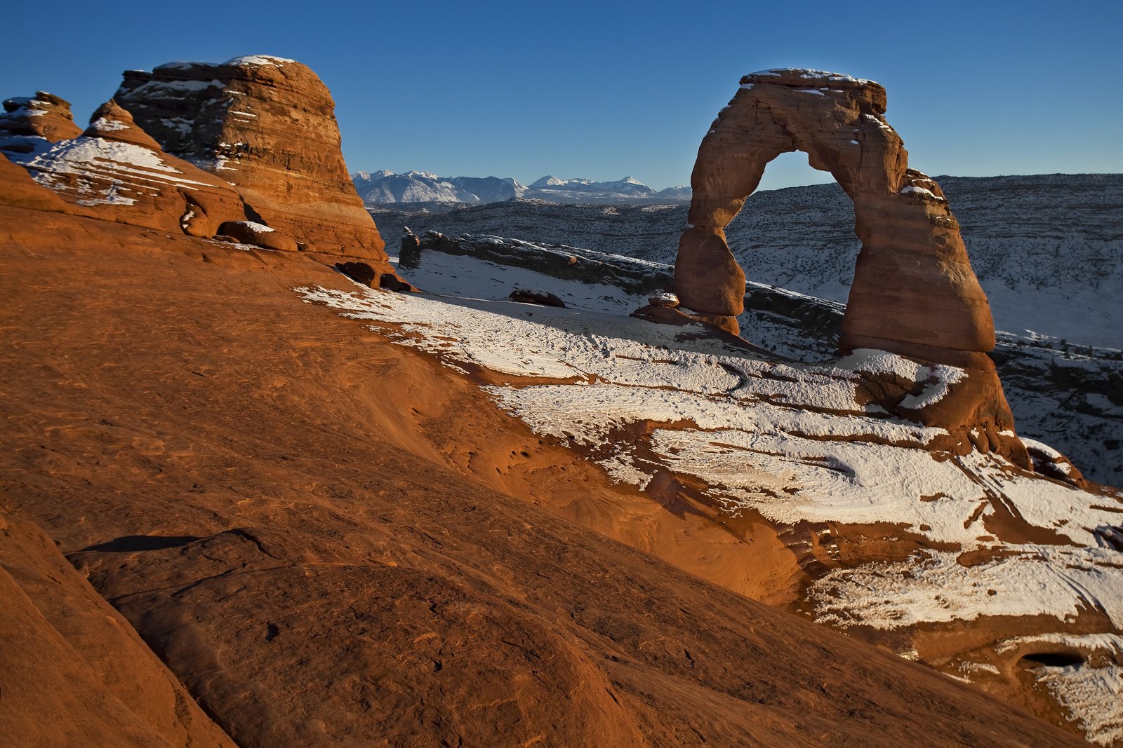
Climbed a long bare slope of red rock in the late heat, then edged round a ledge, and there it was on the lip of a bowl: a span of stone standing up by itself, a white-topped range far off behind it. People took turns to stand underneath, one at a time. When my turn came I held my breath and tried to weigh nothing.
The short answer
Arches National Park covers about 310 km² of high desert on the Colorado Plateau in eastern Utah, beside the Colorado River and about 6 km north of the town of Moab. The National Park Service counts more than 2,000 natural sandstone arches there, which it calls the greatest concentration of rock arches in the world, among fins, balanced rocks and spires. The best known is Delicate Arch, a free-standing span at the rim of a bowl of bare rock. The area became a national monument in 1929 and a national park in 1971, and by Wikipedia’s account it receives less than 250 mm of rain a year.
Why it's worth knowing
The arches are made by salt. The Park Service’s geology pages explain that a thick bed of salt and gypsum, the Paradox Formation, lies deep beneath the park. Salt flows under pressure, and it pushed the rock above it up into long ridges; as groundwater dissolved the salt, the ridges sagged and cracked along closely spaced parallel joints. In the Entrada Sandstone the rock between the cracks weathered into fins, and where a fin lost a section from its middle and kept its top, an arch was left.
And the arches fall. On the night of 4 August 2008 Wall Arch, which spanned a 71-foot (22-metre) gap in Devils Garden, collapsed; nobody saw it, but campers reported hearing a loud rumbling, the Park Service records. In 1991 visitors heard cracking and caught on video a large slab dropping from the underside of Landscape Arch, which the Natural Arch and Bridge Society ranks as the fifth-longest arch in the world, with a span of about 88 metres; two more rockfalls followed in 1995, and the trail beneath it has been closed since. The Park Service’s view is calm: rain, ice and groundwater slowly dissolve the natural cement that holds the sand grains together, and new arches are forming at a similar pace.
The Service once considered holding back the clock. Wikipedia, citing John F. Hoffman’s guide to the park, records that in the 1950s it investigated coating Delicate Arch in clear plastic to protect it from erosion, and dropped the idea as impractical and contrary to its principles. After a climber made free-solo ascents of Delicate Arch in May 2006, by Wikipedia’s account, the park banned climbing on any named arch.
The field notes
The chaps, the bloomers and the licence plate
Before it was Delicate Arch, local cowboys had their own names for it: the Park Service records the Cowboy’s Chaps and the Old Maid’s Bloomers, and the plainer Salt Wash Arch. Wikipedia credits its present name to Frank Beckwith, who led a scientific expedition to the national monument in the winter of 1933–34; the arch was outside the monument until it was enlarged in 1938. It is on Utah’s licence plates, and the torch relay for the 2002 Winter Olympics passed through it.
Wolfe Ranch and the riders on the rock
The Delicate Arch trail starts at Wolfe Ranch, where, by the Park Service’s account, John Wesley Wolfe and his eldest son Fred settled beside Salt Wash near a freshwater spring. Near the ranch a panel of petroglyphs shows bighorn sheep and riders on horseback, which the Park Service attributes to the Ute; it notes that Zuni, Hopi, Ute, Paiute and many other peoples travelled through these landscapes.
The ground is alive
Between the rocks, much of the dark, lumpy soil is a living crust of cyanobacteria, algae, fungi and lichens. Wikipedia’s account says it is one of the things that make the park so fragile under more than a million visitors a year; a footprint breaks it. Staying on bare rock and marked trails protects it.
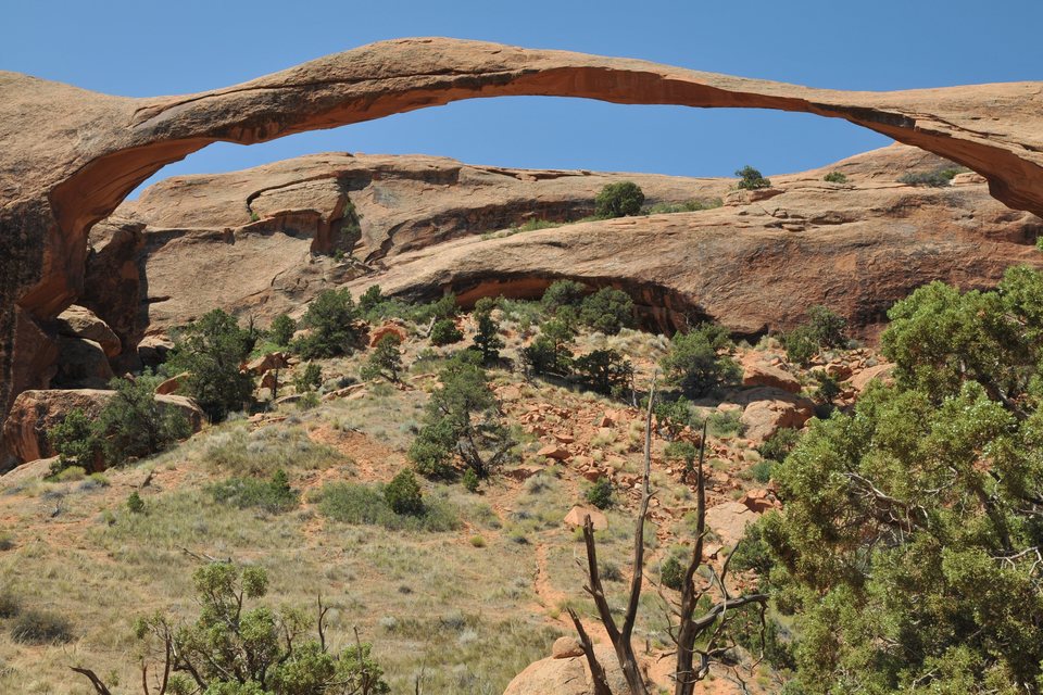
Landscape Arch in Devils Garden, a ribbon of sandstone about 88 m across, August 2008.
Photograph: Woluwebe · Landscape Arch · CC BY-SA 3.0 · cropped
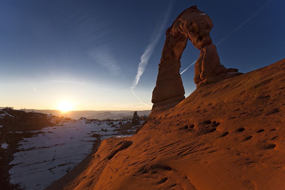
Delicate Arch from the south in January, when the sandstone glows and the ledge trail can ice over.
Photograph: Jacob W. Frank, National Park Service · Public domain
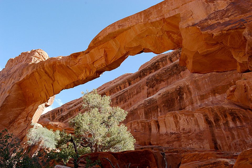
Wall Arch in 2003, five years before it fell unseen on the night of 4 August 2008.
Photograph: G. Edward Johnson · Wall arch before collapse 20030917 094903 1 · CC BY 3.0 · cropped
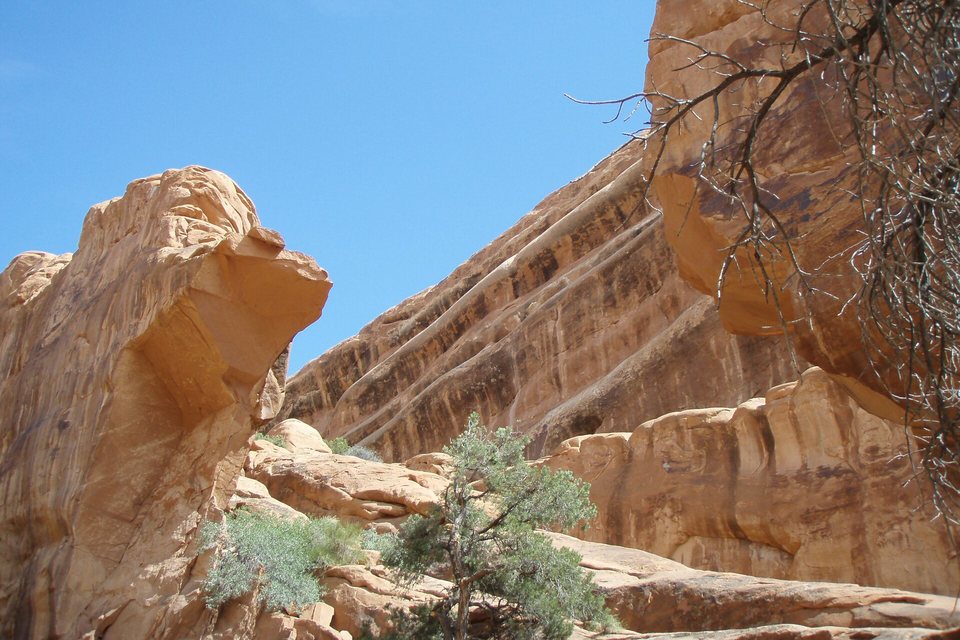
Wall Arch the morning after it fell, 5 August 2008: a gap of open sky where the span stood.
Photograph: Neal Herbert, National Park Service · Public domain · cropped
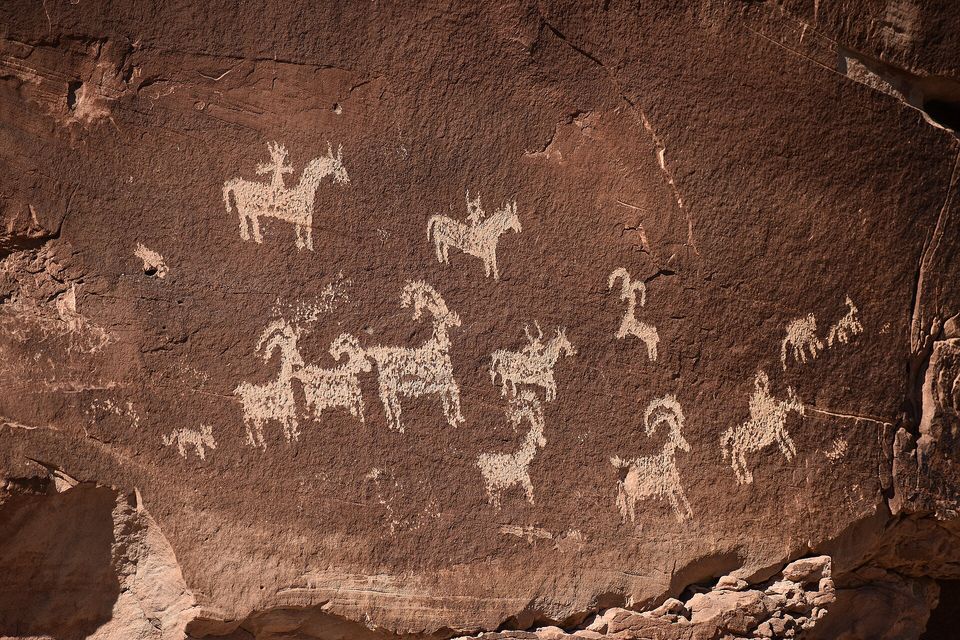
Ute petroglyphs near Wolfe Ranch: riders on horseback among bighorn sheep, pecked into the rock face.
Photograph: Marty Tow, National Park Service · Public domain
- Start the climb in the cool of early morning or late in the day, never at noon.
- Stop at the riders pecked into the rock near the start, and leave them exactly as their makers did: no fingers.
- Carry nothing up the slope but water, and more of it than seems sensible. (Left the list in the car, to save weight, and wrote the new items on the back of my hand. They wore off faster than any arch.)
- Keep to bare rock and the trail. The dark, lumpy crust between is alive, and slow to mend.
- Walk out to a place where one has fallen, and pay your respects to the pile.
Delicate Arch. A free-standing span of reddish Entrada Sandstone at the lip of a bowl of bare rock, with the La Sal Mountains behind it, at the end of a long climb up open slickrock. Local cowboys called it the Cowboy’s Chaps and the Old Maid’s Bloomers before a scientific expedition gave it its present name, and it is on the state’s licence plates. The Park Service once looked into coating it in clear plastic against the weather, and decided not to. It is being worn away grain by grain like every other arch in the park, and nobody knows when it will go.
Tally, in the marginA clear raincoat, for an arch. I am glad they left it out in the weather with the rest of us, and I only wish I had known before my turn underneath, because I would have said something kind.
Getting there
How to get there. The park entrance is on US Highway 191, about 6 km (4 miles) north of Moab, and Interstate 70 passes about 32 km to the north, by the Park Service’s account.
What to book ahead. The Park Service announced that Arches would not require timed-entry reservations in 2026: visitors may enter at any time during operating hours, though entrance lines and full car parks are likely at busy times, and an entrance pass is still needed, from Recreation.gov or at the gate. Reservations are still required for the Devils Garden Campground and for Fiery Furnace hikes. Arches is not among the eleven parks charging the $100 non-resident fee introduced in 2026.
When to go, and the heat. The Delicate Arch trail is a strenuous 4.8 km (3 mile) return climb of 164 m (538 ft) up bare slickrock with no shade, and just before the arch it follows a narrow rock ledge for about 180 metres that is often icy in winter. The Park Service advises avoiding the hike in the midday summer heat, carrying at least 2 litres of water per person, because there is none at the trailhead, and taking a headlamp for a sunset visit.
Safety. The State Department’s travel advisories cover other countries, so none applies here; the hazards are the desert’s own, above all heat and exposure on the trails.
Mark this place
Common questions
How many arches are in Arches National Park?
The National Park Service counts more than 2,000 natural sandstone arches in Arches National Park, in eastern Utah, which it describes as the greatest concentration of rock arches in the world. The best known is Delicate Arch.
How were the arches in Arches National Park formed?
According to the National Park Service, a thick bed of salt and gypsum lies deep beneath Arches National Park. It pushed the rock above it into ridges, which cracked along parallel joints as groundwater dissolved the salt. The Entrada Sandstone between the cracks weathered into fins, and arches formed where fins lost their middles and kept their tops.
Do the arches in Arches National Park fall down?
Yes. Wall Arch in Arches National Park collapsed on the night of 4 August 2008, unseen, and a large slab fell from Landscape Arch in 1991, with more rockfalls in 1995. The National Park Service says erosion slowly dissolves the cement holding the sandstone together, and that new arches are forming at a similar pace.
How long is the hike to Delicate Arch?
The National Park Service describes the Delicate Arch trail as a strenuous 3-mile (4.8 km) round trip climbing 538 feet (164 m) up slickrock with no shade, ending on a narrow ledge about 200 yards long. It advises bringing at least 2 litres of water per person and avoiding the hike in the midday summer heat.
Do you need a reservation for Arches National Park in 2026?
No. The National Park Service announced that Arches National Park would not require timed-entry reservations in 2026, so visitors can enter at any time during operating hours with a valid entrance pass. Reservations are still needed for the Devils Garden Campground and Fiery Furnace hikes.
What was Delicate Arch called before?
Local cowboys called Delicate Arch the Cowboy’s Chaps and the Old Maid’s Bloomers, and it was also known as Salt Wash Arch, according to the National Park Service. Wikipedia credits its present name to Frank Beckwith, who led a scientific expedition to the national monument in 1933–34.
Is it safe to hike to Delicate Arch in summer?
The Delicate Arch trail has no shade and no water at the trailhead, and the National Park Service advises avoiding it in the midday summer heat. Hike early in the morning or late in the day, carry at least 2 litres of water per person, and take a headlamp if you stay for sunset.
Can you climb the arches in Arches National Park?
No. By Wikipedia’s account, Arches National Park prohibits climbing on any named arch year-round, a rule tightened after a climber made free-solo ascents of Delicate Arch in May 2006. Slacklining is also banned.