
- Where
- South-eastern Pacific
about 3,700 km west of mainland Chile - Coordinates
- 27.1127° S
109.3497° W - Moai
- 887 extant (Wikipedia)
962 in Lipo and Hunt’s 2025 study - Quarry
- Rano Raraku
(about 95% of moai) - Park
- UNESCO 1996
run by Ma’u Henua since 2017 - Visits
- Sites with an accredited guide
stays of up to 30 days - Advisory
- Chile Level 2
Grass, wind and a sea with nothing on the other side of it. Round green hills with hollows in their tops, one of them holding a lake of reeds. A row of great stone figures with their backs to the water, looking inland as if keeping an eye on the family. Our guide named them, and I said how do you do to each, and meant it every time.
The short answer
Easter Island, Rapa Nui in its own language and Isla de Pascua in Spanish, is a volcanic island of about 164 square kilometres in the south-eastern Pacific, about 3,700 km west of mainland Chile and, by Wikipedia’s account, one of the most remote inhabited islands in the world. Polynesian voyagers settled it at some point between 300 and 1200 CE, Wikipedia says; the Dutch explorer Jacob Roggeveen, who arrived on Easter Sunday 1722, gave it its European name, and Chile annexed it in 1888. Its people carved the moai, monolithic human figures, mostly between 1250 and 1500, about 95 per cent of them from the volcanic tuff of the Rano Raraku crater. Archaeologists read them as representations of ancestors. Those on the platforms, the ahu, face inland towards the villages, except the seven at Ahu Akivi, which face the sea. Much of the island is Rapa Nui National Park, a UNESCO World Heritage Site since 22 March 1996, and since 2017 the park has been administered by the Ma’u Henua Polynesian Indigenous Community.
Why it's worth knowing
For as long as outsiders have visited, they have asked how the Rapa Nui moved stone figures weighing many tonnes across the island. Their answers have included wooden sledges, rollers and prepared tracks. The Rapa Nui had their own answer. Oral histories recorded on the island, Wikipedia’s account says, tell that the statues walked: in the earliest, a king named Tuu Ku Ihu moved them with the help of the god Makemake; in later ones, a woman living alone on the mountain commanded them.
In 1986 Pavel Pavel, with Thor Heyerdahl and the Kon-Tiki Museum, rocked two moai forward with ropes, but stopped because the bases were chipping. Working with the Rapa Nui archaeologist Sergio Rapu, the archaeologists Terry Hunt, now of the University of Arizona, and Carl Lipo, now of Binghamton University, took the idea further. They studied the statues left lying along the island’s ancient roads and argued that these “road moai” had wide, D-shaped bases and a forward lean that let them be rocked from side to side and “walked” upright by teams pulling ropes from both sides, a case first made in the Journal of Archaeological Science in 2013, with a replica walked on the island.
In 2025 they set out the full case in the same journal. By Binghamton University’s account of the paper, they analysed 962 moai with a focus on 62 road statues, modelled them in three dimensions, and walked a 4.35-ton replica with the same forward lean 100 metres in 40 minutes with a team of 18. They also describe the roads as about 4.5 metres wide and concave in section, which they count among the evidence. Not everyone is persuaded: Wikipedia records that the debate continues, and Jo Anne Van Tilburg’s team moved a replica on a sledge over rollers in 1999. The stories said walked; the experiment gave the word a mechanism.
The field notes
The quarry
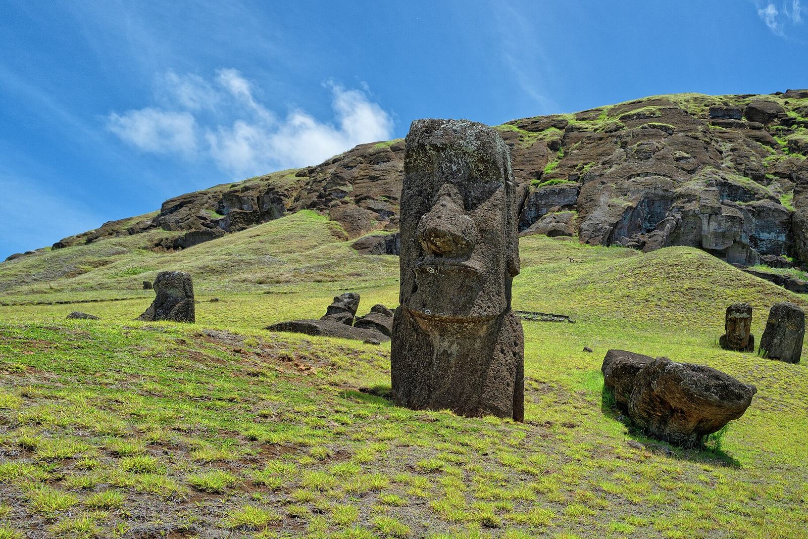
Rano Raraku, a crater of consolidated volcanic ash on the south-east of the island, was the moai quarry for about 500 years until the early eighteenth century, Wikipedia says. Hundreds of statues remain there, some still attached to the rock and some standing on the outer slopes, buried to their shoulders in quarry debris, which is why so many photographs show only heads and why the moai are so often thought of as heads. The largest unfinished figure, at 21.6 metres, is almost twice the height of any moai ever completed. A freshwater lake lies inside the crater, ringed with reeds. Across the island, on its south-western headland, the crater of Rano Kau, almost a mile across, holds one of the island’s only three natural bodies of fresh water, by Wikipedia’s account, and Orongo, the ceremonial village of the birdman contest, stands on its rim. In October 2022 a fire swept the area and, by Wikipedia’s account, left damage to some statues that authorities described as irreparable.
Fifteen on one platform
Ahu Tongariki, about a kilometre from the quarry, is the largest platform on the island, with fifteen moai. Wikipedia’s account says its statues were toppled in the island’s past conflicts and that in 1960 a tsunami set off by an earthquake off the coast of Chile swept the platform inland. It was restored in the 1990s by a team led by the archaeologists Claudio Cristino and Patricia Vargas, under an agreement between the Chilean government, the University of Chile and the Japanese crane maker Tadano. One of its moai, at 86 tonnes, is the heaviest ever raised on the island.
What the nineteenth century took
In December 1862 Peruvian slave raiders reached the island and, over several months, took about 1,500 people, half the population, among them the paramount chief and those who could read the rongorongo script, Wikipedia records. Survivors sent home carried smallpox, and epidemics and departures followed; by 1877 only 111 people lived on the island. For much of the twentieth century the Rapa Nui were confined to the town of Hanga Roa while the rest of the island was leased as a sheep ranch. Wikipedia describes the handing of the national park to the Ma’u Henua community in 2017 as the return of ancestral lands.
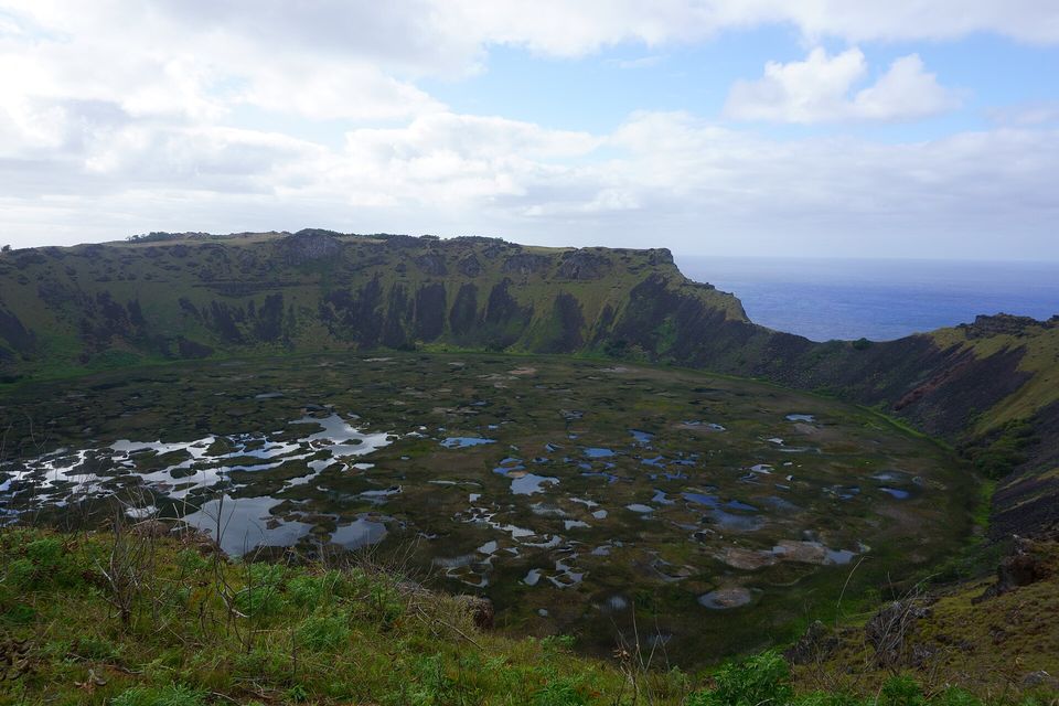
The crater of Rano Kau, a volcano on Rapa Nui, its floor a mat of reeds and open water, seen from the rim, September 2018.
Photograph: Kallerna · CC BY-SA 4.0
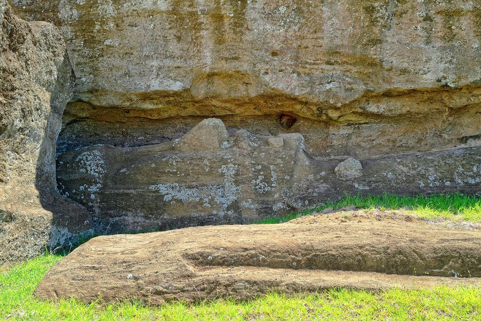
An unfinished moai still lying in the bedrock at Rano Raraku, where it was being carved, February 2024.
Photograph: Otávio Nogueira · Fabrica de Moais-10 · CC BY 2.0
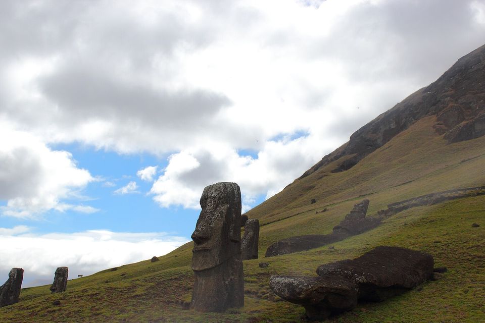
Moai on the outer slope of Rano Raraku, one standing tall and others lying where they came to rest, September 2012, before the 2022 fire.
Photograph: Mbmerino · Moais in Rano Raraku. Easter Island · CC BY-SA 3.0 · cropped
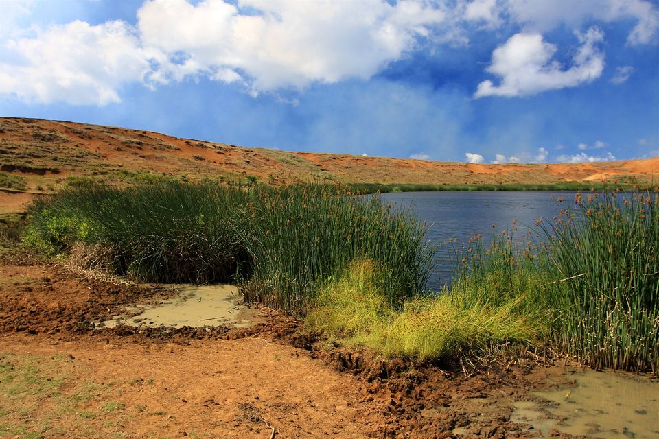
Totora reeds around the freshwater lake inside the Rano Raraku crater, December 2010, before the 2022 fire.
Photograph: TravelingOtter · Crater Lake at Rano Raraku - Easter Island · CC BY 2.0
- Keep the guide in front of you all day. The figures are family here, and it is for the family to do the talking.
- Write down the name of every figure you meet. I managed one, and then the guide’s name three different ways, until she kindly spelled it for me.
- Keep off the platforms and touch nothing carved, however friendly it looks.
- Go to the quarry and walk the path past the ones still lying in the hillside, half made.
- Come for the summer festival if you can, and cheer from the edge.
A totora reed, of the kind that rings the freshwater lake inside the old quarry crater at Rano Raraku, among the half-carved figures. The Rapa Nui used them for thatch and to help them swim: in the birdman contest, the men who swam out to the islet of Motu Nui for the season’s first sooty tern egg carried their food in a bundle of reeds called a pora. Thor Heyerdahl counted the reeds among plants that he said had come from South America with people. The pollen in the crater mud says they were growing here tens of thousands of years before anybody came.
Tally, in the marginA reed that visitors kept explaining, when all it was ever doing was growing. There is a lesson in that for anybody carrying a notebook, and I am the one carrying the notebook.
Getting there
How to get there. The only way in is by air, to Mataveri International Airport beside the town of Hanga Roa: Chile Travel gives the direct flight from Santiago as five and a half hours, and recommends booking flights and lodging months ahead. Chile’s government requires visitors to fill in an entry form, hold a return ticket and show a hotel reservation or an invitation from a resident, and limits a tourist’s stay to 30 days, a law in force since August 2018.
In the park. The national park ticket is bought online in advance, with no sales at the sites; Chile Travel gives it as US$80 for foreign visitors, valid for ten days from the first site entered. To visit archaeological sites such as Rano Raraku and Orongo you must be accompanied by an accredited local guide, and the same applies across the park’s archaeological sites; the guide is part of the visit, not an extra. Never touch or climb the moai or walk on the platforms: in 2008 a visitor who chipped a piece off a moai’s ear was fined and banned from the island for three years, by Wikipedia’s account.
When to go. The island is visited all year. Chile Travel recommends February for the Tapati festival, when Rapa Nui culture is celebrated across the island.
Safety. The State Department has Chile at Level 2, exercise increased caution, for crime and for demonstrations in Santiago and other cities, with no area-specific warnings; nothing in it concerns the island. The advisory also carries a Centers for Disease Control Level 1 notice for Andes virus in the region, which it says poses an extremely low risk to most travellers.
Mark this place
Common questions
How did the Easter Island statues move?
Rapa Nui oral histories say the moai walked to their platforms. In papers in the Journal of Archaeological Science in 2013 and 2025, archaeologists Carl Lipo and Terry Hunt argued that many were moved upright, rocked from side to side with ropes, and walked a replica 100 metres in 40 minutes with 18 people. Other archaeologists have tested sledges, and the debate continues.
How many moai are there on Easter Island?
Wikipedia gives 887 extant moai on Easter Island (Rapa Nui), nearly half of them still at the Rano Raraku quarry. Carl Lipo and Terry Hunt’s 2025 study in the Journal of Archaeological Science analysed 962 moai; the two figures come from different inventories.
Do you need a guide on Easter Island?
Yes, for the archaeological sites. Chile Travel says visitors to sites in Rapa Nui National Park, such as Rano Raraku and Orongo, must be accompanied by an accredited local guide. The park ticket is bought online in advance and is valid for ten days from the first site visited.
Who manages Rapa Nui National Park?
Since 2017 Rapa Nui National Park on Easter Island has been administered by the Ma’u Henua Polynesian Indigenous Community, after the Chilean government returned its management to the Rapa Nui people. Chile’s forestry agency, CONAF, ran it from 1972 to 2015. UNESCO inscribed the park as a World Heritage Site in 1996.
Why do the moai face inland?
Archaeologists read the moai of Easter Island as representations of ancestors, and those on the ahu platforms face inland towards the villages, as if watching over the people, by Wikipedia’s account. The exception is the seven moai of Ahu Akivi, which face the sea.
How do you get to Easter Island?
Easter Island (Rapa Nui) is reached only by air, on direct flights from Santiago, Chile, to Mataveri International Airport beside Hanga Roa; Chile Travel gives the flight as five and a half hours. Chile requires an entry form, a return ticket and proof of lodging, and limits tourist stays to 30 days.
Where does the name Easter Island come from?
The Dutch explorer Jacob Roggeveen named it Easter Island after arriving on Easter Sunday 1722; its Spanish name, Isla de Pascua, means the same. The name Rapa Nui was given in the nineteenth century, according to Wikipedia, by a Tahitian visitor who thought it resembled the island of Rapa, but bigger.
What happened to the people of Easter Island in the nineteenth century?
In December 1862 Peruvian slave raiders abducted about 1,500 people from Easter Island, half its population, and smallpox brought back by survivors caused devastating epidemics. With further deaths and departures, only 111 people lived on the island by 1877, according to Wikipedia. The population has since recovered.