
- Where
- Off Temwen Island, Madolenihmw
eastern Pohnpei, Micronesia - Coordinates
- 6.8397° N
158.3308° E - Biome
- Reef flat, mangrove channel,
coastal tropical forest - The islets
- 92 to over 100, by source
on 76.7–83 ha of reef - Built
- Monumental phase from AD 1180–1200
seat of the Saudeleur until c. 1628 - Status
- UNESCO World Heritage, 2016
and World Heritage in Danger - Best visited
- Year-round; go at high tide
for the canals
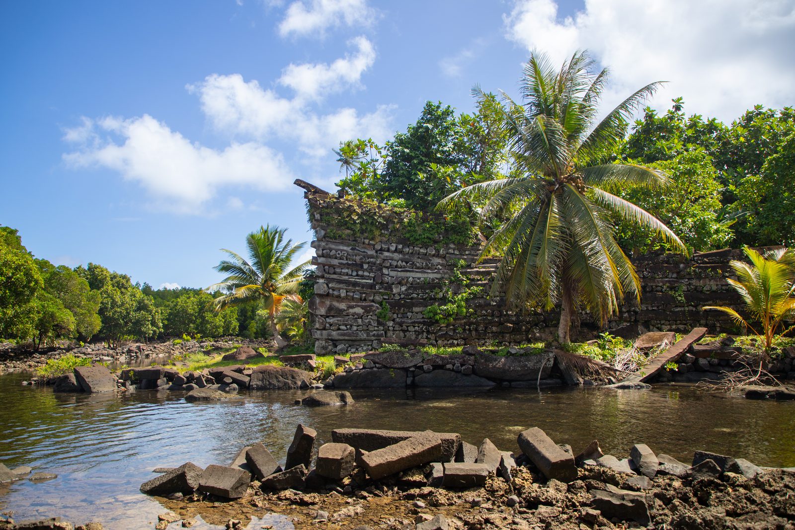
Came through mangrove mud on a narrow path and out among walls of black stone logs stacked criss-cross like an enormous woodpile, with the sea coming in between them along straight green channels. Coconut palms growing out of the tops. The corners lift at the ends, as if the whole place were about to put to sea. Nobody else there but a man at a house on the way in, who took a small fee and told me whose it is. I believed him.
The short answer
Nan Madol is a ruined ceremonial and administrative centre built on the shallow reef off Temwen Island, on the east coast of Pohnpei in the Federated States of Micronesia. It consists of artificial islets — platforms of coral rubble retained by walls of columnar basalt — separated by tidal canals: 92 in one count, 93 in another, and more than a hundred in UNESCO’s description. It was the seat of the Saudeleur dynasty, which ruled the whole of Pohnpei, and high-precision dating of coral from the tomb of the first Saudeleur shows monumental building under way by AD 1180–1200. UNESCO inscribed it in 2016 and placed it on the List of World Heritage in Danger in the same year. It is traditionally owned and protected by the Nahnmwarki, the paramount chief, of Madolenihmw.
Why it's worth knowing
Nan Madol is one of the places pseudo-archaeology loves best, and the reason is that it looks impossible. Walls of black stone logs, some several metres high, rising out of the sea at the edge of a small Pacific island, with no written record and no obvious way the stones got there.
So it has been handed, at one time or another, to almost everyone but the people who built it. James Churchward made it part of his lost continent of Mu in 1926, a claim with no scientific basis. Divers reported basalt pillars standing on the seabed offshore, and stories grew of drowned cities beneath the reef.
The pillars were investigated. In 1988 and 1989 a University of Oregon team found the prone basalt columns on the seafloor to be lost or discarded building stone, drove steel rods into the reported upright pillars, and found coral; one was raised and dissected and consisted entirely of coral. A 2013 survey with multibeam sonar and remotely operated vehicles found no evidence that any submerged column was man-made, and identified the nearby blue hole as a natural sinkhole.
What replaced the mystery is better than the mystery. Archaeologists have matched the basalt in the walls, by its chemistry, to particular quarries on Pohnpei, some on the far side of the island. They have dated coral packed into the first ruler’s tomb to within a couple of decades. And Pohnpei’s own tradition — of two brothers who came by canoe to build an altar, and of the tyranny that followed and was overthrown — describes a political centre in terms the archaeology increasingly fits.
The people of Pohnpei built Nan Madol. The evidence for that is now very precise, and the site does not need a lost continent to be astonishing.
The field notes
Nandauwas, the royal tomb
The largest and most elaborate islet is Nandauwas, in the mortuary sector of the site, built as the tomb of the first Saudeleur. It is roughly 80 by 60 metres, lifted more than a metre above the water on coral fill held in by basalt boulders and columns.
On it stand two enclosing walls, one inside the other. The outer wall is given as about eight metres high in places in the 2016 study, and as five and a half to seven and a half metres in other accounts. Both walls use the technique that defines Nan Madol: long hexagonal and pentagonal basalt columns laid in alternating directions, lengthways and endways, the pattern builders call header-and-stretcher, with coral rubble filling the core. The corners sweep upward, which is why the walls seem to lean out over the canals.
At the centre is the burial vault itself, roofed with more basalt columns laid across it.
Stone from the other side of the island
Columnar basalt forms when a thick lava flow cools and contracts into long prisms. Pohnpei has it in several places, of different geological ages, and each source has a slightly different chemical signature.
Mark McCoy and Stephen Athens, using portable X-ray fluorescence, reported in 2011 that the builders favoured columns from the island’s oldest volcanic stage, seven to eight million years old. A 2016 study led by McCoy went further: a volcanic plug called Pwisehn Malek, on the opposite side of Pohnpei, supplied an estimated forty per cent of the basalt in the central tomb’s walls and vault, and appears twice as often on Nandauwas as on the other islets tested. It was the costliest quarry on the island to use, and the authors read its use as a demonstration of the first rulers’ power over the whole island.
How the columns were moved is not established by the sources used here, and this entry does not guess.
Dated by the coral in a tomb
Radiocarbon dates from Pohnpei have long been untidy, and the 2016 study set out to do better. Instead of charcoal, it dated fresh branch coral that had been harvested live from the reef and packed into the tomb as building fill, using uranium-thorium dating, which can be very precise.
The results put the building of the central vault’s enclosing wall between AD 1172 and 1186, and the vault’s fill between 1197 and 1209: the tomb was in use by about 1180 to 1200. The authors describe this as the earliest secure evidence of monumental construction in the remote islands of the Pacific, followed over the next few centuries by monument building elsewhere in Oceania.
Earlier human activity on the same stretch of reef goes back much further, to the first or second century AD, and building of the islets began well before the great walls.
A capital that could not feed itself
There is no fresh water and no farmland on the islets. Everything the residents ate and drank was brought by canoe from Pohnpei, and the Saudeleur received their tribute at a particular islet set aside for it.
The population was small — almost certainly under a thousand, and perhaps under five hundred — and included many commoners as well as chiefs. One reading of the arrangement is political: by requiring rival chiefs to live at Nan Madol, the Saudeleur could keep them where they could be watched.
By Pohnpeian tradition the dynasty grew oppressive and was overthrown by Isokelekel, who is usually dated to around 1628 and who founded the line of Nahnmwarki that still exists. His successors lived at Nan Madol for a time and then left, perhaps because provisioning a city on a reef was more trouble than it was worth. UNESCO records that residential use had ended by the 1820s, though the site kept its religious and traditional importance.
Why it is in danger
Nan Madol went on UNESCO’s List of World Heritage in Danger in the same year it was inscribed, 2016, and it remains there.
The threat is slow and ordinary. The canals are silting up, which lets mangroves grow unchecked through the site; roots and trees are prising walls apart; storm surges have caused collapses. UNESCO’s statement says plainly that the condition of the stone structures is of extreme concern and that overgrowth hides many of them from view.
Work has been done — clearance, monitoring, and in 2018 support from the US Ambassador’s Fund for Cultural Preservation — under a management arrangement involving the national and state governments and the Nahnmwarki of Madolenihmw. A city built to last on a reef turns out to need the reef, and the canals, kept exactly as they were.
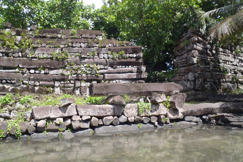
Header-and-stretcher: columns laid lengthways and endways.
Photograph: Patrick Nunn · CC BY-SA 4.0 · cropped
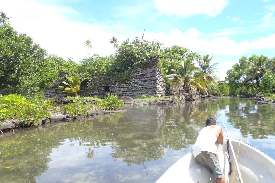
Arriving by canal at high tide.
Photograph: Patrick Nunn · CC BY-SA 4.0 · cropped
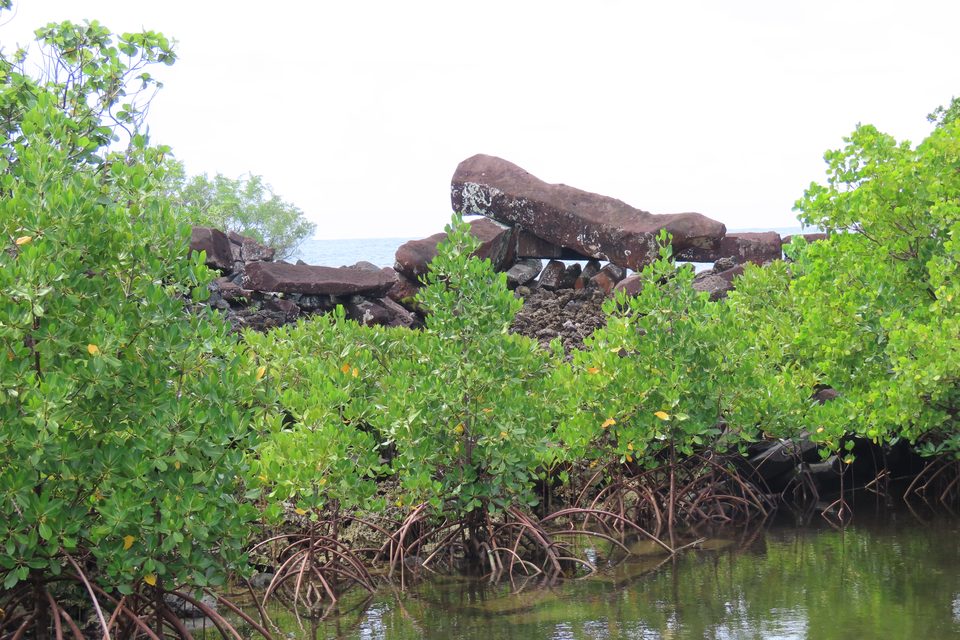
Mangrove growing through the ruins, the threat that put the site on UNESCO's in-Danger list.
Photograph: Uhooep · CC BY-SA 4.0 · cropped
- Go by boat at high tide. It was built to be arrived at by water.
- Pay the fee on the path and say thank you. It is somebody’s.
- Do not climb the walls. There is somebody buried inside the big one.
- Stand at a corner of the tall wall and look along it.
- Bring a towel. The rain will come, go, and come again.
A corner that lifts. At the outer wall of Nandauwas the basalt columns are laid crosswise, course over course, and at the corners the courses rise, so the wall seems to sweep upward over the canal like the prow of a boat. The stone is black and every column of it was brought to a coral reef by hand, some from the far side of the island. The tilt is deliberate, and it is the detail most visitors remember.
Tally, in the marginBlack stone logs laid crosswise, course on course, rising at the corners like a boat about to leave. I spent a long time trying to work out how they did it and then a longer time simply looking.
Getting there
How to get there. Pohnpei is reached by air, on United’s island-hopping route between Honolulu and Guam, which calls at several Micronesian islands in turn; there are also connections from Guam. Check the current schedule before planning anything else, because it sets the length of your stay. The airport is at Kolonia, the main town.
To the site. Nan Madol is on the opposite, eastern side of the island in Madolenihmw, roughly an hour by road from Kolonia. The land approach is a short, often muddy path through forest and mangrove from the end of a road on Temwen Island to the edge of the ruins; a small entry fee is collected in cash on the way in, on behalf of the traditional owners. Carry small US dollar notes — the Federated States of Micronesia uses the US dollar.
By boat is better. Operators in Kolonia run boat and kayak trips that reach the ruins along the canals at high tide, which is how the site was meant to be approached and the only way to see its waterways properly. On foot, which islets you can reach depends on the tide.
When to go. Pohnpei is wet in every month, and the rain comes and goes several times a day. Time the visit to the tide rather than the season.
Behaving there. Nan Madol is a burial place and is still owned and respected under Pohnpeian custom. Do not climb the walls, move stones or take anything, and follow what the landowners’ representatives tell you.
Mark this place
Common questions
What is Nan Madol?
Nan Madol is a ruined ceremonial and political centre off Temwen Island on the east coast of Pohnpei, Federated States of Micronesia, built of artificial islets walled with columnar basalt and separated by tidal canals. It was the seat of the Saudeleur dynasty, which ruled Pohnpei until around 1628. UNESCO inscribed it in 2016 and placed it on the List of World Heritage in Danger the same year.
How old is Nan Madol?
Uranium-thorium dating of coral packed into the tomb of the first Saudeleur, on the islet of Nandauwas, shows the tomb in use by AD 1180–1200, according to McCoy and colleagues in Quaternary Research (2016). Human activity on the site goes back to the first or second century AD, and building of the islets began before the great basalt walls. UNESCO describes the ceremonial centre as dating from 1200 to 1500 CE.
How many islets does Nan Madol have?
Counts differ with the source and with what is counted. A standard description gives 92 artificial islets within the walled core of Nan Madol, a 2011 archaeological survey gives 93, and UNESCO’s statement describes more than a hundred. The site core covers about 1.5 by 0.5 kilometres, and the inscribed World Heritage property is 76.7 hectares.
Where did the stones of Nan Madol come from?
From quarries on Pohnpei itself, identified by the chemistry of the basalt. A 2016 study using portable X-ray fluorescence found that about forty per cent of the columnar basalt in the central tomb on Nandauwas came from Pwisehn Malek, a volcanic plug on the opposite side of Pohnpei. How the columns were transported is not established by the sources this entry uses.
Are there sunken ruins or pillars under the sea at Nan Madol?
No evidence supports it. Pillars reported on the seabed off Nan Madol in 1978–79 were examined by a University of Oregon team in 1988–89, which found them to be coral; one was raised and dissected and was coral throughout. A 2013 survey with sonar and remotely operated vehicles found no man-made submerged columns and identified the nearby blue hole as a natural sinkhole.
Is Nan Madol connected to the lost continent of Mu?
No. James Churchward named Nan Madol as a remnant of the lost continent of Mu in his 1926 book, and the idea has been repeated since, but there is no scientific basis for Mu. The archaeological evidence, including geochemical sourcing of the stone and dating of coral from the first tomb, shows that the people of Pohnpei built Nan Madol from local basalt from about the twelfth century.
Why is Nan Madol on the World Heritage in Danger list?
Because silting of Nan Madol’s canals has allowed mangroves to grow unchecked through the site, roots and trees are dislodging the basalt walls, and storm surge has caused collapses. UNESCO describes the state of the stone structures as of extreme concern. Nan Madol has been on the List of World Heritage in Danger since its inscription in 2016.
How do you visit Nan Madol?
Fly to Pohnpei, then travel about an hour by road from Kolonia to Temwen Island in Madolenihmw, where a short path through mangrove leads to the ruins and a small cash fee is collected for the traditional owners. Boat and kayak trips from Kolonia reach the site along its canals at high tide, which shows it best. The currency is the US dollar.