
- Where
- Argentina–Brazil border,
Misiones and Paraná - Coordinates
- 25.6867° S
54.4447° W - The falls
- A curve about 2.7 km long;
about 80 m at the Devil’s Throat - How many
- 275 (Argentina’s park);
150–300 with the river - Flow
- About 1,500 m³/s on average;
46,300 m³/s in 2014 - Status
- UNESCO: Argentina 1984,
Brazil 1986 - Walkway
- Devil’s Throat circuit taken up
in August 2026; check before going
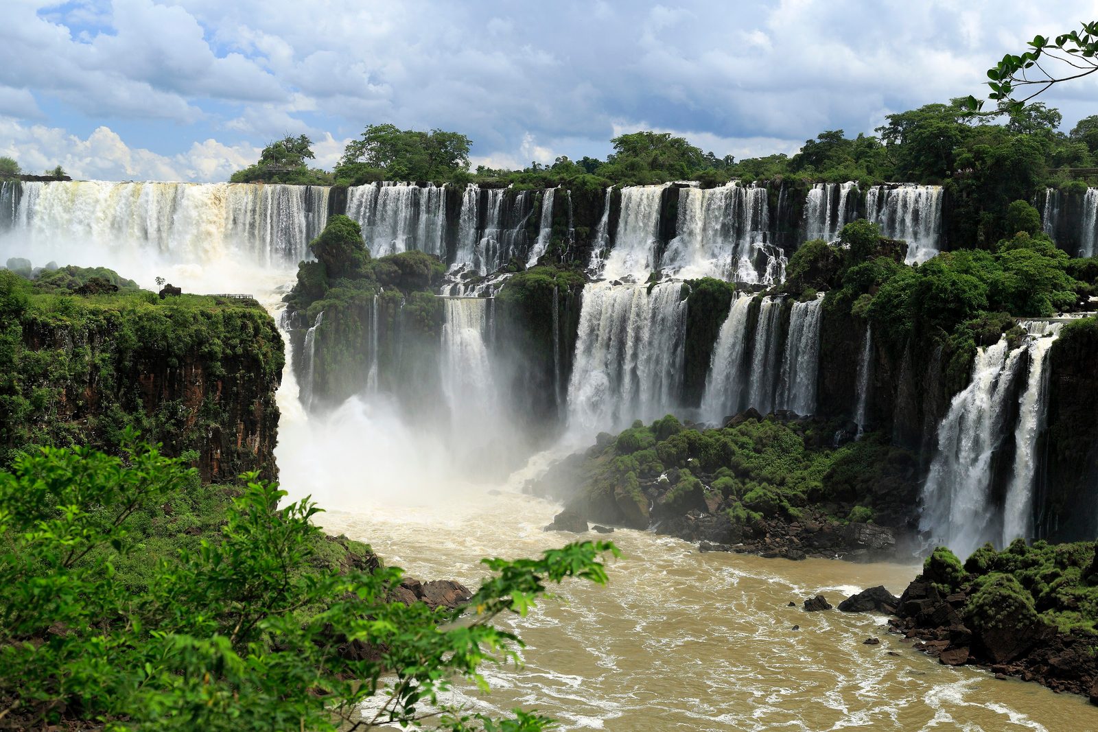
Rode a little train through steaming green forest, then walked out over a wide brown river on metal grating until the river stopped and dropped away into a horseshoe of white thunder. Small dark birds flew straight through the curtain and did not come out. A striped tail inspected my bag. Butterflies sat on my sleeves. I tried to count the falls, lost my place, and lost it again.
The short answer
Iguazú Falls is a system of waterfalls on the Iguazu River, where it drops off the edge of a basalt plateau on the border between the Argentine province of Misiones and the Brazilian state of Paraná. UNESCO describes a semicircular fall some 80 metres high and 2,700 metres across, standing on a line of basalt that spans the border. Islands along the edge break it into many separate falls; about half the river pours into one narrow chasm, the Garganta del Diablo, or Devil’s Throat, through which the border runs. By Wikipedia’s account nearly 80 per cent of the falls are on the Argentine side, although more than 95 per cent of the river’s basin is in Brazil. Two national parks protect them: Argentina’s Iguazú National Park, created in 1934 and inscribed by UNESCO in 1984, and Brazil’s Iguaçu National Park, created in 1939 and inscribed in 1986. The name comes from Guaraní words for water and big.
Why it's worth knowing
Ask how many waterfalls there are at Iguazú and you will be given a number. Argentina’s government says 275. Wikipedia’s accounts of the falls and of the Brazilian park give a range instead: from 150 to 300, depending on the river’s level. In high water, in Wikipedia’s description, the falls to the left of the Devil’s Throat merge into a single front; in low water, about 900 metres of the 2.7-kilometre edge carries no water at all. The number is not a property of the rock. It is a reading of the river on the day.
And the river varies enormously. The company that runs the Brazilian park gives the average flow as about 1.5 million litres a second, 1,500 cubic metres, and its record as 46.3 million litres a second in 2014, some thirty times that. In a severe drought in 2006, Wikipedia records, the flow fell to 300 cubic metres a second and stayed there until early December.
The parties do not even agree on which flood was biggest. Argentina’s government called the flood of October 2023 the largest in the river’s history, after it destroyed most of the walkway to the Devil’s Throat. The Brazilian park’s operator gives its peak, 24 million litres a second on 30 October 2023, as only the third largest on its record, behind 2014 and 35 million litres a second in 1983. Both are reported here as each party gives them.
The field notes
A walkway the river takes back
On the Argentine side, the most famous view is from a walkway that runs about a kilometre out across the upper river to a balcony over the Devil’s Throat. Argentina’s national parks administration reported that the October 2023 flood destroyed 90 per cent of it: 79 of the 99 sections and part of the balcony, along with the food area and toilets at the station and a stretch of the railway that brings visitors to it. The rebuilt circuit reopened on 13 July 2024.
Two years later the operator did not wait for the water. In July 2026, citing forecasts linked to El Niño that predicted high flows in September and October, the concessionaire Iguazú Argentina asked the national parks administration for permission to take the walkway apart as a precaution. The work began on Monday 3 August 2026: floors and railings were lifted, section by section, and stored at the Garganta del Diablo station until the river allows them back. The operator said it would take 40 days. The other circuits on the Argentine side stayed open.
Two countries, one edge
The two sides give different views of the same falls. Most of the falls are on the Argentine side, so the Argentine paths go over, beside and below them, with boats to San Martín Island. The Brazilian side faces most of them across the gorge: its main trail runs about a kilometre along the canyon to a walkway that reaches out towards the base of the Devil’s Throat.
The two countries also differ on the air above. Wikipedia’s account says helicopter flights over the falls have been offered from Brazil, while Argentina prohibits such tours because of their effect on wildlife.
The forest around it
The falls sit in subtropical Atlantic forest, which the spray keeps unusually lush. UNESCO lists more than 2,000 species of vascular plants in the Brazilian park and animals including tapirs, giant anteaters, howler monkeys, ocelots, jaguars and caimans. Among the animals listed in the Argentine park is the ring-tailed coati; the Argentine operator asks visitors not to touch or feed any wildlife, and to eat only in the areas set aside for it.
The first European to record the falls was the Spanish explorer Álvar Núñez Cabeza de Vaca, in 1541 by the date given in Wikipedia’s article on the falls, or 1542 in its article on the Argentine park.
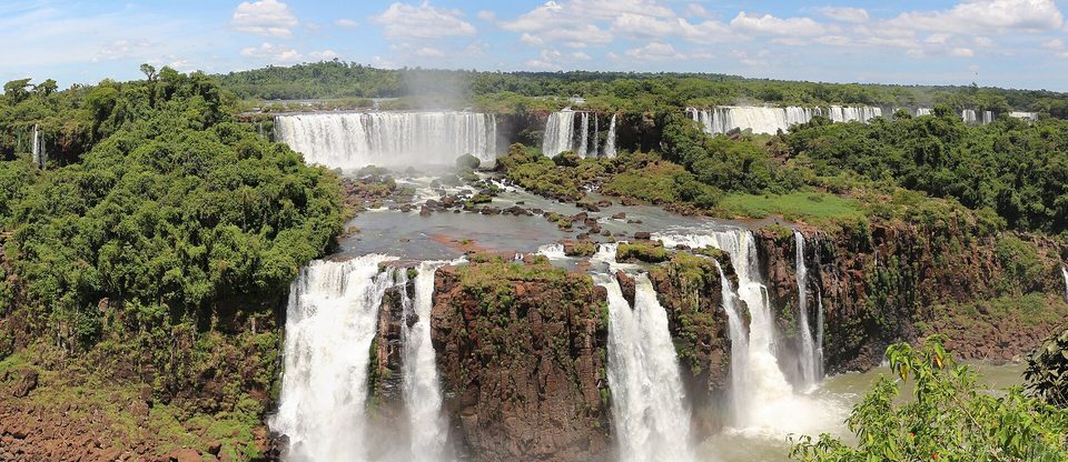
The Argentine falls seen across the gorge from Brazil’s Falls Trail, November 2018.
Photograph: Bernard Gagnon · CC BY-SA 4.0
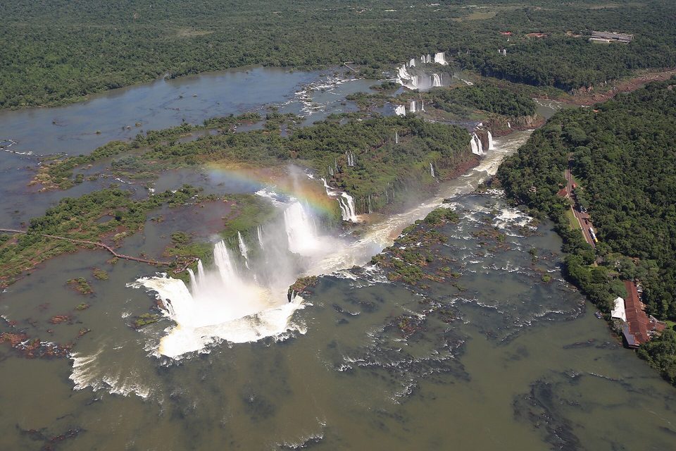
The Devil’s Throat from the air, November 2018, with the walkway to its balcony running out across the upper river at left.
Photograph: Bernard Gagnon · CC BY-SA 4.0
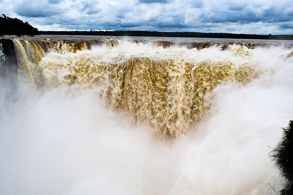
The Devil’s Throat from the balcony at the end of the Argentine walkway, February 2025.
Photograph: Brandon Antonio Segura Torres and Priscilla Vieto Bonilla · CC BY-SA 4.0

Young ring-tailed coatis in the forest of Iguaçu National Park, Brazil, November 2013.
Photograph: Deni Williams · Parque Nacional do Iguaçú - Iguaçu National Park - Filhotes de quati - South American Coati (ring-tailed coati - Nasua nasua) (14116252711) · CC BY 2.0 · cropped
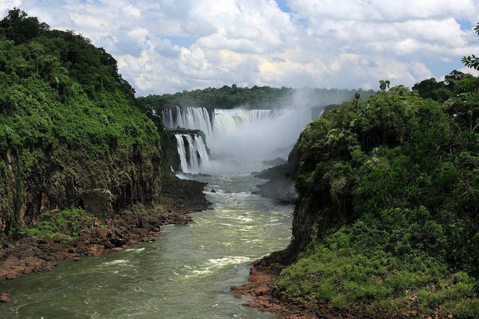
The gorge below the Devil’s Throat from the easternmost lookout of the Argentine Lower Circuit, January 2020.
Photograph: Falk2 · CC BY-SA 4.0
- See it from both banks if you can. They do not tell the same story.
- Wear something you do not mind being soaked in, and put the notebook away before the last corner.
- Keep your lunch zipped up and your hands to yourself. The striped visitors are wild, whatever they tell you.
- Ask at the gate which paths are open today, and do not sulk about the others. The river has its reasons.
- Count the falls. (Got one number from each bank. Both are on the list. The river has declined to choose.)
The walkway to the Devil’s Throat. On the Argentine side, a walkway runs about a kilometre out across the upper Iguazu River to a balcony over the edge of the Garganta del Diablo. It is built to be taken up. The flood of October 2023 destroyed 79 of its 99 sections; it was rebuilt and reopened in July 2024; and in August 2026, with high water forecast, its floors and railings were lifted one section at a time and stacked at the railway station to wait for the river to calm down.
Tally, in the marginDear walkway: thank you for holding me up over all that water, and for knowing when to step aside for it. I am sorry I only looked down once.
Getting there
How to get there. Each side has its own airport. On the Argentine side, Aerolíneas Argentinas flies from Buenos Aires to Puerto Iguazú’s international airport. On the Brazilian side, airlines including Azul, GOL and LATAM fly to Foz do Iguaçu. The two towns sit on opposite banks, and visiting both parks means crossing an international border with a passport.
Tickets. On the Argentine side, tickets can be bought online up to 30 days ahead through the operator, Iguazú Argentina, or the national parks administration; the ticket includes the trails and the Rainforest Ecological Train. On the Brazilian side, tickets are sold online for a chosen day and time, and include the park bus from the visitor centre to the Falls Trail.
Check what is open. At the time of writing, in September 2026, the Devil’s Throat circuit on the Argentine side is closed and its walkway has been dismantled as a flood precaution; the Upper and Lower Circuits are open. Ask the operator before you plan a day around the Devil’s Throat.
When to go. The climate is humid and subtropical, and Wikipedia gives December to February as usually the months of greatest flow. More water means more spray and fewer separate falls; less water means more of them. Wear clothes that can get soaked, and keep food packed away from the coatis.
Safety. The United States has Argentina at Level 1, exercise normal precautions, with increased caution only in the city of Rosario. It has Brazil at Level 2, exercise increased caution, because of crime and kidnapping, and advises against any travel within 160 kilometres of Brazil’s land borders with Paraguay and seven other neighbours. Its advisory says that restriction does not apply to the Foz do Iguaçu National Park. The exemption names the park, not the city of Foz do Iguaçu beside it, which lies on the border with Paraguay; the Argentine town of Puerto Iguazú is the base that sits under a Level 1 advisory.
Mark this place
Common questions
How many waterfalls are there at Iguazú Falls?
It depends on the river. Argentina’s government gives the number as 275. Wikipedia’s accounts of Iguazú Falls and of Brazil’s Iguaçu National Park give a range of 150 to 300 separate falls, depending on the water level: in high water many merge into one front, and in low water about 900 metres of the 2.7-kilometre edge runs dry.
Is Iguazú Falls in Argentina or Brazil?
Both. Iguazú Falls is on the Iguazu River where it forms the border between the Argentine province of Misiones and the Brazilian state of Paraná, and the border runs through the Devil’s Throat. By Wikipedia’s account nearly 80 per cent of the falls are on the Argentine side, and each country protects its side in a national park.
What is the Devil’s Throat at Iguazú?
The Devil’s Throat, Garganta del Diablo in Spanish and Garganta do Diabo in Portuguese, is the narrow U-shaped chasm at Iguazú Falls into which about half of the Iguazu River pours. Argentina’s government describes it as the fall with the greatest flow and height, about 80 metres. The border between Argentina and Brazil runs through it.
Is the Devil’s Throat walkway open?
Not at the time of writing, in September 2026. The Argentine operator, Iguazú Argentina, began dismantling the Devil’s Throat walkway on 3 August 2026 as a precaution against floods forecast for September and October, storing the sections at the Garganta del Diablo station. The same walkway was largely destroyed by a flood in October 2023 and reopened on 13 July 2024. Check with the operator before visiting.
How much water flows over Iguazú Falls?
The operator of Brazil’s Iguaçu National Park gives the average flow at Iguazú Falls as about 1.5 million litres a second, or 1,500 cubic metres. Its record is 46.3 million litres a second in 2014; Wikipedia gives the maximum as 45,700 cubic metres a second on 9 June 2014. In a drought in 2006 the flow fell to 300 cubic metres a second.
Which side of Iguazú Falls is better, Argentina or Brazil?
They offer different views of Iguazú Falls. Most of the falls are on the Argentine side, where trails run above, beside and below them and a walkway normally reaches the Devil’s Throat. The Brazilian side looks across the gorge at most of them, with a trail of about a kilometre ending at a walkway towards the base of the Devil’s Throat. Many visitors see both, which means crossing a border.
When were the Iguazú parks created?
Argentina’s Iguazú National Park was created in 1934 and Brazil’s Iguaçu National Park by a federal decree of 10 January 1939. UNESCO inscribed the Argentine park as a World Heritage Site in 1984 and the Brazilian park in 1986, together protecting a waterfall UNESCO describes as some 80 metres high and 2,700 metres across.
Is it safe to visit Iguazú Falls from Brazil?
The United States has Brazil at Level 2 and advises against travel within 160 kilometres of Brazil’s border with Paraguay, among others, but its advisory says this does not apply to the Foz do Iguaçu National Park. The city of Foz do Iguaçu, on the Paraguayan border, is not named in that exemption. Argentina, including Puerto Iguazú across the river, is at Level 1.