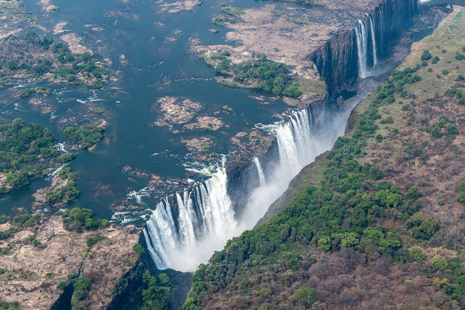

- Where
- The Zambezi River, on the border
between Zambia and Zimbabwe - Coordinates
- 17.9243° S
25.8572° E - Biome
- Basalt plateau, dry woodland,
and a rainforest fed by spray - The falls
- 1,708 m wide
up to 108 m high - Flow
- Peak in April
About a tenth of that by November - Status
- UNESCO World Heritage,
listed under both names - Best visited
- February–May for the flood,
September–January for the gorge
Saw it long before I heard it: a white column standing straight up out of the trees and drifting away across pale dry country. Close to, it rained on a clear day, and ferns grew thick where they had no business. Downstream, someone stepped off a steel bridge on a rope, on purpose. I was soaked through, like everybody, and have rarely been so pleased to be wet.
The short answer
Victoria Falls is the waterfall where the Zambezi River forms the border between Zambia and Zimbabwe. The whole river, 1,708 metres wide, drops in a single sheet into a chasm 80 metres deep at its western end and 108 metres deep in the centre; by the combined measure of width and height it is classed as the largest sheet of falling water in the world. The only outlet is a gap about 110 metres wide, two-thirds of the way along the far wall, and the river leaves through it into a zigzag series of gorges cut into a basalt plateau. Two names are on the World Heritage List: Victoria Falls, given by the Scottish missionary David Livingstone, the first European recorded as seeing it, on 16 November 1855; and Mosi-oa-Tunya, Lozi for “the smoke that thunders”.
Why it's worth knowing
A waterfall is usually the one part of a landscape that stays put while the river does the moving. At Victoria Falls it is the other way round. Look downstream from the bridge and the canyon that turns, and turns again, and turns again, is the falls’ own trail.
The plateau is basalt, laid down in the Jurassic and cracked afterwards by joints and faults. A river finds a line of weakness, falls into it, and wears it back; when a weaker line opens up upstream, the falls jump to it and the old gorge is left behind. In their 2010 chapter on the falls, A. Moore and F. Cotterill read the Batoka Gorge as six individual gorges and eight former positions of the falls; other accounts count the earlier fall lines differently, so the number is theirs. The east–west gorges follow joints or faults, some with about 50 metres of vertical displacement.
And the next jump may already have begun. Moore and Cotterill note that the falls may have started cutting back the next major gorge at the dip in the Devil’s Cataract, on the western, Zimbabwean side, where the lip is lowest and the most water arrives at flood. That is a judgement about a process that takes a very long time, and it is theirs, not a forecast.
It is also a different waterfall in different months. The Zambezi’s flood peaks in April; the minimum flow, in November, is around a tenth of that. At the top of the flood the foot and face of the falls cannot be seen through the spray; between September and January up to half the rock face may be dry.
The field notes
A canyon that works as a timeline
The gorges downstream are numbered in the order the river reaches them. The First Gorge is the one the falls drop into. The Second, 250 metres south of the falls and 2.15 kilometres long, is spanned by the Victoria Falls Bridge, and at its head the river makes a sharp right turn into the Boiling Pot, a pool about 150 metres across. The Third, 600 metres south, holds the Victoria Falls Power Station. The Songwe Gorge, 5.3 kilometres south, is the deepest at 140 metres, and the river in it rises and falls by up to 20 metres between the wet and dry seasons.
Behind all of it is an older piece of drainage history. According to the sources Wikipedia cites, the upper Zambezi once drained south through what is now Botswana to the Limpopo. A general uplift about 2 million years ago blocked that route and a great lake formed, the same palaeolake whose dry bed is now The Makgadikgadi Pans. About 20,000 years ago, in wetter conditions, it overflowed eastward and began cutting the Batoka Gorge through the basalt. The falls are what the river is doing at the head of that cut now.
The smoke that thunders
“Discovered” is the wrong word for 1855. Livingstone had been told about the falls before he reached them, and was paddled across to the island now named for him to see them. The Lozi name Mosi-oa-Tunya, “the smoke that thunders”, was already in use. The southern Tonga called the falls Shungu na mutitima, given as “boiling water”, and the Matabele, later arrivals, aManz’ aThunqayo; the account Wikipedia draws from the Northern Rhodesia Journal reads all of these names as variations on the smoke and the thunder.
European maps had the falls earlier still. A map drawn by Nicolas de Fer in 1715 marks them in the correct position, along with trade routes that Livingstone followed 140 years later; Emil Holub made the first detailed plan of the falls and their surroundings in 1875, published in 1880. Europeans were, in the account Wikipedia gives, sceptical of the reports they were given, perhaps because a plateau with no mountains nearby made a great fall seem unlikely.
Two seasons, two waterfalls
The Zambezi has a rainy season from late November to early April and a dry season for the rest of the year; the annual flood is February to May, with the peak in April. The spray typically rises over 400 metres, sometimes twice that, and can be seen from up to 50 kilometres away. At full moon a moonbow can appear in it.
When the water drops, the islets on the crest widen and multiply. From September to January it becomes possible to see the bottom of the First Gorge along most of its length, and to walk down to the gorge floor on the Zimbabwean side. One consequence is the Devil’s Pool, a natural pool at the lip of the falls on the Zambian side, at the western tip of Livingstone Island. When the flow is right, usually between September and December, a rock barrier makes an eddy with minimal current, and swimmers can float at the edge of the drop.
In 2019, unusually low rain reduced the falls to their lowest flow in a century. National Geographic’s reporting in February 2020 highlighted the threat from a hotter, drier region and more frequent drought years, and the Wikipedia summary of it records fears that the falls could join the World Heritage sites classed as last-chance destinations.
Two countries, one bridge
The falls were well known to the people who lived beside them long before any railway. Visitors began to arrive in numbers in 1905, when the railway reached the river: Cecil Rhodes wanted his Cape-to-Cairo line to cross the Zambezi where the spray would fall on passing trains, so the bridge was built at the Second Gorge. The Victoria Falls Hotel opened in 1904 to house the first visitors.
The two banks have had different fortunes since. Northern Rhodesia became Zambia in 1964, Rhodesia declared independence unilaterally in 1965, and in 1966 Zambia restricted or stopped border crossings, which were not fully reopened until 1980. Each side now has its own national park: Mosi-oa-Tunya National Park in Zambia, 66 square kilometres, and Victoria Falls National Park in Zimbabwe, 23 square kilometres. The spray feeds a rainforest with pod mahogany, ebony, ivory palm and wild date palm, in country where mopane woodland is the norm. Below the falls the river holds 39 species of fish; above them, 84. The falls are that effective a barrier.
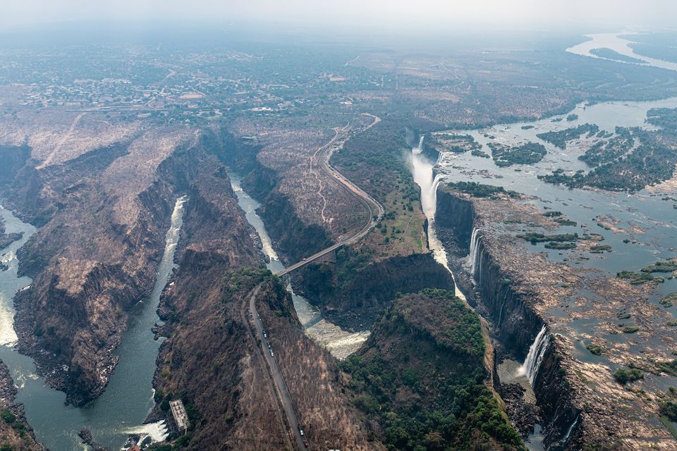
The gorges below the falls from the air, with the Victoria Falls Bridge across the second.
Photograph: Christoph Strässler · Victoria Falls, Zimbabwe - 51642221289 · CC BY-SA 2.0 · cropped
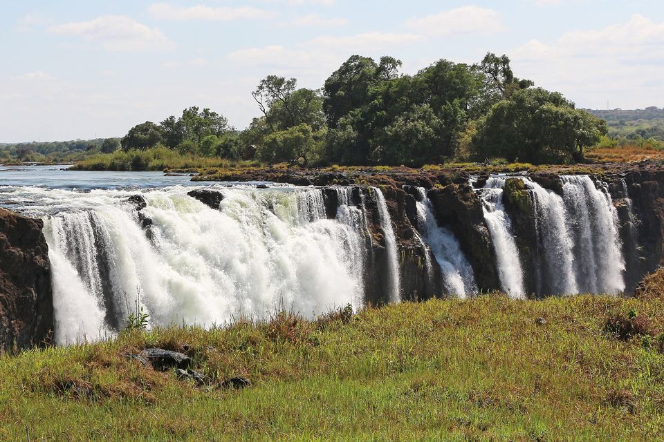
The falls in November 2017, near the low point of the year, split into separate streams.
Photograph: Bernard Gagnon · CC BY-SA 4.0 · cropped
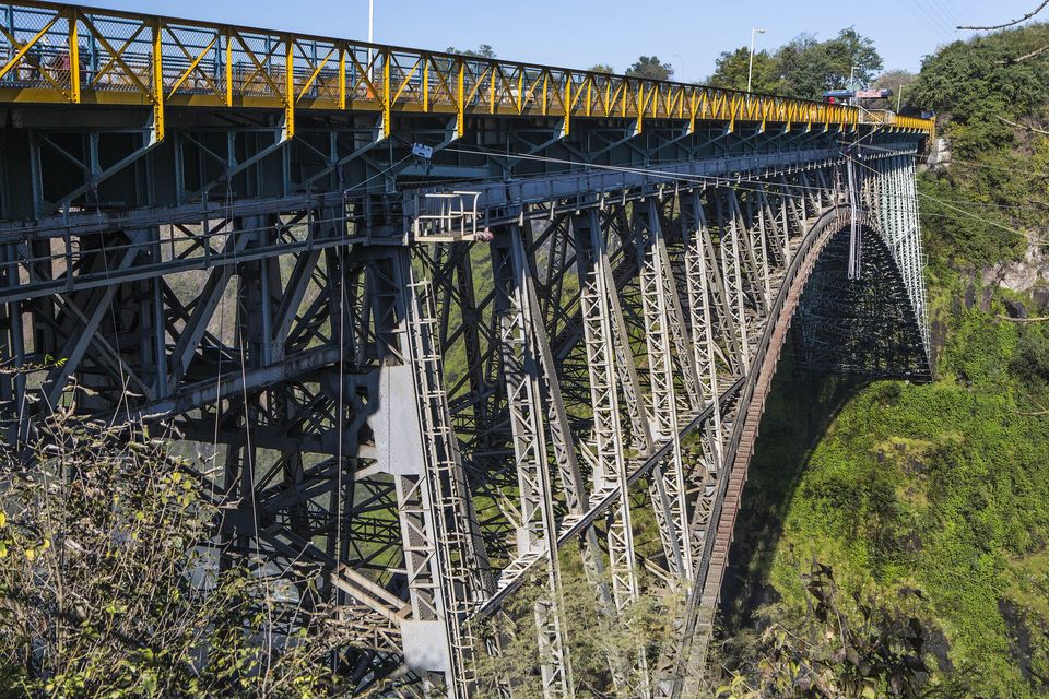
The Victoria Falls Bridge across the Second Gorge, completed in 1905.
Photograph: Ninara from Helsinki, Finland · Victoria Falls Bridge (14349891367) · CC BY 2.0
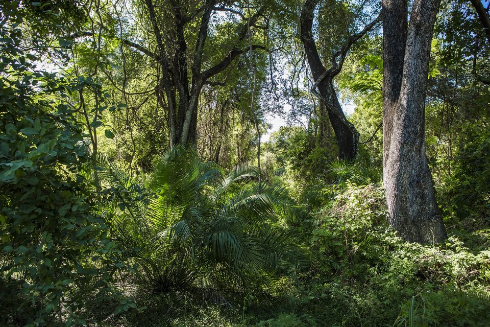
The rainforest that the spray feeds, on the Zimbabwean side.
Photograph: Ninara from Helsinki, Finland · Rain forest, Victoria Falls, Zimbabwe (14350023147) · CC BY 2.0
- Go twice if you can, once with the water high and once with it low.
- Bring a rain jacket in the dry season too. The spray does not check the calendar.
- Look down the gorge, not only at the falls, and read the zigzag.
- Stay for the moon, if the moon is full. (One more thing for the list. There is always one more thing.)
- Learn the older names for it and use them. It was somebody’s long before it was on a map.
A bridge placed to be rained on. Cecil Rhodes, who never saw the falls and died before work on the bridge began, is recorded as instructing the engineers to build it “where the trains, as they pass, will catch the spray of the Falls”, so it stands across the Second Gorge, just below them. It was completed in 1905, and it is still a way across: a border post at each end, one country on either side, a steel arch between them and the river far below. Whether the spray reaches you on the deck depends on the month and the wind, and this entry does not promise it.
Tally, in the marginI crossed it admiring the view and was halfway over before I noticed I was being rained on. I gather that was the whole idea.
Getting there
How to get there. Both banks have a town and an airport: Livingstone in Zambia and Victoria Falls in Zimbabwe. Most travellers connect through a regional hub in southern or eastern Africa. Road and rail also reach both sides, and Chobe National Park in Botswana is a day trip from the falls. The two banks are joined by the Victoria Falls Bridge, which is also a border crossing, so carry your passport and check each country’s current visa rules for your nationality before you book.
Which side. The falls are divided into named streams that run from the Zimbabwean side in the west — Devil’s Cataract, the Main Falls, the Rainbow Falls — to the Eastern Cataract on the Zambian side. The Boiling Pot is reached by a steep footpath from the Zambia side, and in the low-water months it is possible to walk to the bottom of the First Gorge on the Zimbabwe side. Plan for both banks if you have the time and the visas.
When to go. This is the decision that matters. From February to May, the flood, you get the most water and the least view: the foot and face of the falls vanish into spray, and you will be wet. From September to January the rock face is more visible and the gorge is easier to see, the Devil’s Pool is possible in the right months, and the falls are thinner. Neither is wrong; they are different waterfalls.
What to book ahead. Trips to Livingstone Island and the Devil’s Pool, scenic flights over the falls, whitewater rafting in the gorges and bungee jumping from the bridge are all run by operators, and seasonal ones fill up. Ask about the river level before you commit to the swim. Park entry fees are set separately by each country and change; check the current tariffs.
Practical notes. Bring a rain jacket in every season and something waterproof for the camera. Paths near the edge are wet and slippery. The United States advises normal precautions in Zambia and increased caution in Zimbabwe, for crime; travel insurance with medical cover is a sensible condition of going.
Mark this place
Common questions
How wide and how high is Victoria Falls?
Victoria Falls on the Zambezi River is 1,708 metres wide and drops 80 metres at its western end to 108 metres in the centre, into the chasm called the First Gorge. Wikipedia’s account notes that, by the combined measure of width and height, this makes it the largest sheet of falling water in the world; the claim rests on the two measures together, not on either alone.
What does Mosi-oa-Tunya mean?
Mosi-oa-Tunya is the Lozi name for Victoria Falls and means “the smoke that thunders”, for the spray that rises over 400 metres and the noise. The Tonga name, Shungu na mutitima, means “boiling water”. Both Victoria Falls and Mosi-oa-Tunya appear on the World Heritage List, and the national park on the Zambian side is named Mosi-oa-Tunya.
Who discovered Victoria Falls?
The Scottish missionary David Livingstone is the first European recorded as seeing Victoria Falls, on 16 November 1855, and he named them for Queen Victoria. Local peoples had known them for much longer under names such as Mosi-oa-Tunya, and a 1715 map by Nicolas de Fer already marks the falls in the correct position, 140 years before his visit.
Why does Victoria Falls have a zigzag gorge below it?
Because the falls have moved upstream several times. The Zambezi flows over a basalt plateau cut by joints and faults; when a weaker line opens upstream, the falls shift to it and abandon the old gorge. A. Moore and F. Cotterill read the Batoka Gorge as six gorges and eight former positions of the falls, and think the next cut may have started at the Devil’s Cataract.
When is the best time to see Victoria Falls?
It depends on the view. The Zambezi’s flood runs February to May and peaks in April, when the spray can hide the foot and face of the falls entirely. From September to January up to half the rock face can be dry and the bottom of the First Gorge is visible, with the minimum flow in November at about a tenth of April’s.
Does Victoria Falls ever dry up?
Not completely. The minimum flow, in November, is around a tenth of the April flood, and up to half the rock face may be dry between September and January. In 2019 unusually low rain reduced Victoria Falls to its lowest flow in a century, and National Geographic highlighted in 2020 that drought years in the region are becoming more frequent.
Is Victoria Falls in Zambia or Zimbabwe?
Both. Victoria Falls lies on the Zambezi, which forms the border between the two countries, and each has a national park at the falls: Mosi-oa-Tunya National Park (66 square kilometres) in Zambia and Victoria Falls National Park (23 square kilometres) in Zimbabwe. The Victoria Falls Bridge, completed in 1905, joins the two banks at the Second Gorge and is a border crossing.
What is the Devil’s Pool?
The Devil’s Pool is a natural pool on the Zambian side of Victoria Falls, at the western tip of Livingstone Island, right at the lip of the drop. When the flow is right, usually between September and December, a rock barrier creates an eddy with minimal current, and swimmers can float at the edge. It is only possible when the flow is right.