
- Where
- Bay of Mont-Saint-Michel
Manche, Normandy - Coordinates
- 48.636° N
1.511° W - Tidal range
- Up to about 15 m
(Mont Saint-Michel tourist office) - Causeway
- Raised road of 1879
replaced by a bridge on piles, 2014 - Couesnon dam
- In service 2009
(Établissement public) - Residents
- 23 (2023)
(per Wikipedia) - Advisory
- France Level 2
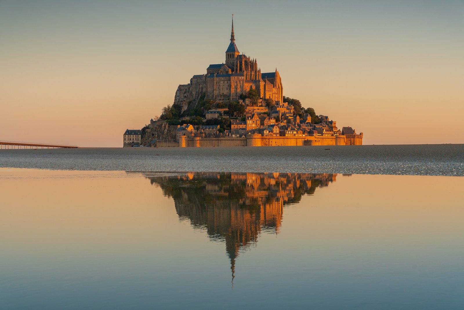
A long pale bridge on legs took me across, sheep on the salt grass behind me and grey sand ahead to the horizon. The village climbed the rock in steps to a church at the very top. At evening the sea came back across the sand, and the last of the path simply went under. I waited on the walls with everyone else. Nobody minded being an island.
The short answer
Mont-Saint-Michel is a granite rock about 960 metres round and 92 metres high, standing in the bay at the mouth of the Couesnon about a kilometre off the coast of Normandy. A walled village climbs its slope to the abbey at the top. By Wikipedia’s account the island had 23 residents in 2023 and receives more than three million visitors a year. UNESCO inscribed Mont-Saint-Michel and its bay as a World Heritage Site in 1979. The tides in the bay are enormous: the local tourist office puts the range at up to 15 metres, and calls it the largest in continental Europe; Wikipedia gives roughly 14.
Why it's worth knowing
For most of its history the rock was cut off at high tide and joined to the land at low tide, and people reached it across the sand. Medieval pilgrims crossing the flats called it St Michael in peril of the sea. In 1879 a raised causeway was built out to it, dry at every tide, and by Wikipedia’s account it stopped the tide scouring the silt from around the rock. Polders reclaimed for pasture and a canalised river added to the silting, and the salt meadow crept toward the walls.
France decided to put the island back. The Établissement public national du Mont-Saint-Michel, the public body that now runs the site, describes a project to restore its maritime character that unfolded over three decades. Its centrepiece is a new dam on the Couesnon, put into service in 2009 in place of a tide-gate dam of 1969, which uses the force of the tides and the river to limit silting around the rock. The causeway and the car park at its foot were removed; a car park on the mainland opened in 2012, 2.5 km away; and a bridge by the Austrian architect Dietmar Feichtinger, raised on piles so that water can flow under it, opened to the public in July 2014. Wikipedia gives the cost announced for the project in 2006 as €200 million, and reports that at the abbey’s millennium in 2023 the French president said the silting had been lessened and the rock made an island again.
An island, here, is a matter of degree. The tourist office says the sea reaches the rock only at spring tides, roughly every two weeks, and that at the biggest of them the Mont is cut off for about an hour, with water over the esplanade between the bridge and the village gate.
The field notes
The dam that lets the sea back in
The Couesnon dam stands on the mainland where the river enters the bay. Shortly after high tide its gates close, and the river channel holds the sea water back like a reservoir as the tide goes out; about six hours after high tide, the tourist office explains, the gates open progressively and the released water chases the accumulated sediment away from the rock. The Établissement public publishes each day’s water releases on its website beside the tide tables, and it monitors the dam’s fish passes for the young eels that climb through them.
A rock with a long record
Before the monks came the rock was called Mont Tombe. The founding story recorded by Wikipedia is a legend: the archangel Michael appeared in 708 to Aubert, bishop of Avranches, and told him to build a church on the islet. A statue of the archangel now stands on the abbey church’s spire. The Mont held out against English sieges in the Hundred Years’ War, and two bombards the English abandoned in 1434 are still on display. After the Revolution the abbey became a prison, which closed in 1863; restoration followed, and it was classified as a historic monument in 1874.
Who lives there now
Since 2001 a small community of the Monastic Fraternities of Jerusalem, monks and nuns, has lived on the Mont at the invitation of the bishop of Coutances and Avranches. By Wikipedia’s account they meet to sing the office in the abbey four times a day, and are tenants of the abbey rather than its managers. On the salt meadows around the bay graze the sheep raised for agneau de pré-salé, salt-meadow lamb.
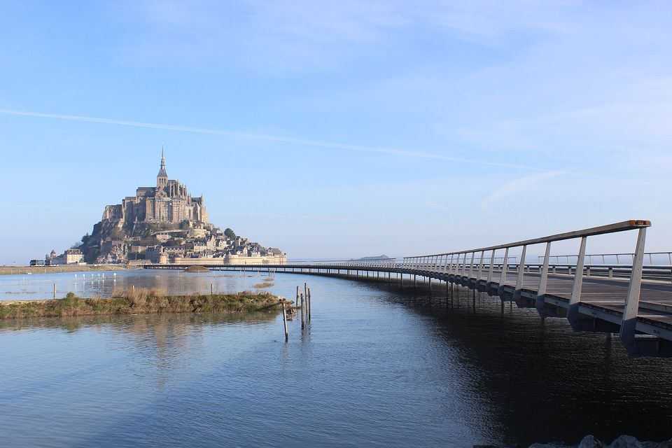
The mount at a spring high tide in April 2014, with the new walkway running out over the water.
Photograph: Mathias Neveling · CC BY-SA 4.0
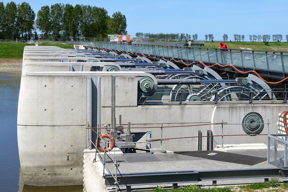
The Couesnon dam: its gates hold back the river at high tide, then release it to flush silt away from the mount.
Photograph: Pline · Barrage sur le Couesnon au Mont St Michel DSC 0312 · CC BY-SA 3.0 · cropped
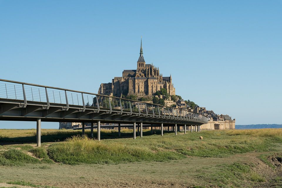
Dietmar Feichtinger's bridge on piles, opened in 2014, crossing the salt meadow to the mount.
Photograph: Lynx1211 · CC BY-SA 4.0
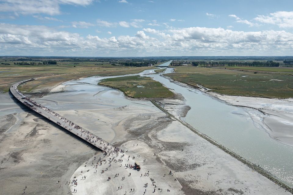
From the abbey's terraces: the bridge, the bay sands and the canalised Couesnon, August 2018.
Photograph: Giorgio Galeotti · CC BY 4.0
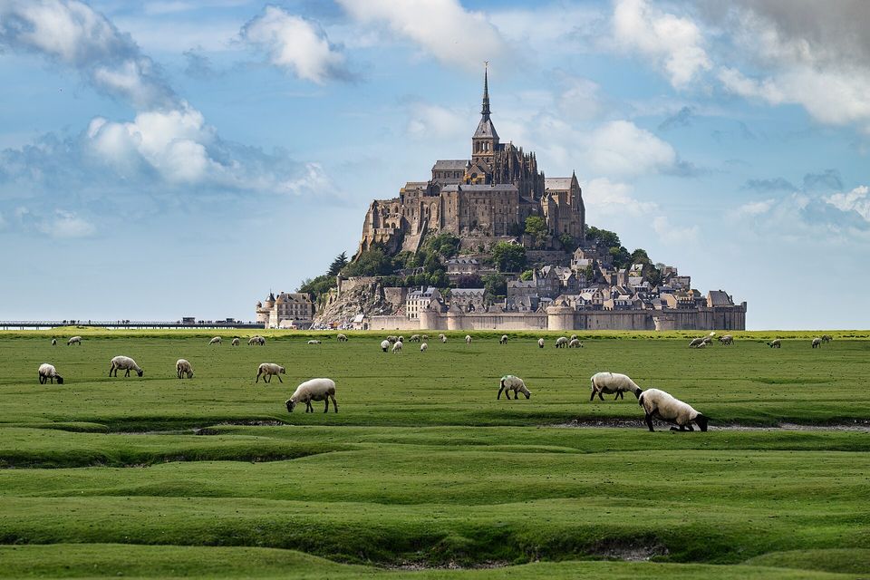
Salt-meadow sheep grazing the grass that the tides flood, May 2026.
Photograph: Eric Kilby · CC BY-SA 4.0
- Stay the night on the rock, so you are still there when the day empties out and the sea comes in.
- Cross the sand only behind a guide, barefoot, and put your feet exactly where the guide put theirs.
- Write your list well above the tideline. The first draft went on the sand, and the sea is keeping it.
- If the community is singing in the abbey church, stand at the back until the last note has gone.
- Read the tide table at breakfast and plan the day around the sea. It will not return the favour.
The Couesnon dam. A low dam across the river where it meets the bay, put into service in 2009 in place of an older tide-gate dam. Shortly after high tide its gates close, and the river holds a reservoir of sea water as the tide falls away; about six hours later they open, a little at a time, and the released water scours the silt away from the rock. The people who run it publish the times of each day’s releases, like a timetable. Most dams are built to keep the sea out. This one borrows the sea and gives it back where the island needs it.
Tally, in the marginFiled first under walls. Moved, after watching it work, to friends of the sea.
Getting there
How to get there. Drivers leave their cars in the mainland car park, 2.5 km from the rock, and cross by the free shuttle, le Passeur, which runs every five to fifteen minutes depending on the season; on foot, which the site’s own guidance puts at forty minutes or more; or in the paid horse-drawn Maringote. The nearest town with a railway station is Pontorson, and the nearest airport is Rennes, 88 km south, by Wikipedia’s account.
When to go. By Wikipedia’s account the day-trip crowds make the village busiest from 10:00 to 16:00, especially in summer, and the site has offered free parking after 18:30 outside July and August to encourage evening visits. The abbey is open all year except a few holidays, and guided tours are included in its ticket; the tourist office recommends booking ahead. To see the rock become an island, come on a spring-tide day: the Établissement public publishes the year’s big tides, and the tourist office advises allowing an hour to an hour and a half after high tide before the path to the bridge is clear again.
Walking on the bay. The sands have quicksand and shifting rivers, and the tide comes in fast. The tourist office describes guided crossings, from an hour and a half on the quicksand to a 13-kilometre round trip, led by guides certified by the prefecture of the Manche, and says plainly that it is very dangerous to go out into the bay alone. Crossings are made barefoot or in neoprene socks, in shorts.
Safety. The State Department has France at Level 2, exercise increased caution, for terrorism and civil unrest. The advisory names no region, and it warns of pickpocketing in crowded tourist places.
Mark this place
Common questions
Is Mont-Saint-Michel an island?
Mont-Saint-Michel is a tidal island: at low tide it is surrounded by sand, and on the largest spring tides the sea comes all the way round it. Since the raised causeway of 1879 was replaced by a bridge on piles in 2014, the Mont Saint-Michel tourist office says the rock is cut off for about an hour at the biggest tides, with water over the esplanade below the village.
Why was a dam built at Mont-Saint-Michel?
The dam on the Couesnon, in service since 2009, was built to stop Mont-Saint-Michel silting up. It closes shortly after high tide to hold sea water in the river channel, then opens progressively about six hours after high tide so the released water pushes sediment away from the rock. The Établissement public national du Mont-Saint-Michel says it limits silting around the island.
How do you get to Mont-Saint-Michel?
Visitors park in the mainland car park 2.5 km from Mont-Saint-Michel and cross the bridge by the free Passeur shuttle, on foot in about forty minutes or more, or in the paid horse-drawn Maringote. The nearest town with a railway station is Pontorson, and the nearest airport is Rennes, about 88 km to the south.
Can you walk across the bay to Mont-Saint-Michel?
Only with a guide. The Mont Saint-Michel tourist office describes guided crossings of the bay led by guides certified by the prefecture of the Manche, from a short quicksand walk to a 13-kilometre round trip, made barefoot, and warns that going out into the bay alone is very dangerous because of the tides, the quicksand and the shifting rivers.
How big are the tides at Mont-Saint-Michel?
The Mont Saint-Michel tourist office puts the tidal range in the bay at up to 15 metres, which it calls the largest in continental Europe; Wikipedia gives roughly 14 metres. The sea reaches the rock only at spring tides, about every two weeks.
Does anyone live on Mont-Saint-Michel?
Yes. Wikipedia gives the island’s population as 23 in 2023. Since 2001 a community of the Monastic Fraternities of Jerusalem, monks and nuns, has lived on Mont-Saint-Michel and sings the office in the abbey several times a day; they are tenants of the abbey, not its managers.
When was the bridge to Mont-Saint-Michel built?
The bridge to Mont-Saint-Michel, designed by the Austrian architect Dietmar Feichtinger, opened to the public in July 2014. It replaced the raised causeway of 1879, which had let silt build up around the island, and stands on piles so that water can flow beneath it.
What time of day is Mont-Saint-Michel least crowded?
Mont-Saint-Michel is busiest from about 10:00 to 16:00, when day-trippers fill the village, especially in summer. Wikipedia reports that the site has offered free parking after 18:30 outside July and August to spread visits into the evening; by the same account there are 132 hotel rooms inside the walls for those who stay the night.